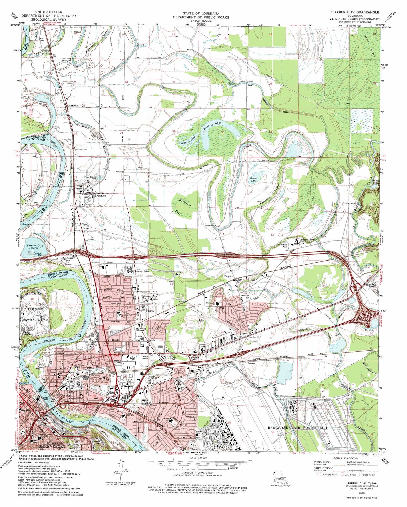
Bossier City Topo Map Louisiana
To zoom in, hover over the map of Bossier City
USGS Topo Quad 32093e6 - 1:24,000 scale
| Topo Map Name: | Bossier City |
| USGS Topo Quad ID: | 32093e6 |
| Print Size: | ca. 21 1/4" wide x 27" high |
| Southeast Coordinates: | 32.5° N latitude / 93.625° W longitude |
| Map Center Coordinates: | 32.5625° N latitude / 93.6875° W longitude |
| U.S. State: | LA |
| Filename: | o32093e6.jpg |
| Download Map JPG Image: | Bossier City topo map 1:24,000 scale |
| Map Type: | Topographic |
| Topo Series: | 7.5´ |
| Map Scale: | 1:24,000 |
| Source of Map Images: | United States Geological Survey (USGS) |
| Alternate Map Versions: |
Bossier City LA 1955, updated 1956 Download PDF Buy paper map Bossier City LA 1960, updated 1960 Download PDF Buy paper map Bossier City LA 1960, updated 1969 Download PDF Buy paper map Bossier City LA 1975, updated 1976 Download PDF Buy paper map Bossier City LA 1975, updated 1978 Download PDF Buy paper map Bossier City LA 1975, updated 1978 Download PDF Buy paper map Bossier City LA 1998, updated 2003 Download PDF Buy paper map Bossier City LA 2012 Download PDF Buy paper map Bossier City LA 2015 Download PDF Buy paper map |
1:24,000 Topo Quads surrounding Bossier City
Vivian South |
Gilliam |
Hughes |
Ivan |
Cotton Valley |
Mooringsport |
Dixie |
Benton |
Bodcau Lake |
Hortman |
Blanchard |
North Highlands |
Bossier City |
Eastwood |
Doyline |
Greenwood |
Shreveport West |
Shreveport East |
Sligo |
Koran |
Spring Ridge |
Stonewall |
Wallace Lake |
Elm Grove |
Bossier Point |
> Back to 32093e1 at 1:100,000 scale
> Back to 32092a1 at 1:250,000 scale
> Back to U.S. Topo Maps home
Bossier City topo map: Gazetteer
Bossier City: Airports
Bossier Medical Center Heliport elevation 51m 167′Louisiana State Police Troop G Headquarters Facilities Heliport elevation 50m 164′
Merritt Airport elevation 53m 173′
Pioneer Field Flight Park elevation 52m 170′
Shreveport Downtown Airport elevation 53m 173′
Bossier City: Bridges
Long-Allen Bridge elevation 45m 147′Bossier City: Canals
Flat River Drainage Canal elevation 49m 160′Bossier City: Crossings
Interchange 11 elevation 51m 167′Interchange 12 elevation 51m 167′
Interchange 13 elevation 51m 167′
Interchange 18 elevation 56m 183′
Interchange 19A elevation 57m 187′
Interchange 19B elevation 52m 170′
Interchange 20 elevation 53m 173′
Interchange 21 elevation 51m 167′
Interchange 22 elevation 51m 167′
Interchange 23 elevation 51m 167′
Interchange 26 elevation 51m 167′
Bossier City: Guts
Alligator Bayou elevation 47m 154′Benoit Bayou elevation 53m 173′
Racetrack Bayou elevation 49m 160′
Bossier City: Lakes
Green Lake elevation 50m 164′Round Lake elevation 49m 160′
Swan Lake elevation 50m 164′
Bossier City: Oilfields
Honore Gas Field elevation 52m 170′Bossier City: Parks
Highland Historic District elevation 72m 236′Hooter Park elevation 51m 167′
Princess Park elevation 65m 213′
Shed Road Park elevation 51m 167′
Shreveport Commerical Historic District elevation 60m 196′
Swan Lake Park elevation 51m 167′
Tuttle Park elevation 51m 167′
Veterans Park elevation 51m 167′
Walbrook Park elevation 51m 167′
Bossier City: Populated Places
Airline Park Estates elevation 51m 167′Bossier City elevation 53m 173′
Brookhaven Estates elevation 51m 167′
Brownlee elevation 52m 170′
Brownlee Estates elevation 52m 170′
Carriage Oaks elevation 51m 167′
Cloverdale elevation 51m 167′
Coleman Park elevation 49m 160′
Ferguson elevation 52m 170′
Fosters elevation 51m 167′
Glendale elevation 51m 167′
Green Acres elevation 51m 167′
Greenacres Place elevation 51m 167′
Hinkle elevation 52m 170′
Honore elevation 53m 173′
Meadowview Park elevation 50m 164′
Parkland Village elevation 50m 164′
Southern Terrace elevation 51m 167′
Swan Lake elevation 51m 167′
Vanceville elevation 53m 173′
Waller elevation 50m 164′
Whitehurst elevation 51m 167′
Bossier City: Post Offices
Bossier City Post Office elevation 53m 173′Bossier City: Reservoirs
Bossier City Reservoir elevation 55m 180′Bossier City: Streams
Cross Bayou elevation 45m 147′Cross Bayou elevation 45m 147′
Macks Bayou elevation 48m 157′
Willow Chute elevation 49m 160′
Bossier City: Swamps
Horseshoe Lake elevation 51m 167′Bossier City digital topo map on disk
Buy this Bossier City topo map showing relief, roads, GPS coordinates and other geographical features, as a high-resolution digital map file on DVD: