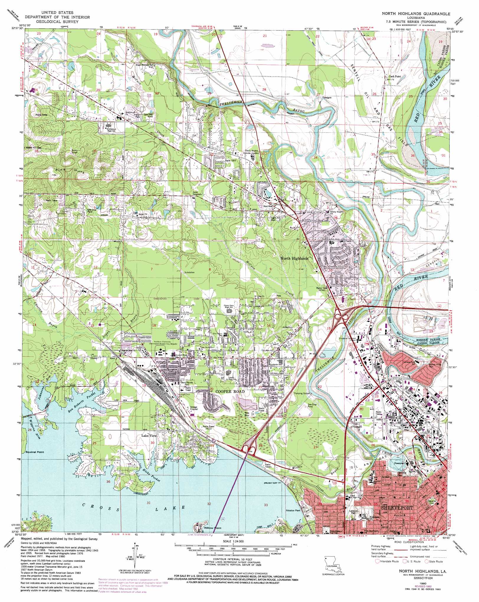
North Highlands Topo Map Louisiana
To zoom in, hover over the map of North Highlands
USGS Topo Quad 32093e7 - 1:24,000 scale
| Topo Map Name: | North Highlands |
| USGS Topo Quad ID: | 32093e7 |
| Print Size: | ca. 21 1/4" wide x 27" high |
| Southeast Coordinates: | 32.5° N latitude / 93.75° W longitude |
| Map Center Coordinates: | 32.5625° N latitude / 93.8125° W longitude |
| U.S. State: | LA |
| Filename: | o32093e7.jpg |
| Download Map JPG Image: | North Highlands topo map 1:24,000 scale |
| Map Type: | Topographic |
| Topo Series: | 7.5´ |
| Map Scale: | 1:24,000 |
| Source of Map Images: | United States Geological Survey (USGS) |
| Alternate Map Versions: |
North Shreveport LA 1955, updated 1956 Download PDF Buy paper map North Highlands LA 1960, updated 1960 Download PDF Buy paper map North Highlands LA 1960, updated 1969 Download PDF Buy paper map North Highlands LA 1975, updated 1976 Download PDF Buy paper map North Highlands LA 1980, updated 1981 Download PDF Buy paper map North Highlands LA 1980, updated 1986 Download PDF Buy paper map North Highlands LA 1980, updated 1992 Download PDF Buy paper map North Highlands LA 2012 Download PDF Buy paper map North Highlands LA 2015 Download PDF Buy paper map |
1:24,000 Topo Quads surrounding North Highlands
Trees |
Vivian South |
Gilliam |
Hughes |
Ivan |
Potters Point |
Mooringsport |
Dixie |
Benton |
Bodcau Lake |
Latex |
Blanchard |
North Highlands |
Bossier City |
Eastwood |
Waskom |
Greenwood |
Shreveport West |
Shreveport East |
Sligo |
Panola |
Spring Ridge |
Stonewall |
Wallace Lake |
Elm Grove |
> Back to 32093e1 at 1:100,000 scale
> Back to 32092a1 at 1:250,000 scale
> Back to U.S. Topo Maps home
North Highlands topo map: Gazetteer
North Highlands: Bays
Ben Roberts Pocket elevation 52m 170′Hicks Pocket elevation 52m 170′
Johnsons Arm elevation 52m 170′
Wiggens Arm elevation 52m 170′
North Highlands: Canals
Soda Lake Canal (historical) elevation 52m 170′North Highlands: Capes
Willow Point elevation 59m 193′North Highlands: Channels
Gilmer Ditch elevation 45m 147′The Pass elevation 45m 147′
North Highlands: Cliffs
Albany Bluffs elevation 58m 190′North Highlands: Crossings
Cash Point Ferry (historical) elevation 48m 157′Interchange 5 elevation 59m 193′
Interchange 7 elevation 54m 177′
North Highlands: Dams
Cross Lake Dam and Spillway elevation 45m 147′North Highlands: Oilfields
Sentell Oil and Gas Field elevation 52m 170′Shreveport Oil Field elevation 49m 160′
North Highlands: Parks
Allendale Park elevation 72m 236′David Raines Park elevation 53m 173′
Lakeside Park elevation 60m 196′
Lakeside Recreation Center elevation 69m 226′
Lakeview Park elevation 53m 173′
Lear-Hawkins Park elevation 58m 190′
Lincoln Park elevation 59m 193′
Mamie Hicks Park elevation 51m 167′
Mount Moriah Park elevation 62m 203′
SWEPCO Park elevation 52m 170′
Travis Street Park elevation 58m 190′
North Highlands: Populated Places
Albany (historical) elevation 66m 216′Audrey Park elevation 64m 209′
Cash Point elevation 53m 173′
Conn elevation 54m 177′
Cooper Road elevation 56m 183′
Dorian Terrace elevation 58m 190′
Gas Center elevation 58m 190′
Good Roads elevation 53m 173′
Hanna Park elevation 63m 206′
Highland Square elevation 58m 190′
Indian Hills Estates elevation 77m 252′
Lakeside Acres elevation 61m 200′
Lakeview elevation 56m 183′
North Highlands elevation 61m 200′
North Shreveport elevation 60m 196′
Northwoods elevation 64m 209′
One North Place elevation 62m 203′
Pine Hill Estates elevation 61m 200′
Shreveport elevation 46m 150′
North Highlands: Post Offices
Shreveport Post Office elevation 66m 216′North Highlands: Reservoirs
Cross Lake elevation 45m 147′North Highlands: Streams
Choctaw Bayou elevation 53m 173′Logan Bayou elevation 52m 170′
Mahlin Bayou elevation 55m 180′
McCain Creek elevation 45m 147′
Middle Bayou elevation 45m 147′
Twelvemile Bayou elevation 45m 147′
North Highlands: Summits
Pine Hills elevation 107m 351′North Highlands digital topo map on disk
Buy this North Highlands topo map showing relief, roads, GPS coordinates and other geographical features, as a high-resolution digital map file on DVD: