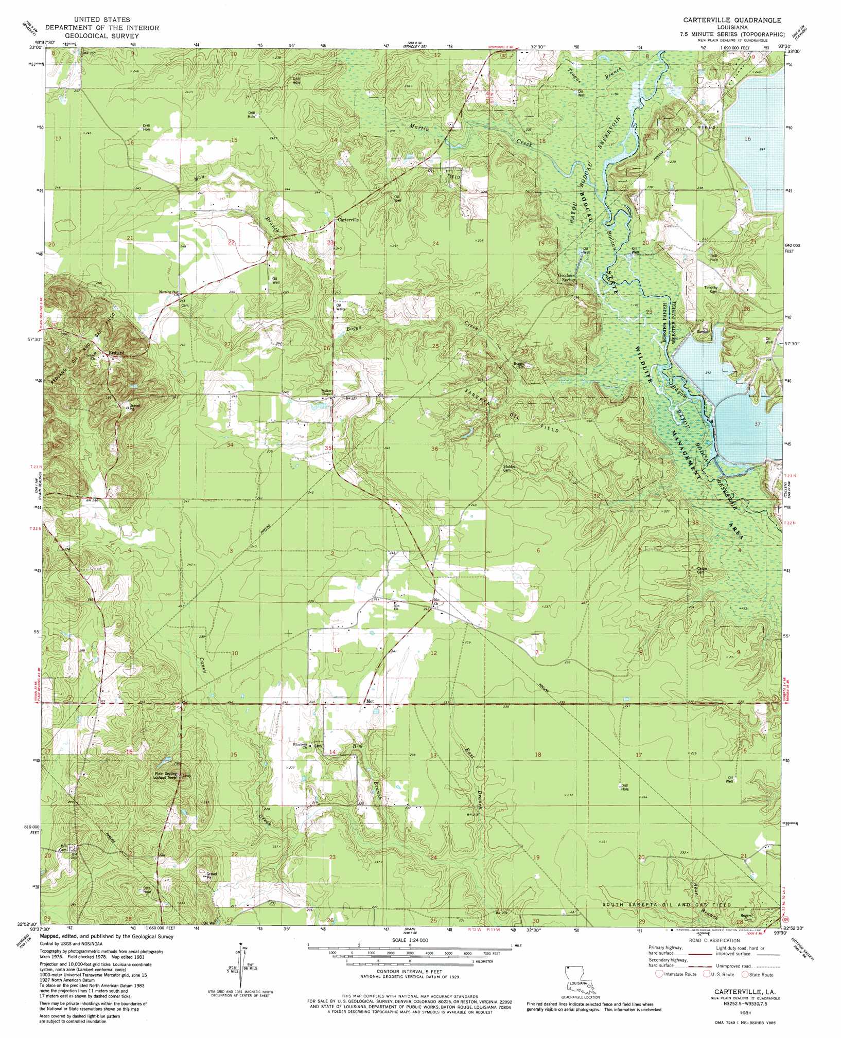
Carterville Topo Map Louisiana
To zoom in, hover over the map of Carterville
USGS Topo Quad 32093h5 - 1:24,000 scale
| Topo Map Name: | Carterville |
| USGS Topo Quad ID: | 32093h5 |
| Print Size: | ca. 21 1/4" wide x 27" high |
| Southeast Coordinates: | 32.875° N latitude / 93.5° W longitude |
| Map Center Coordinates: | 32.9375° N latitude / 93.5625° W longitude |
| U.S. State: | LA |
| Filename: | o32093h5.jpg |
| Download Map JPG Image: | Carterville topo map 1:24,000 scale |
| Map Type: | Topographic |
| Topo Series: | 7.5´ |
| Map Scale: | 1:24,000 |
| Source of Map Images: | United States Geological Survey (USGS) |
| Alternate Map Versions: |
Carterville LA 1953, updated 1954 Download PDF Buy paper map Carterville LA 1981, updated 1981 Download PDF Buy paper map Carterville LA 2012 Download PDF Buy paper map Carterville LA 2015 Download PDF Buy paper map |
1:24,000 Topo Quads surrounding Carterville
Doddridge Ne |
Canfield |
Bradley Ne |
Bussey |
Macedonia |
Doddridge Se |
Bradley |
Bradley Se |
Taylor |
Walkerville |
Wardview |
Plain Dealing |
Carterville |
Cullen |
Shongaloo |
Gilliam |
Hughes |
Ivan |
Cotton Valley |
Leton |
Dixie |
Benton |
Bodcau Lake |
Hortman |
Minden North |
> Back to 32093e1 at 1:100,000 scale
> Back to 32092a1 at 1:250,000 scale
> Back to U.S. Topo Maps home
Carterville topo map: Gazetteer
Carterville: Dams
Murray Lake Annex Dam elevation 69m 226′Carterville: Oilfields
Sarepta Oil Field elevation 70m 229′Carterville: Populated Places
Carterville elevation 75m 246′Mot elevation 73m 239′
Redland elevation 116m 380′
Timothy (historical) elevation 72m 236′
Carterville: Springs
Goodwin Spring elevation 65m 213′Carterville: Streams
Boggs Creek elevation 58m 190′Dooley Creek elevation 63m 206′
Dooley Creek elevation 63m 206′
East Branch Caney Creek elevation 64m 209′
Hog Branch elevation 65m 213′
Martin Creek elevation 59m 193′
Martin Creek elevation 59m 193′
May Branch elevation 66m 216′
Teague Branch elevation 59m 193′
Carterville digital topo map on disk
Buy this Carterville topo map showing relief, roads, GPS coordinates and other geographical features, as a high-resolution digital map file on DVD: