Plain Dealing Topo Map Louisiana
To zoom in, hover over the map of Plain Dealing
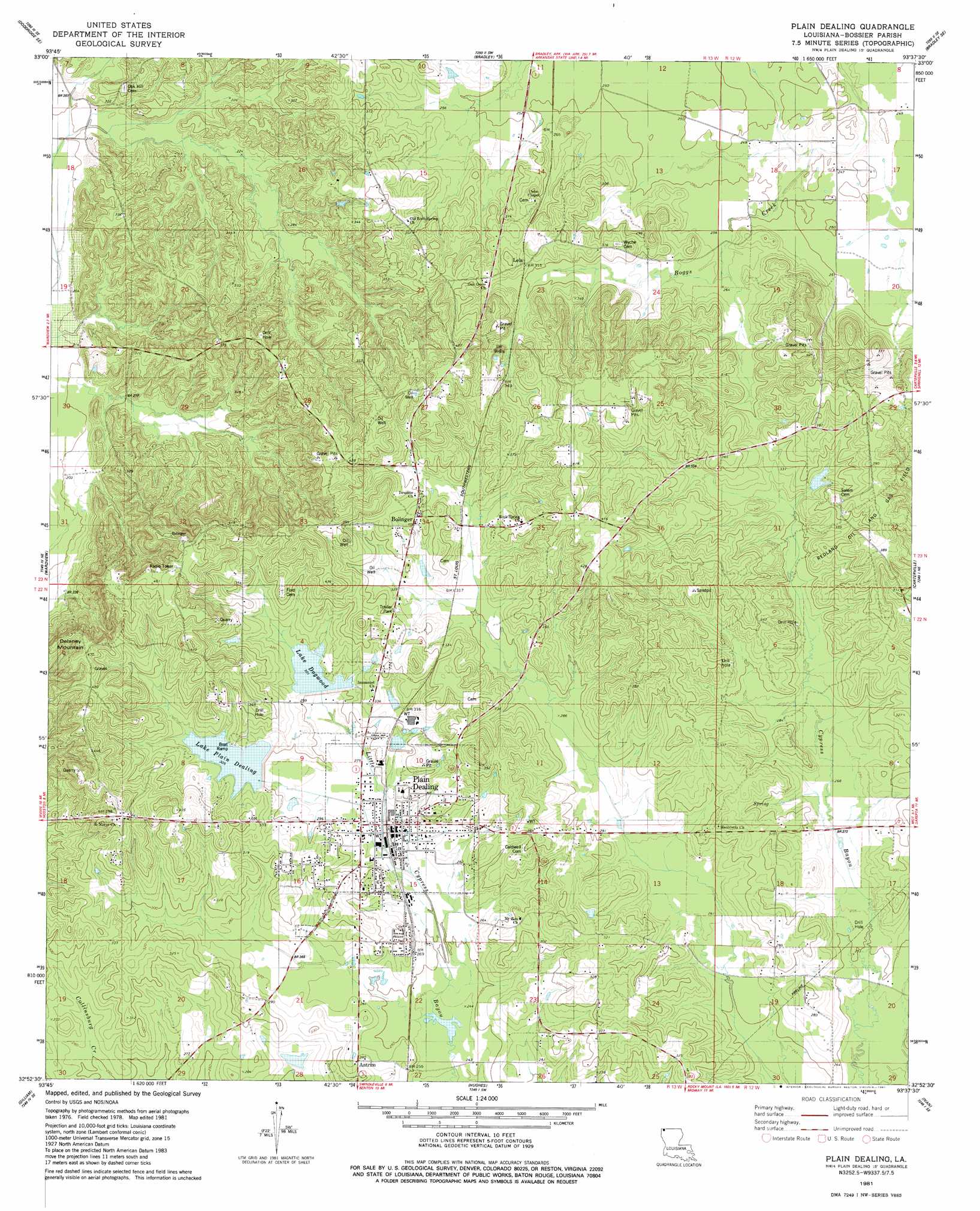
USGS Topo Quad 32093h6 - 1:24,000 scale
| Topo Map Name: | Plain Dealing |
| USGS Topo Quad ID: | 32093h6 |
| Print Size: | ca. 21 1/4" wide x 27" high |
| Southeast Coordinates: | 32.875° N latitude / 93.625° W longitude |
| Map Center Coordinates: | 32.9375° N latitude / 93.6875° W longitude |
| U.S. State: | LA |
| Filename: | o32093h6.jpg |
| Download Map JPG Image: | Plain Dealing topo map 1:24,000 scale |
| Map Type: | Topographic |
| Topo Series: | 7.5´ |
| Map Scale: | 1:24,000 |
| Source of Map Images: | United States Geological Survey (USGS) |
| Alternate Map Versions: |
Plain Dealing LA 1981, updated 1981 Download PDF Buy paper map Plain Dealing LA 2012 Download PDF Buy paper map Plain Dealing LA 2015 Download PDF Buy paper map |
1:24,000 Topo Quads surrounding Plain Dealing
Doddridge Nw |
Doddridge Ne |
Canfield |
Bradley Ne |
Bussey |
Doddridge |
Doddridge Se |
Bradley |
Bradley Se |
Taylor |
Vivian North |
Wardview |
Plain Dealing |
Carterville |
Cullen |
Vivian South |
Gilliam |
Hughes |
Ivan |
Cotton Valley |
Mooringsport |
Dixie |
Benton |
Bodcau Lake |
Hortman |
> Back to 32093e1 at 1:100,000 scale
> Back to 32092a1 at 1:250,000 scale
> Back to U.S. Topo Maps home
Plain Dealing topo map: Gazetteer
Plain Dealing: Dams
Cypress Bayou Number One Dam elevation 86m 282′Cypress Bayou Number Three Dam elevation 87m 285′
Cypress Bayou Number Two Dam elevation 87m 285′
Plain Dealing Lake Number Two Dam elevation 96m 314′
Plain Dealing Lake Site Number One Dam elevation 91m 298′
Plain Dealing: Oilfields
Bolinger Oil Field elevation 113m 370′Plain Dealing Oil Field elevation 114m 374′
Redland Oil and Gas Field elevation 123m 403′
Plain Dealing: Populated Places
Antrim elevation 85m 278′Bolinger elevation 109m 357′
Lela elevation 96m 314′
Plain Dealing elevation 80m 262′
Plain Dealing: Reservoirs
Cypress Bayou Number One elevation 86m 282′Cypress Bayou Number Three elevation 87m 285′
Cypress Bayou Number Two elevation 87m 285′
Lake Dogwood elevation 92m 301′
Lake Plain Dealing elevation 96m 314′
Plain Dealing: Summits
Delaney Mount elevation 139m 456′Plain Dealing digital topo map on disk
Buy this Plain Dealing topo map showing relief, roads, GPS coordinates and other geographical features, as a high-resolution digital map file on DVD: