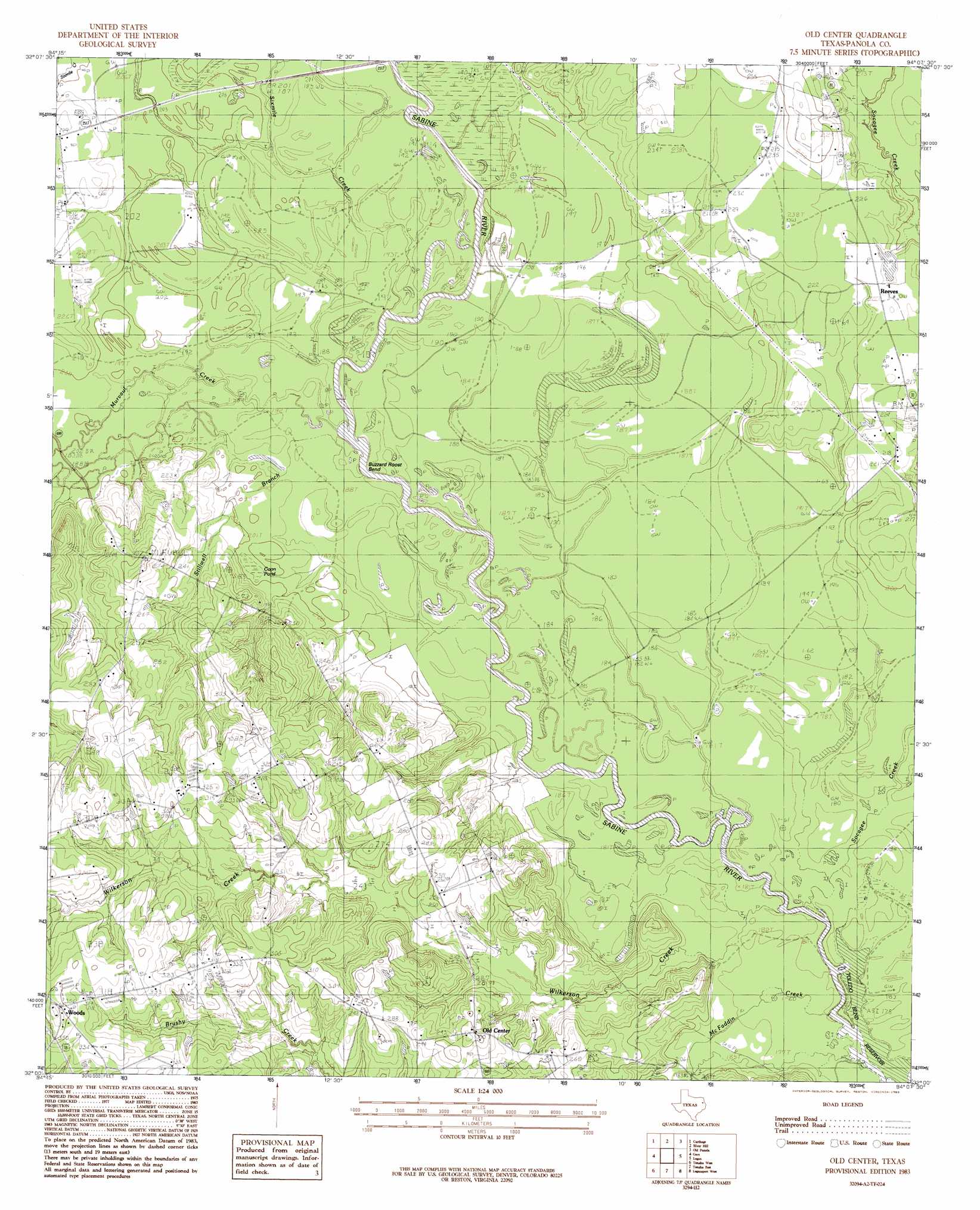
Old Center Topo Map Texas
To zoom in, hover over the map of Old Center
USGS Topo Quad 32094a2 - 1:24,000 scale
| Topo Map Name: | Old Center |
| USGS Topo Quad ID: | 32094a2 |
| Print Size: | ca. 21 1/4" wide x 27" high |
| Southeast Coordinates: | 32° N latitude / 94.125° W longitude |
| Map Center Coordinates: | 32.0625° N latitude / 94.1875° W longitude |
| U.S. State: | TX |
| Filename: | o32094a2.jpg |
| Download Map JPG Image: | Old Center topo map 1:24,000 scale |
| Map Type: | Topographic |
| Topo Series: | 7.5´ |
| Map Scale: | 1:24,000 |
| Source of Map Images: | United States Geological Survey (USGS) |
| Alternate Map Versions: |
Old Center TX 1983, updated 1983 Download PDF Buy paper map Old Center TX 2010 Download PDF Buy paper map Old Center TX 2013 Download PDF Buy paper map Old Center TX 2016 Download PDF Buy paper map |
1:24,000 Topo Quads surrounding Old Center
Harris Chapel |
Grand Bluff |
De Berry |
Panola |
Spring Ridge |
Beckville |
Carthage |
River Hill |
Old Panola |
Keatchie |
Lake Murvaul |
Gary |
Old Center |
Galloway |
Longstreet |
Timpson |
Tenaha West |
Tenaha East |
Logansport West |
Logansport East |
Garrison East |
Arcadia |
Center |
Shelbyville |
Huxley |
> Back to 32094a1 at 1:100,000 scale
> Back to 32094a1 at 1:250,000 scale
> Back to U.S. Topo Maps home
Old Center topo map: Gazetteer
Old Center: Bends
Buzzard Roost Bend elevation 59m 193′Old Center: Dams
Bounds Lake Dam elevation 66m 216′Old Center: Lakes
Coon Pond elevation 61m 200′Old Center: Populated Places
Old Center elevation 91m 298′Old Center elevation 89m 291′
Woods elevation 109m 357′
Old Center: Reservoirs
Toledo Bend Reservoir elevation 52m 170′Old Center: Streams
McFaddin Creek elevation 55m 180′Murvaul Creek elevation 55m 180′
Sixmile Creek elevation 55m 180′
Socagee Creek elevation 53m 173′
Wilkerson Creek elevation 55m 180′
Old Center digital topo map on disk
Buy this Old Center topo map showing relief, roads, GPS coordinates and other geographical features, as a high-resolution digital map file on DVD: