Lake Murvaul Topo Map Texas
To zoom in, hover over the map of Lake Murvaul
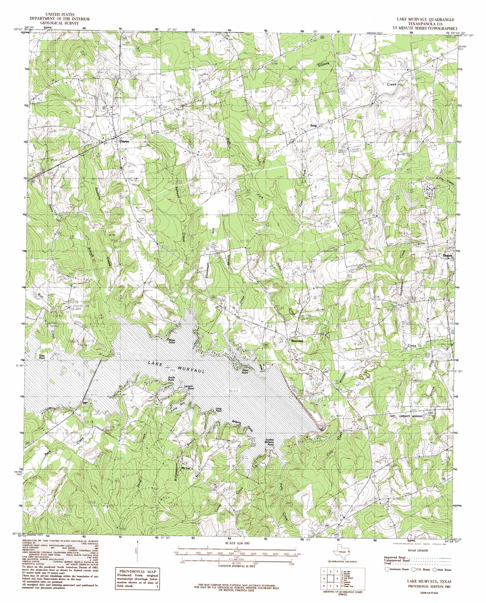
USGS Topo Quad 32094a4 - 1:24,000 scale
| Topo Map Name: | Lake Murvaul |
| USGS Topo Quad ID: | 32094a4 |
| Print Size: | ca. 21 1/4" wide x 27" high |
| Southeast Coordinates: | 32° N latitude / 94.375° W longitude |
| Map Center Coordinates: | 32.0625° N latitude / 94.4375° W longitude |
| U.S. State: | TX |
| Filename: | o32094a4.jpg |
| Download Map JPG Image: | Lake Murvaul topo map 1:24,000 scale |
| Map Type: | Topographic |
| Topo Series: | 7.5´ |
| Map Scale: | 1:24,000 |
| Source of Map Images: | United States Geological Survey (USGS) |
| Alternate Map Versions: |
Lake Murvaul TX 1983, updated 1983 Download PDF Buy paper map Lake Murvaul TX 2010 Download PDF Buy paper map Lake Murvaul TX 2013 Download PDF Buy paper map Lake Murvaul TX 2016 Download PDF Buy paper map |
1:24,000 Topo Quads surrounding Lake Murvaul
Elderville |
Tatum |
Harris Chapel |
Grand Bluff |
De Berry |
Church Hill |
Fair Play |
Beckville |
Carthage |
River Hill |
Minden |
Long Branch |
Lake Murvaul |
Gary |
Old Center |
Mount Enterprise |
Caledonia |
Timpson |
Tenaha West |
Tenaha East |
Trawick |
Garrison West |
Garrison East |
Arcadia |
Center |
> Back to 32094a1 at 1:100,000 scale
> Back to 32094a1 at 1:250,000 scale
> Back to U.S. Topo Maps home
Lake Murvaul topo map: Gazetteer
Lake Murvaul: Bays
Long Bay elevation 81m 265′Lake Murvaul: Capes
Dudley Williams Point elevation 84m 275′Gray Point elevation 82m 269′
Lampin Point elevation 83m 272′
Long Point elevation 81m 265′
Moss Point elevation 82m 269′
Ritter Point elevation 81m 265′
Smith Point elevation 86m 282′
Williams Point elevation 82m 269′
Lake Murvaul: Dams
Murvaul Bayou Dam elevation 81m 265′Panola Lake Dam elevation 94m 308′
Lake Murvaul: Populated Places
Buncome elevation 90m 295′Clayton elevation 118m 387′
Daniels elevation 96m 314′
Lake Murvaul: Reservoirs
Lake Murvaul elevation 81m 265′Murvaul Bayou Reservoir elevation 81m 265′
Panola Lake elevation 94m 308′
Lake Murvaul: Streams
Beck Creek elevation 85m 278′Beck Creek elevation 82m 269′
Bull Creek elevation 81m 265′
Caney Creek elevation 81m 265′
Colo Creek elevation 73m 239′
Daniels Ditch elevation 69m 226′
Davis Branch elevation 81m 265′
East Fork Indian Creek elevation 86m 282′
Fallwell Creek elevation 81m 265′
Holly Creek elevation 81m 265′
Indian Creek elevation 69m 226′
Jones Branch elevation 81m 265′
Sand Creek elevation 81m 265′
Sessums Creek elevation 81m 265′
Stephenson Creek elevation 70m 229′
West Fork Indian Creek elevation 85m 278′
Witherspoon Branch elevation 81m 265′
Lake Murvaul: Summits
Stonewall Hill elevation 97m 318′Lake Murvaul digital topo map on disk
Buy this Lake Murvaul topo map showing relief, roads, GPS coordinates and other geographical features, as a high-resolution digital map file on DVD: