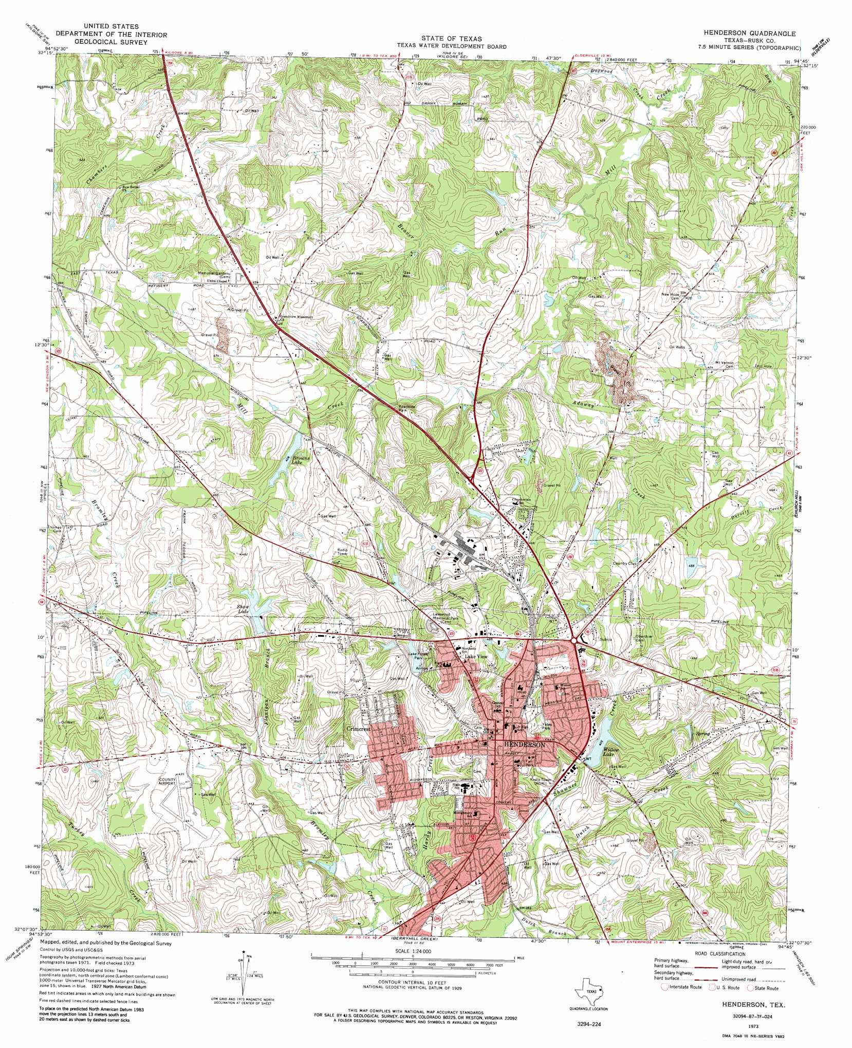
Henderson Topo Map Texas
To zoom in, hover over the map of Henderson
USGS Topo Quad 32094b7 - 1:24,000 scale
| Topo Map Name: | Henderson |
| USGS Topo Quad ID: | 32094b7 |
| Print Size: | ca. 21 1/4" wide x 27" high |
| Southeast Coordinates: | 32.125° N latitude / 94.75° W longitude |
| Map Center Coordinates: | 32.1875° N latitude / 94.8125° W longitude |
| U.S. State: | TX |
| Filename: | o32094b7.jpg |
| Download Map JPG Image: | Henderson topo map 1:24,000 scale |
| Map Type: | Topographic |
| Topo Series: | 7.5´ |
| Map Scale: | 1:24,000 |
| Source of Map Images: | United States Geological Survey (USGS) |
| Alternate Map Versions: |
Henderson TX 1973, updated 1975 Download PDF Buy paper map Henderson TX 1973, updated 1985 Download PDF Buy paper map Henderson TX 2010 Download PDF Buy paper map Henderson TX 2013 Download PDF Buy paper map Henderson TX 2016 Download PDF Buy paper map |
1:24,000 Topo Quads surrounding Henderson
Starrville |
Kilgore Nw |
Kilgore Ne |
Lakeport |
Easton |
Hope Pond |
Kilgore Sw |
Kilgore Se |
Elderville |
Tatum |
Troup East |
Price |
Henderson |
Church Hill |
Fair Play |
Griffin |
Gum Springs |
Berryhill Creek |
Minden |
Long Branch |
New Summerfield |
New Salem |
Laneville |
Mount Enterprise |
Caledonia |
> Back to 32094a1 at 1:100,000 scale
> Back to 32094a1 at 1:250,000 scale
> Back to U.S. Topo Maps home
Henderson topo map: Gazetteer
Henderson: Airports
Rusk County Airport elevation 134m 439′Henderson: Dams
Browns Lake Railroad Embankment Dam elevation 125m 410′Felix Cook Dam elevation 107m 351′
Lake Forrest Dam elevation 127m 416′
Shaw Lake Dam elevation 134m 439′
Sportsmans Lake Dam elevation 125m 410′
Wiley Webb Lake Dam elevation 115m 377′
Willow Lake Dam elevation 123m 403′
Henderson: Parks
Fair Park elevation 135m 442′Lake Forest Park elevation 138m 452′
Yates Park elevation 136m 446′
Henderson: Populated Places
Crimcrest elevation 149m 488′Henderson elevation 156m 511′
Lake View elevation 148m 485′
Henderson: Reservoirs
Browns Lake elevation 125m 410′Felix Cook Reservoir elevation 107m 351′
Lake Forrest elevation 127m 416′
Shaw Lake elevation 131m 429′
Sportsmans Lake elevation 125m 410′
Wiley Webb Lake elevation 115m 377′
Willow Lake elevation 125m 410′
Henderson: Streams
Adaway Creek elevation 110m 360′Beaver Run elevation 104m 341′
Dogwood Creek elevation 101m 331′
Dutch Branch elevation 119m 390′
Dutch Creek elevation 117m 383′
Flanigan Branch elevation 119m 390′
Hardy Creek elevation 113m 370′
Henderson digital topo map on disk
Buy this Henderson topo map showing relief, roads, GPS coordinates and other geographical features, as a high-resolution digital map file on DVD: