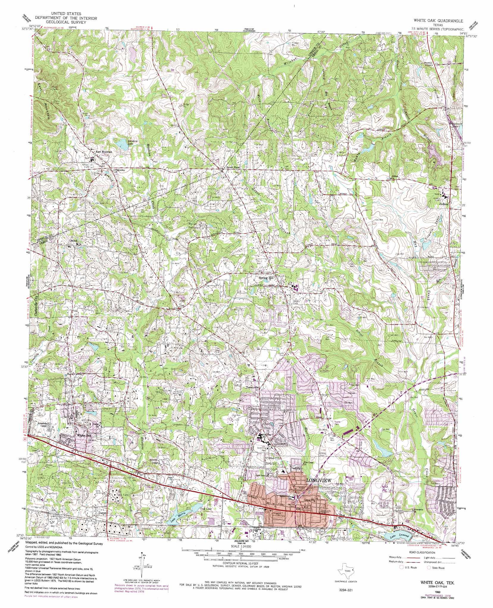
White Oak Topo Map Texas
To zoom in, hover over the map of White Oak
USGS Topo Quad 32094e7 - 1:24,000 scale
| Topo Map Name: | White Oak |
| USGS Topo Quad ID: | 32094e7 |
| Print Size: | ca. 21 1/4" wide x 27" high |
| Southeast Coordinates: | 32.5° N latitude / 94.75° W longitude |
| Map Center Coordinates: | 32.5625° N latitude / 94.8125° W longitude |
| U.S. State: | TX |
| Filename: | o32094e7.jpg |
| Download Map JPG Image: | White Oak topo map 1:24,000 scale |
| Map Type: | Topographic |
| Topo Series: | 7.5´ |
| Map Scale: | 1:24,000 |
| Source of Map Images: | United States Geological Survey (USGS) |
| Alternate Map Versions: |
White Oak TX 1960, updated 1962 Download PDF Buy paper map White Oak TX 1960, updated 1978 Download PDF Buy paper map White Oak TX 1960, updated 1992 Download PDF Buy paper map White Oak TX 2010 Download PDF Buy paper map White Oak TX 2013 Download PDF Buy paper map White Oak TX 2016 Download PDF Buy paper map |
1:24,000 Topo Quads surrounding White Oak
Thomas |
Bettie |
Coffeeville |
Ore City |
Lassater |
Pritchett |
Gilmer |
Glenwood |
Ashland |
Harleton |
Big Sandy |
Gladewater |
White Oak |
Longview Heights |
Hallsville |
Starrville |
Kilgore Nw |
Kilgore Ne |
Lakeport |
Easton |
Hope Pond |
Kilgore Sw |
Kilgore Se |
Elderville |
Tatum |
> Back to 32094e1 at 1:100,000 scale
> Back to 32094a1 at 1:250,000 scale
> Back to U.S. Topo Maps home
White Oak topo map: Gazetteer
White Oak: Dams
Dixon Farms Lake Dam elevation 111m 364′Forest Lake Dam elevation 111m 364′
Lake Harris Dam elevation 96m 314′
Landers Lake Dam elevation 118m 387′
Lomond Dam elevation 90m 295′
R and K Dam elevation 99m 324′
Stone Lake Dam elevation 112m 367′
White Oak: Oilfields
Arkansas Gasoline Plant elevation 116m 380′East Texas Oil Field elevation 116m 380′
White Oak: Parks
Jackson Park elevation 85m 278′Mc Whorter Park elevation 119m 390′
Pirate Stadium elevation 124m 406′
White Oak City Park elevation 103m 337′
White Oak: Populated Places
East Mountain elevation 131m 429′Judson elevation 130m 426′
Seven Pines elevation 134m 439′
Shiloh elevation 125m 410′
Spring Hill elevation 125m 410′
Teneryville elevation 129m 423′
White Oak elevation 126m 413′
White Oak: Reservoirs
Cook Lake elevation 101m 331′Dixon Farms Lake elevation 111m 364′
Forest Lake elevation 111m 364′
Lake Harris elevation 96m 314′
Lake Lamond elevation 91m 298′
Lake Lomond elevation 90m 295′
Landers Lake elevation 114m 374′
R and K Lake elevation 99m 324′
Stone Lake elevation 112m 367′
Virginia Lakes elevation 114m 374′
White Oak: Streams
Elm Branch elevation 99m 324′Flewelen Branch elevation 89m 291′
Hamby Branch elevation 97m 318′
Hog Branch elevation 96m 314′
Johnson Branch elevation 94m 308′
Loden Branch elevation 103m 337′
School Branch elevation 88m 288′
Wells Branch elevation 99m 324′
White Oak: Summits
East Mountain elevation 200m 656′White Oak digital topo map on disk
Buy this White Oak topo map showing relief, roads, GPS coordinates and other geographical features, as a high-resolution digital map file on DVD: