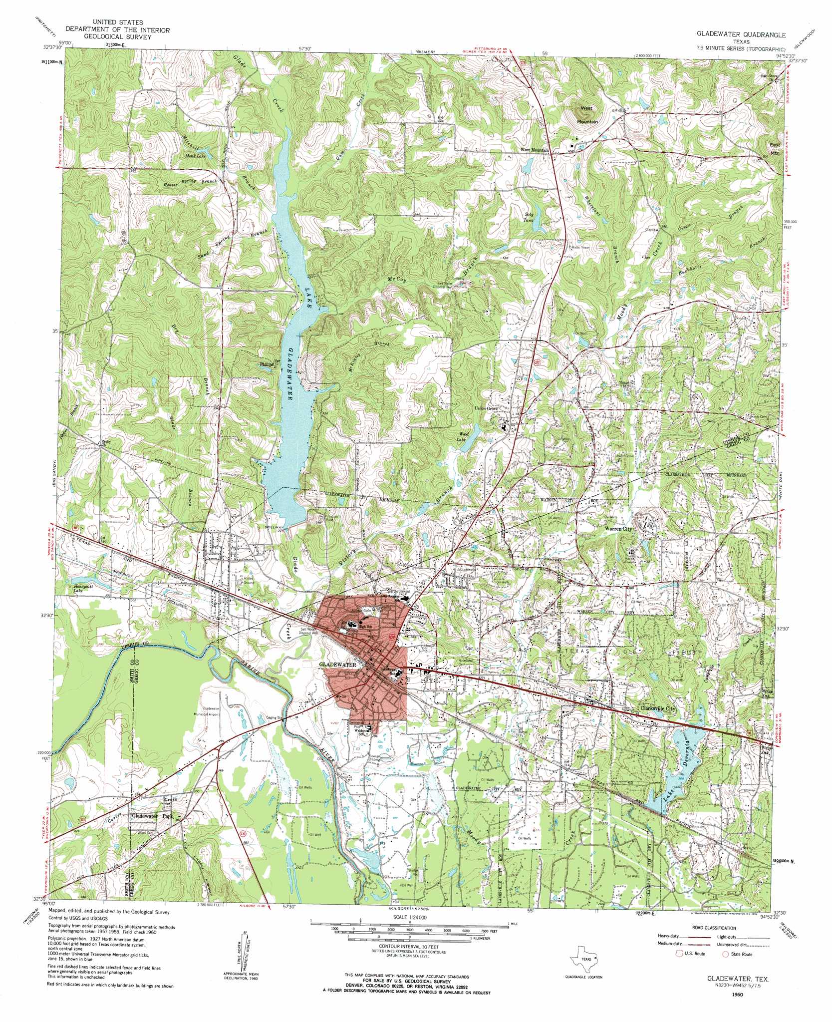
Gladewater Topo Map Texas
To zoom in, hover over the map of Gladewater
USGS Topo Quad 32094e8 - 1:24,000 scale
| Topo Map Name: | Gladewater |
| USGS Topo Quad ID: | 32094e8 |
| Print Size: | ca. 21 1/4" wide x 27" high |
| Southeast Coordinates: | 32.5° N latitude / 94.875° W longitude |
| Map Center Coordinates: | 32.5625° N latitude / 94.9375° W longitude |
| U.S. State: | TX |
| Filename: | o32094e8.jpg |
| Download Map JPG Image: | Gladewater topo map 1:24,000 scale |
| Map Type: | Topographic |
| Topo Series: | 7.5´ |
| Map Scale: | 1:24,000 |
| Source of Map Images: | United States Geological Survey (USGS) |
| Alternate Map Versions: |
Gladewater TX 1960, updated 1962 Download PDF Buy paper map Gladewater TX 1960, updated 1962 Download PDF Buy paper map Gladewater TX 2010 Download PDF Buy paper map Gladewater TX 2013 Download PDF Buy paper map Gladewater TX 2016 Download PDF Buy paper map |
1:24,000 Topo Quads surrounding Gladewater
Rhonesboro |
Thomas |
Bettie |
Coffeeville |
Ore City |
Shady Grove |
Pritchett |
Gilmer |
Glenwood |
Ashland |
Hawkins |
Big Sandy |
Gladewater |
White Oak |
Longview Heights |
Winona |
Starrville |
Kilgore Nw |
Kilgore Ne |
Lakeport |
Bascom |
Hope Pond |
Kilgore Sw |
Kilgore Se |
Elderville |
> Back to 32094e1 at 1:100,000 scale
> Back to 32094a1 at 1:250,000 scale
> Back to U.S. Topo Maps home
Gladewater topo map: Gazetteer
Gladewater: Airports
Gladewater Municipal Airport elevation 89m 291′Gladewater: Dams
Lake Deverina Dam elevation 88m 288′Lake Gladewater Dam elevation 86m 282′
Stroman Lake Dam elevation 102m 334′
Wood Lake Dam elevation 99m 324′
Gladewater: Lakes
Lake Devernia elevation 88m 288′Gladewater: Parks
Jack V Murphy Stadium elevation 101m 331′Gladewater: Populated Places
Clarksville City elevation 110m 360′Gladewater elevation 111m 364′
Gladewater Park elevation 108m 354′
Phillips elevation 98m 321′
Union Grove elevation 125m 410′
Warren City elevation 113m 370′
West Mountain elevation 136m 446′
Gladewater: Reservoirs
Honeycutt Lake elevation 86m 282′Lake Deverina elevation 88m 288′
Lake Gladewater elevation 87m 285′
Monk Lake elevation 101m 331′
Soby Tank elevation 114m 374′
Stroman Lake elevation 102m 334′
Wood Lake elevation 102m 334′
Gladewater: Streams
Buckholts Branch elevation 109m 357′Campbells Creek elevation 82m 269′
Carter Creek elevation 84m 275′
Clear Branch elevation 113m 370′
Dry Branch elevation 97m 318′
Glade Branch elevation 82m 269′
Glade Creek elevation 74m 242′
Gum Creek elevation 92m 301′
Hoover Spring Branch elevation 97m 318′
McCoy Branch elevation 93m 305′
Mitchell Branch elevation 94m 308′
Sand Spring Branch elevation 94m 308′
Victory Branch elevation 86m 282′
Whetstone Branch elevation 104m 341′
Gladewater: Summits
West Mountain elevation 191m 626′Gladewater digital topo map on disk
Buy this Gladewater topo map showing relief, roads, GPS coordinates and other geographical features, as a high-resolution digital map file on DVD: