Gilmer Topo Map Texas
To zoom in, hover over the map of Gilmer
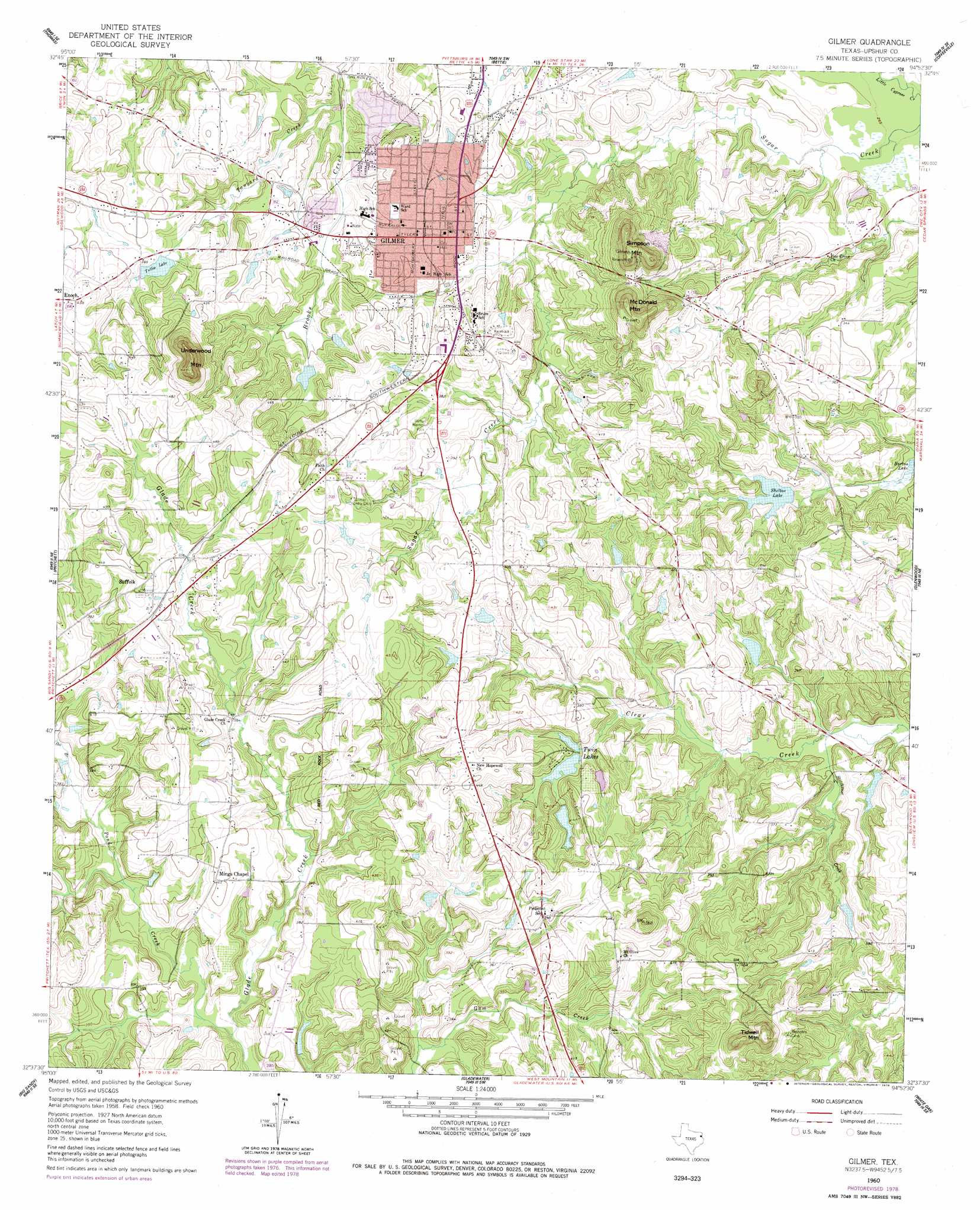
USGS Topo Quad 32094f8 - 1:24,000 scale
| Topo Map Name: | Gilmer |
| USGS Topo Quad ID: | 32094f8 |
| Print Size: | ca. 21 1/4" wide x 27" high |
| Southeast Coordinates: | 32.625° N latitude / 94.875° W longitude |
| Map Center Coordinates: | 32.6875° N latitude / 94.9375° W longitude |
| U.S. State: | TX |
| Filename: | o32094f8.jpg |
| Download Map JPG Image: | Gilmer topo map 1:24,000 scale |
| Map Type: | Topographic |
| Topo Series: | 7.5´ |
| Map Scale: | 1:24,000 |
| Source of Map Images: | United States Geological Survey (USGS) |
| Alternate Map Versions: |
Gilmer TX 1960, updated 1962 Download PDF Buy paper map Gilmer TX 1960, updated 1978 Download PDF Buy paper map Gilmer TX 2010 Download PDF Buy paper map Gilmer TX 2013 Download PDF Buy paper map Gilmer TX 2016 Download PDF Buy paper map |
1:24,000 Topo Quads surrounding Gilmer
Newsome |
Leesburg |
Pittsburg |
Lafayette |
Lone Star |
Rhonesboro |
Thomas |
Bettie |
Coffeeville |
Ore City |
Shady Grove |
Pritchett |
Gilmer |
Glenwood |
Ashland |
Hawkins |
Big Sandy |
Gladewater |
White Oak |
Longview Heights |
Winona |
Starrville |
Kilgore Nw |
Kilgore Ne |
Lakeport |
> Back to 32094e1 at 1:100,000 scale
> Back to 32094a1 at 1:250,000 scale
> Back to U.S. Topo Maps home
Gilmer topo map: Gazetteer
Gilmer: Airports
Gilmer-Upshur County Airport elevation 118m 387′Gilmer: Dams
Lindsey Lake Dam elevation 108m 354′Messner Lake Dam elevation 92m 301′
Nunn Lake Dam elevation 99m 324′
Safady Lake Dam elevation 114m 374′
Sheltons Lake Dam elevation 97m 318′
Sonny Oats Lake Number 1 Dam elevation 106m 347′
Sonny Oats Lake Number 2 Dam elevation 117m 383′
South Twin Lakes Dam elevation 105m 344′
Gilmer: Populated Places
Enoch elevation 133m 436′Gilmer elevation 112m 367′
Mings Chapel elevation 125m 410′
Pattonfield elevation 131m 429′
Piedmont elevation 120m 393′
Gilmer: Reservoirs
Lindsey Lake elevation 108m 354′Messner Lake elevation 92m 301′
Nunn Lake elevation 99m 324′
Safady Lake elevation 114m 374′
Shelton Lake elevation 100m 328′
Sheltons Lake elevation 97m 318′
Sonny Oats Lake Number 1 elevation 106m 347′
Sonny Oats Lake Number 2 elevation 117m 383′
South Twin Lakes elevation 105m 344′
Tallos Lake elevation 113m 370′
Twin Lakes elevation 105m 344′
Gilmer: Streams
Bee Branch elevation 103m 337′Pond Creek elevation 94m 308′
Stillhouse Creek elevation 88m 288′
Tanyard Creek elevation 91m 298′
Gilmer: Summits
McDonald Mountain elevation 181m 593′Simpson Mountain elevation 188m 616′
Tidwell Mountain elevation 191m 626′
Underwood Mountain elevation 204m 669′
Gilmer digital topo map on disk
Buy this Gilmer topo map showing relief, roads, GPS coordinates and other geographical features, as a high-resolution digital map file on DVD: