Athens Topo Map Texas
To zoom in, hover over the map of Athens
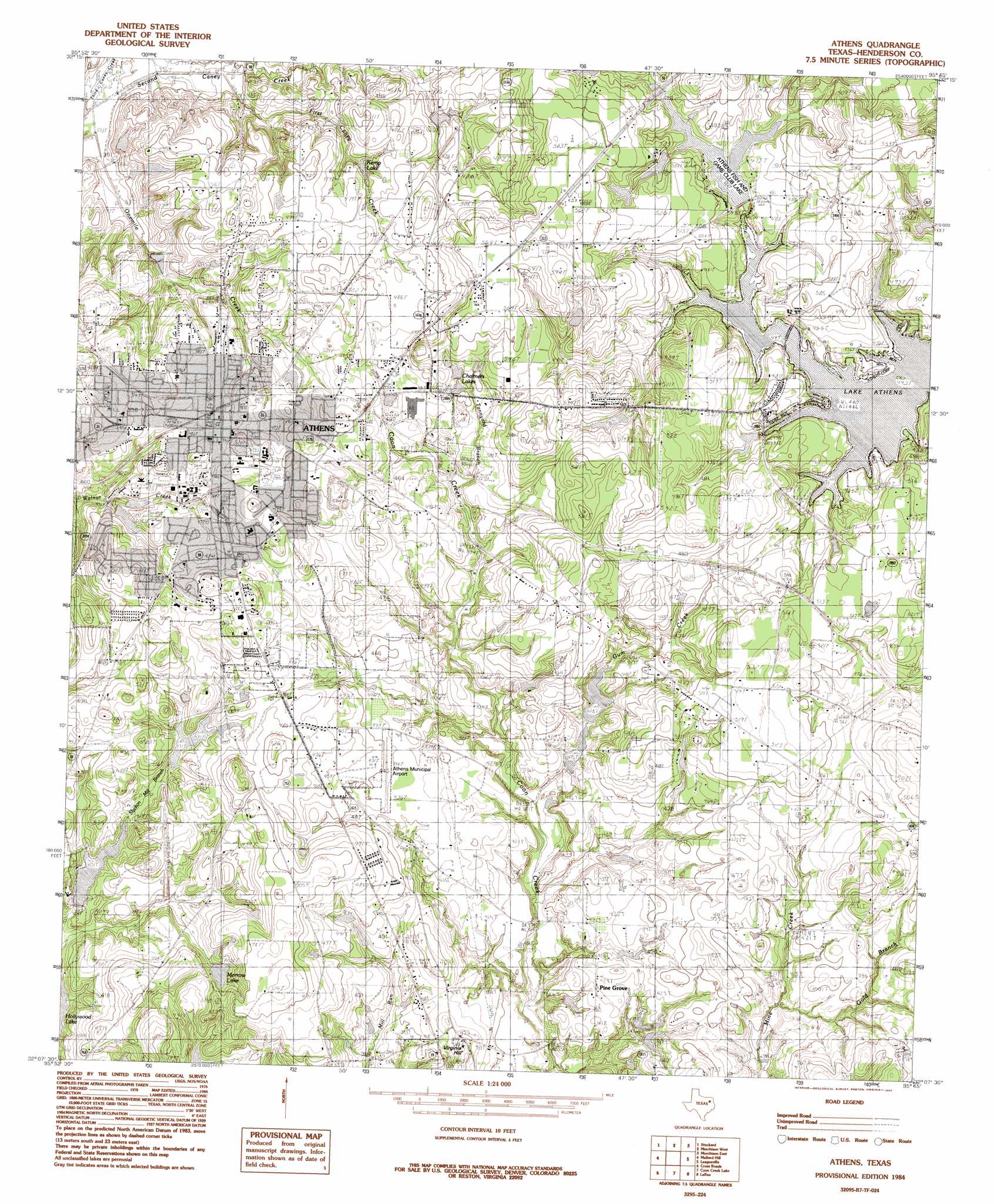
USGS Topo Quad 32095b7 - 1:24,000 scale
| Topo Map Name: | Athens |
| USGS Topo Quad ID: | 32095b7 |
| Print Size: | ca. 21 1/4" wide x 27" high |
| Southeast Coordinates: | 32.125° N latitude / 95.75° W longitude |
| Map Center Coordinates: | 32.1875° N latitude / 95.8125° W longitude |
| U.S. State: | TX |
| Filename: | o32095b7.jpg |
| Download Map JPG Image: | Athens topo map 1:24,000 scale |
| Map Type: | Topographic |
| Topo Series: | 7.5´ |
| Map Scale: | 1:24,000 |
| Source of Map Images: | United States Geological Survey (USGS) |
| Alternate Map Versions: |
Athens TX 1984, updated 1984 Download PDF Buy paper map Athens TX 1984, updated 1984 Download PDF Buy paper map Athens TX 2010 Download PDF Buy paper map Athens TX 2013 Download PDF Buy paper map Athens TX 2016 Download PDF Buy paper map |
1:24,000 Topo Quads surrounding Athens
Prairieville |
Phalba |
Martins Mill |
Ben Wheeler |
Carroll |
Mabank |
Stockard |
Murchinson West |
Murchinson East |
Brownsboro |
Malakoff |
Mallard Hill |
Athens |
Leagueville |
Moore Station |
Creslenn Ranch |
Cross Roads |
Coon Creek Lake |
La Rue |
Poynor |
Roustabout Camp |
Cayuga |
Blackfoot |
Wilkerson Mountain |
Pert |
> Back to 32095a1 at 1:100,000 scale
> Back to 32094a1 at 1:250,000 scale
> Back to U.S. Topo Maps home
Athens topo map: Gazetteer
Athens: Airports
Athens Municipal Airport elevation 137m 449′Athens: Dams
Adams Lake Dam elevation 129m 423′Athens Fish and Game Club Dam elevation 144m 472′
Darby Farms Lake Dam elevation 121m 396′
Moonshine Creek Dam Number 1 elevation 137m 449′
Moonshine Creek Dam Number 2 elevation 141m 462′
North Nichols Lake Dam elevation 127m 416′
Smith Lake Dam elevation 151m 495′
South Nichols Lake Dam elevation 123m 403′
Stroube Dam Number 2 elevation 128m 419′
Athens: Lakes
Chalmers Lake elevation 155m 508′Johnson Lake elevation 149m 488′
Kemp Lake elevation 136m 446′
Lake Athens elevation 134m 439′
Morrow Lake elevation 130m 426′
Athens: Parks
Athens City Park elevation 142m 465′Central Park elevation 145m 475′
Athens: Populated Places
Athens elevation 149m 488′Pine Grove elevation 128m 419′
Virginia Hill elevation 139m 456′
Athens: Reservoirs
Adams Lake elevation 129m 423′Athens Fish and Game Club Lake elevation 141m 462′
Darby Farms Lake elevation 121m 396′
Moonshine Creek Lake No1 elevation 137m 449′
Moonshine Creek Lake Number 2 elevation 141m 462′
North Nichols Lake elevation 127m 416′
Smith Lake elevation 151m 495′
South Nichols Lake elevation 123m 403′
Stroube Lake Number 2 elevation 128m 419′
Athens: Streams
Coppers Creek elevation 134m 439′First Caney Creek elevation 120m 393′
Gold Branch elevation 122m 400′
Athens digital topo map on disk
Buy this Athens topo map showing relief, roads, GPS coordinates and other geographical features, as a high-resolution digital map file on DVD: