Bascom Topo Map Texas
To zoom in, hover over the map of Bascom
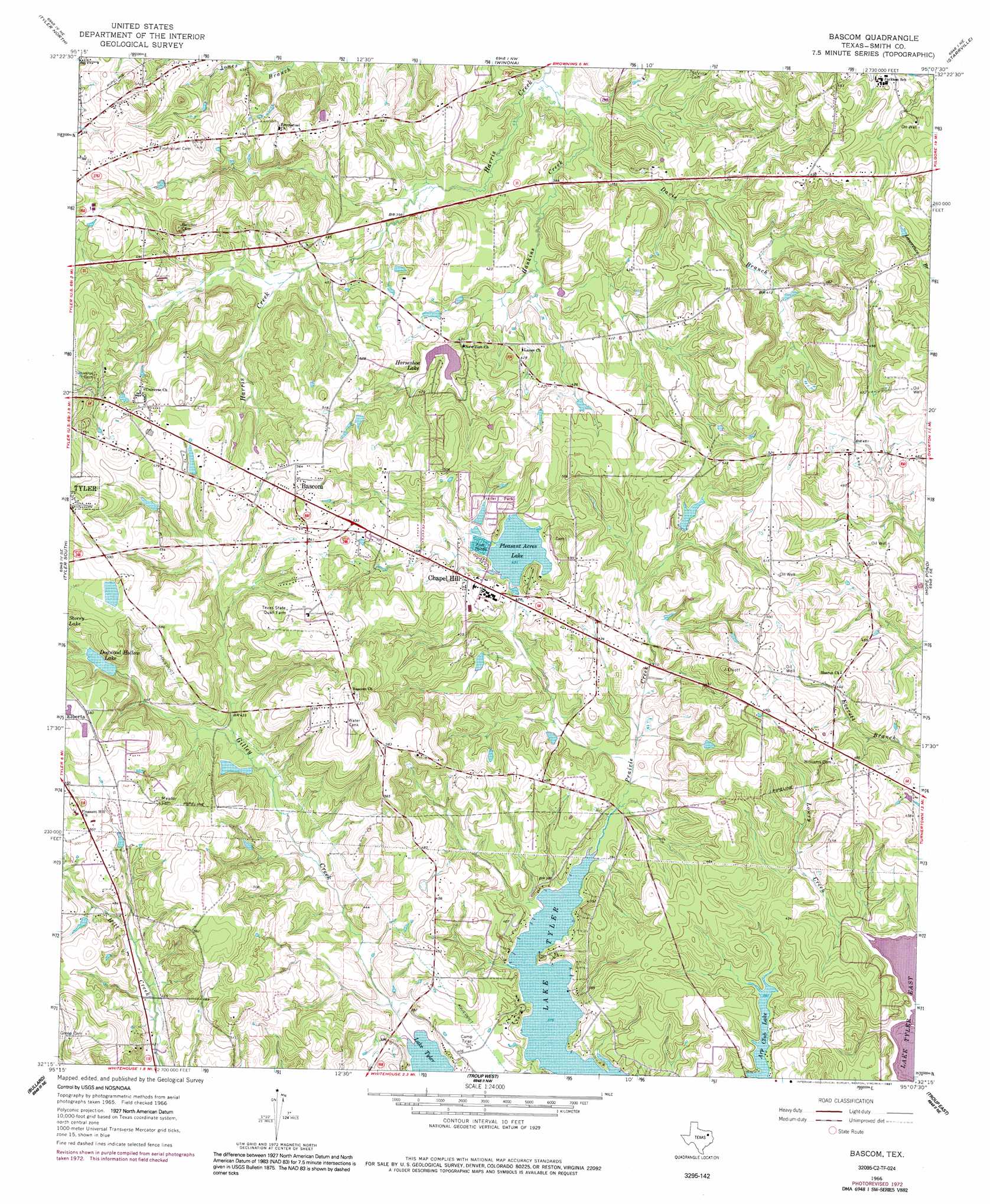
USGS Topo Quad 32095c2 - 1:24,000 scale
| Topo Map Name: | Bascom |
| USGS Topo Quad ID: | 32095c2 |
| Print Size: | ca. 21 1/4" wide x 27" high |
| Southeast Coordinates: | 32.25° N latitude / 95.125° W longitude |
| Map Center Coordinates: | 32.3125° N latitude / 95.1875° W longitude |
| U.S. State: | TX |
| Filename: | o32095c2.jpg |
| Download Map JPG Image: | Bascom topo map 1:24,000 scale |
| Map Type: | Topographic |
| Topo Series: | 7.5´ |
| Map Scale: | 1:24,000 |
| Source of Map Images: | United States Geological Survey (USGS) |
| Alternate Map Versions: |
Bascom TX 1966, updated 1969 Download PDF Buy paper map Bascom TX 1966, updated 1976 Download PDF Buy paper map Bascom TX 1966, updated 1991 Download PDF Buy paper map Bascom TX 2010 Download PDF Buy paper map Bascom TX 2012 Download PDF Buy paper map Bascom TX 2016 Download PDF Buy paper map |
1:24,000 Topo Quads surrounding Bascom
Lindale |
Crow |
Hawkins |
Big Sandy |
Gladewater |
Mount Sylvan |
Tyler North |
Winona |
Starrville |
Kilgore Nw |
Chandler |
Tyler South |
Bascom |
Hope Pond |
Kilgore Sw |
Saline Bay |
Bullard |
Troup West |
Troup East |
Price |
Berryville |
Mount Selman |
Tecula |
Griffin |
Gum Springs |
> Back to 32095a1 at 1:100,000 scale
> Back to 32094a1 at 1:250,000 scale
> Back to U.S. Topo Maps home
Bascom topo map: Gazetteer
Bascom: Airports
DPS-Tyler Heliport elevation 172m 564′Bascom: Dams
Arp Club Dam elevation 122m 400′Dogwood Hollow Lake Dam elevation 137m 449′
Horseshoe Club Lake Dam elevation 133m 436′
Pinkerton Lake Dam elevation 129m 423′
Pleasure Acres Lake Dam elevation 130m 426′
Bascom: Parks
Headache Springs Natural Park elevation 151m 495′Patriot Center elevation 188m 616′
Bascom: Populated Places
Bascom elevation 174m 570′Chapel Hill elevation 142m 465′
Elberta elevation 170m 557′
New Chapel Hill elevation 131m 429′
Bascom: Reservoirs
Dogwood Hollow Lake elevation 142m 465′Horseshoe Club Lake elevation 133m 436′
Horseshoe Lake elevation 133m 436′
Pinkerton Lake elevation 129m 423′
Pleasant Acres Lake elevation 130m 426′
Pleasure Acres Lake elevation 130m 426′
Bascom: Springs
Headache Springs elevation 165m 541′Bascom: Streams
Davis Branch elevation 113m 370′Hankins Creek elevation 111m 364′
Lowry Creek elevation 115m 377′
Bascom digital topo map on disk
Buy this Bascom topo map showing relief, roads, GPS coordinates and other geographical features, as a high-resolution digital map file on DVD: