Ben Wheeler Topo Map Texas
To zoom in, hover over the map of Ben Wheeler
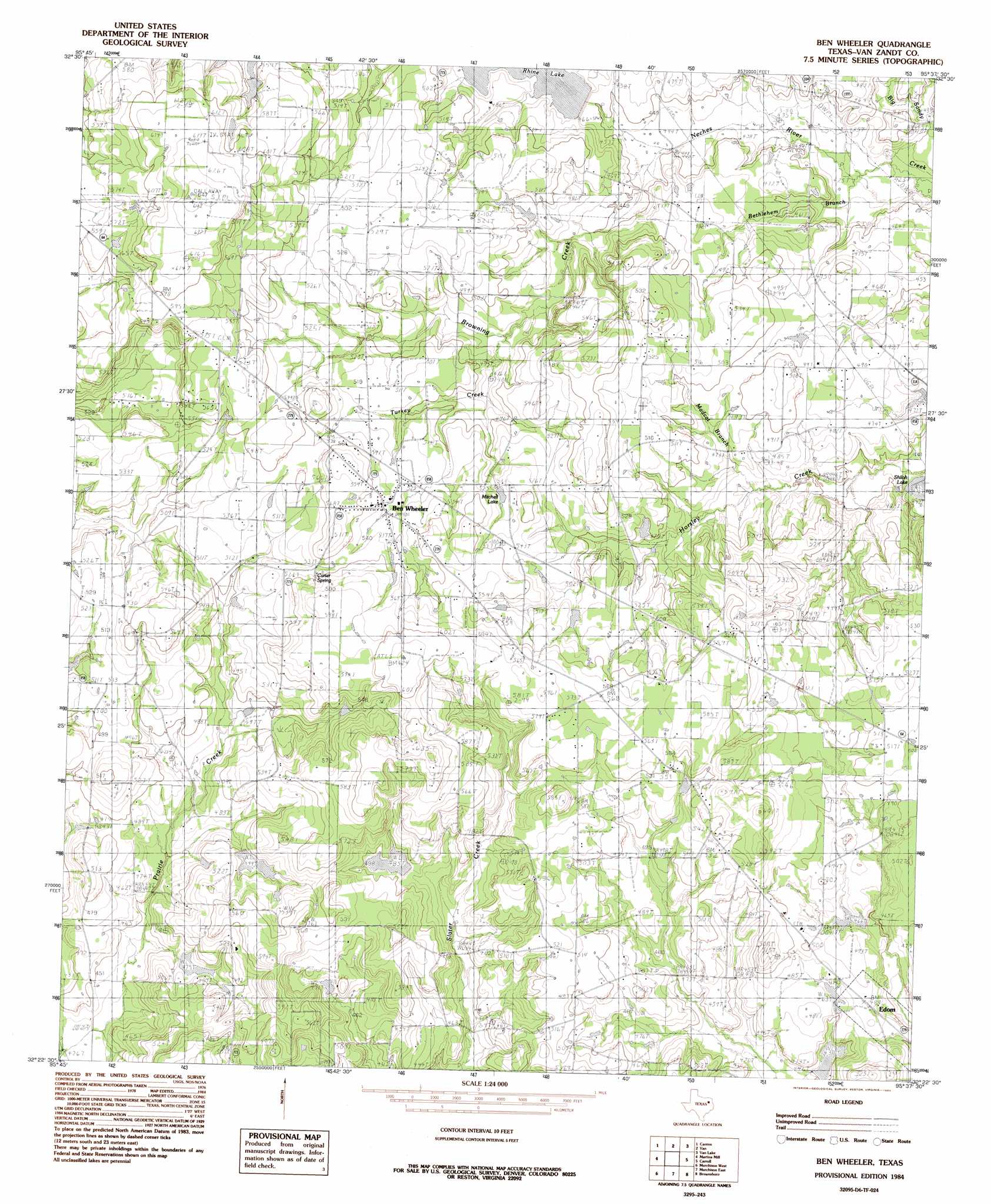
USGS Topo Quad 32095d6 - 1:24,000 scale
| Topo Map Name: | Ben Wheeler |
| USGS Topo Quad ID: | 32095d6 |
| Print Size: | ca. 21 1/4" wide x 27" high |
| Southeast Coordinates: | 32.375° N latitude / 95.625° W longitude |
| Map Center Coordinates: | 32.4375° N latitude / 95.6875° W longitude |
| U.S. State: | TX |
| Filename: | o32095d6.jpg |
| Download Map JPG Image: | Ben Wheeler topo map 1:24,000 scale |
| Map Type: | Topographic |
| Topo Series: | 7.5´ |
| Map Scale: | 1:24,000 |
| Source of Map Images: | United States Geological Survey (USGS) |
| Alternate Map Versions: |
Ben Wheeler TX 1984, updated 1984 Download PDF Buy paper map Ben Wheeler TX 2010 Download PDF Buy paper map Ben Wheeler TX 2013 Download PDF Buy paper map Ben Wheeler TX 2016 Download PDF Buy paper map |
1:24,000 Topo Quads surrounding Ben Wheeler
Edgewood |
Fruitvale |
Grand Saline |
Golden |
Mineola |
Myrtle Springs |
Canton |
Van |
Van Lake |
Lindale |
Phalba |
Martins Mill |
Ben Wheeler |
Carroll |
Mount Sylvan |
Stockard |
Murchinson West |
Murchinson East |
Brownsboro |
Chandler |
Mallard Hill |
Athens |
Leagueville |
Moore Station |
Saline Bay |
> Back to 32095a1 at 1:100,000 scale
> Back to 32094a1 at 1:250,000 scale
> Back to U.S. Topo Maps home
Ben Wheeler topo map: Gazetteer
Ben Wheeler: Dams
Cantrell Lake Dam elevation 142m 465′D W Smart Lake Dam elevation 139m 456′
Hand Lake Dam elevation 134m 439′
Payne Ranch Lake Dam elevation 147m 482′
Rhines Resevoir Dam elevation 142m 465′
Williams Lake Dam elevation 133m 436′
Ben Wheeler: Populated Places
Ben Wheeler elevation 162m 531′Ben Wheeler: Reservoirs
Cantrell Lake elevation 142m 465′Hand Lake elevation 134m 439′
Mitchell Lake elevation 162m 531′
Payne Ranch Lake elevation 147m 482′
Rhines Lake elevation 142m 465′
Smart Lake elevation 139m 456′
Ben Wheeler: Springs
Carter Spring elevation 167m 547′Ben Wheeler: Streams
Bethlehem Branch elevation 130m 426′Browning Creek elevation 134m 439′
Madcat Branch elevation 140m 459′
Prairie Creek elevation 131m 429′
Sour Branch elevation 139m 456′
Turkey Creek elevation 143m 469′
Ben Wheeler digital topo map on disk
Buy this Ben Wheeler topo map showing relief, roads, GPS coordinates and other geographical features, as a high-resolution digital map file on DVD: