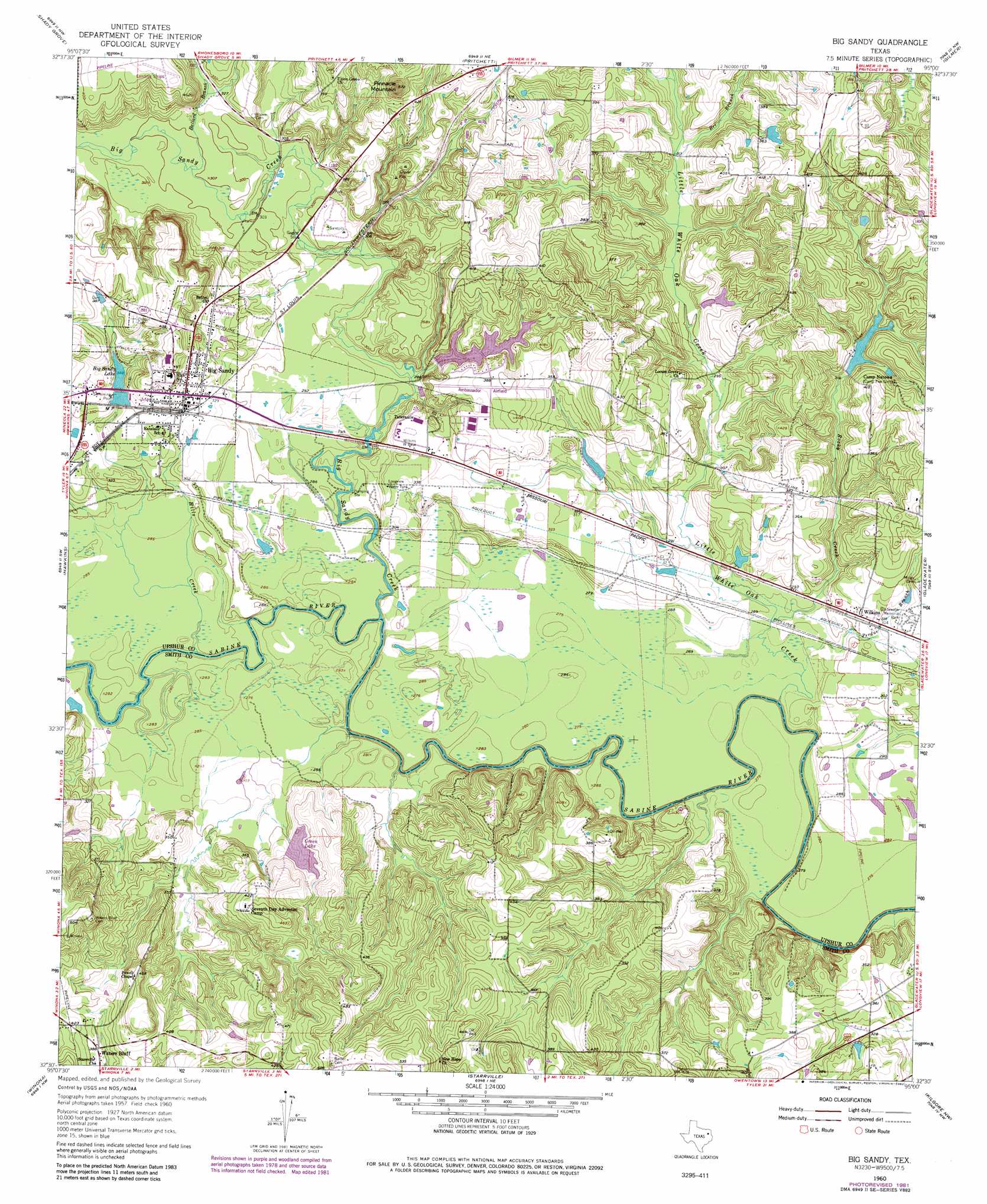
Big Sandy Topo Map Texas
To zoom in, hover over the map of Big Sandy
USGS Topo Quad 32095e1 - 1:24,000 scale
| Topo Map Name: | Big Sandy |
| USGS Topo Quad ID: | 32095e1 |
| Print Size: | ca. 21 1/4" wide x 27" high |
| Southeast Coordinates: | 32.5° N latitude / 95° W longitude |
| Map Center Coordinates: | 32.5625° N latitude / 95.0625° W longitude |
| U.S. State: | TX |
| Filename: | o32095e1.jpg |
| Download Map JPG Image: | Big Sandy topo map 1:24,000 scale |
| Map Type: | Topographic |
| Topo Series: | 7.5´ |
| Map Scale: | 1:24,000 |
| Source of Map Images: | United States Geological Survey (USGS) |
| Alternate Map Versions: |
Big Sandy TX 1960, updated 1961 Download PDF Buy paper map Big Sandy TX 1960, updated 1974 Download PDF Buy paper map Big Sandy TX 1960, updated 1982 Download PDF Buy paper map Big Sandy TX 2010 Download PDF Buy paper map Big Sandy TX 2012 Download PDF Buy paper map Big Sandy TX 2016 Download PDF Buy paper map |
1:24,000 Topo Quads surrounding Big Sandy
Cartwright |
Rhonesboro |
Thomas |
Bettie |
Coffeeville |
Hainesville |
Shady Grove |
Pritchett |
Gilmer |
Glenwood |
Crow |
Hawkins |
Big Sandy |
Gladewater |
White Oak |
Tyler North |
Winona |
Starrville |
Kilgore Nw |
Kilgore Ne |
Tyler South |
Bascom |
Hope Pond |
Kilgore Sw |
Kilgore Se |
> Back to 32095e1 at 1:100,000 scale
> Back to 32094a1 at 1:250,000 scale
> Back to U.S. Topo Maps home
Big Sandy topo map: Gazetteer
Big Sandy: Airports
Ambassador Field elevation 118m 387′Big Sandy: Dams
Ambassador College Reservoir Dam elevation 102m 334′Big Sandy Dam elevation 106m 347′
Gladewater Hunt and Fish Club Dam elevation 100m 328′
Green Lake Dam elevation 109m 357′
Longview Big Sandy Dam elevation 88m 288′
Renshaw Lake Dam elevation 108m 354′
Reynolds Lake Dam elevation 111m 364′
Big Sandy: Parks
Gladewater Memorial Park elevation 100m 328′Big Sandy: Populated Places
Big Sandy elevation 112m 367′Center Point elevation 128m 419′
Waters Bluff elevation 114m 374′
Wilkins elevation 95m 311′
Big Sandy: Reservoirs
Ambassador College Reservoir elevation 102m 334′Big Sandy Lake elevation 107m 351′
Gladewater Hunt and Fish Club Lake elevation 100m 328′
Green Lake elevation 109m 357′
Longview Big Sandy Reservoir elevation 88m 288′
Longview Water Tank elevation 104m 341′
Renshaw Lake elevation 108m 354′
Reynolds Lake elevation 111m 364′
Big Sandy: Streams
Ballard Branch elevation 91m 298′Bee Branch elevation 94m 308′
Big Sandy Creek elevation 81m 265′
Hills Creek elevation 83m 272′
Little White Oak Creek elevation 82m 269′
Perdue Branch elevation 83m 272′
Rocky Creek elevation 84m 275′
Big Sandy: Summits
Pinnacle Mountain elevation 170m 557′Big Sandy digital topo map on disk
Buy this Big Sandy topo map showing relief, roads, GPS coordinates and other geographical features, as a high-resolution digital map file on DVD: