Crow Topo Map Texas
To zoom in, hover over the map of Crow
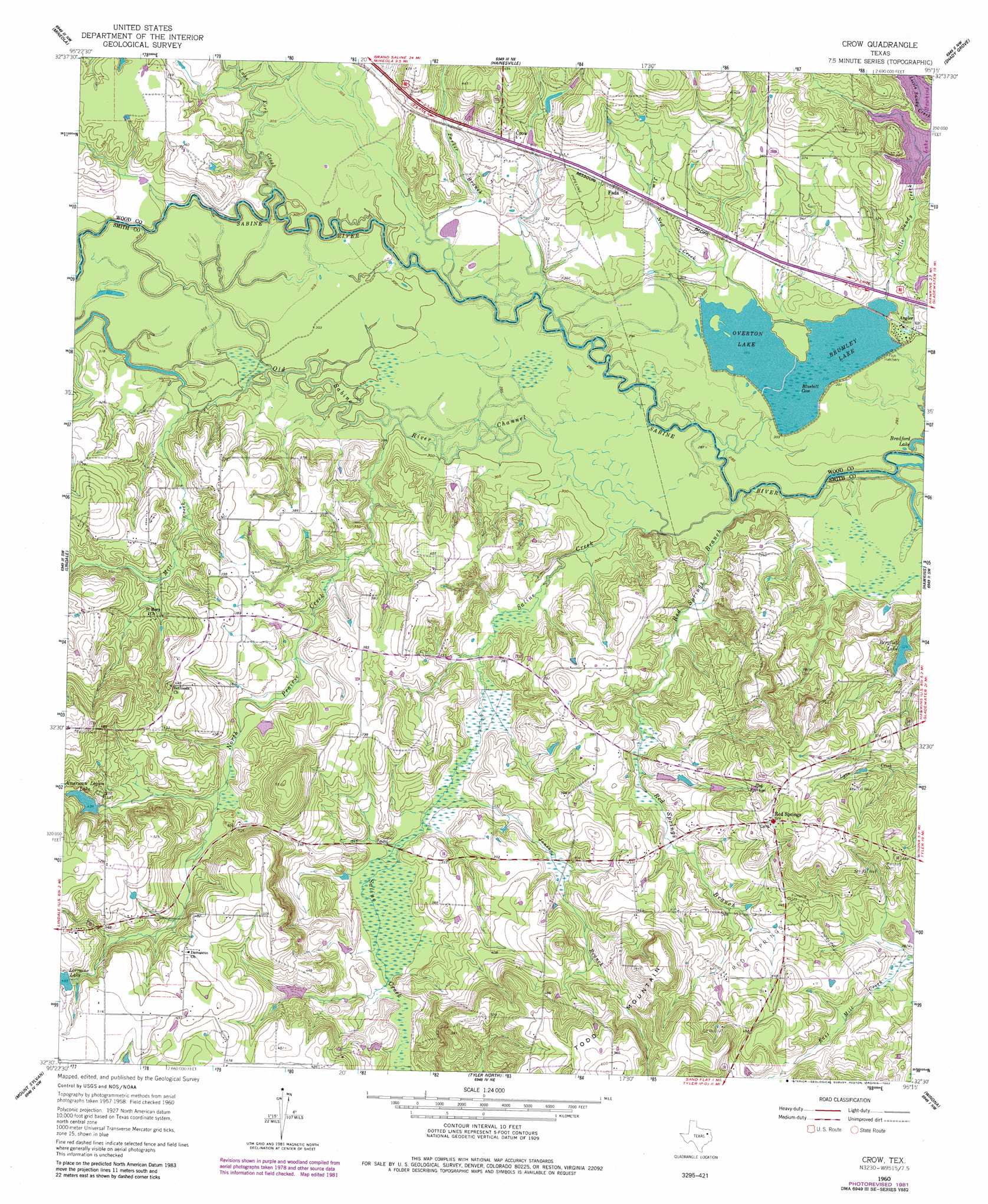
USGS Topo Quad 32095e3 - 1:24,000 scale
| Topo Map Name: | Crow |
| USGS Topo Quad ID: | 32095e3 |
| Print Size: | ca. 21 1/4" wide x 27" high |
| Southeast Coordinates: | 32.5° N latitude / 95.25° W longitude |
| Map Center Coordinates: | 32.5625° N latitude / 95.3125° W longitude |
| U.S. State: | TX |
| Filename: | o32095e3.jpg |
| Download Map JPG Image: | Crow topo map 1:24,000 scale |
| Map Type: | Topographic |
| Topo Series: | 7.5´ |
| Map Scale: | 1:24,000 |
| Source of Map Images: | United States Geological Survey (USGS) |
| Alternate Map Versions: |
Crow TX 1960, updated 1962 Download PDF Buy paper map Crow TX 1960, updated 1982 Download PDF Buy paper map Crow TX 2010 Download PDF Buy paper map Crow TX 2012 Download PDF Buy paper map Crow TX 2016 Download PDF Buy paper map |
1:24,000 Topo Quads surrounding Crow
Calvary |
Quitman |
Cartwright |
Rhonesboro |
Thomas |
Golden |
Mineola |
Hainesville |
Shady Grove |
Pritchett |
Van Lake |
Lindale |
Crow |
Hawkins |
Big Sandy |
Carroll |
Mount Sylvan |
Tyler North |
Winona |
Starrville |
Brownsboro |
Chandler |
Tyler South |
Bascom |
Hope Pond |
> Back to 32095e1 at 1:100,000 scale
> Back to 32094a1 at 1:250,000 scale
> Back to U.S. Topo Maps home
Crow topo map: Gazetteer
Crow: Airports
Mother Frances Hospital Heliport elevation 145m 475′Crow: Bays
Bluebill Cove elevation 91m 298′Crow: Dams
American Legion Club Lake Dam elevation 132m 433′Brown Lake Number 1 Dam elevation 98m 321′
Little Sandy Dam elevation 91m 298′
Lorrain Lake Club Dam elevation 151m 495′
Wood County Dam Number 3 elevation 104m 341′
Crow: Oilfields
Red Springs Oil Field elevation 167m 547′Crow: Parks
Old Sabine Bottom Wildlife Management Area elevation 91m 298′Crow: Populated Places
Angler elevation 97m 318′Crow elevation 105m 344′
Fada elevation 106m 347′
Red Springs elevation 160m 524′
Crow: Reservoirs
American Legion Club Lake elevation 132m 433′American Legion Lake elevation 133m 436′
Bergfeld Lake elevation 100m 328′
Brown Lake Number 1 elevation 98m 321′
Brumley Lake elevation 91m 298′
Lake Hawkins elevation 104m 341′
Little Sandy Club Lake elevation 91m 298′
Lorraine Lake elevation 147m 482′
Overton Lake elevation 91m 298′
Crow: Springs
Camp Ford Springs elevation 89m 291′Red Springs elevation 142m 465′
Crow: Streams
Jim Ned Creek elevation 94m 308′Jones Branch elevation 96m 314′
Lake Fork Creek elevation 91m 298′
Little Sandy Creek elevation 92m 301′
Mill Creek elevation 92m 301′
North Prairie Creek elevation 90m 295′
Old Sabine River Channel elevation 91m 298′
Parker Branch elevation 87m 285′
Red Springs Branch elevation 87m 285′
Saline Creek elevation 88m 288′
Crow: Summits
Todd Mountain elevation 185m 606′Crow digital topo map on disk
Buy this Crow topo map showing relief, roads, GPS coordinates and other geographical features, as a high-resolution digital map file on DVD: