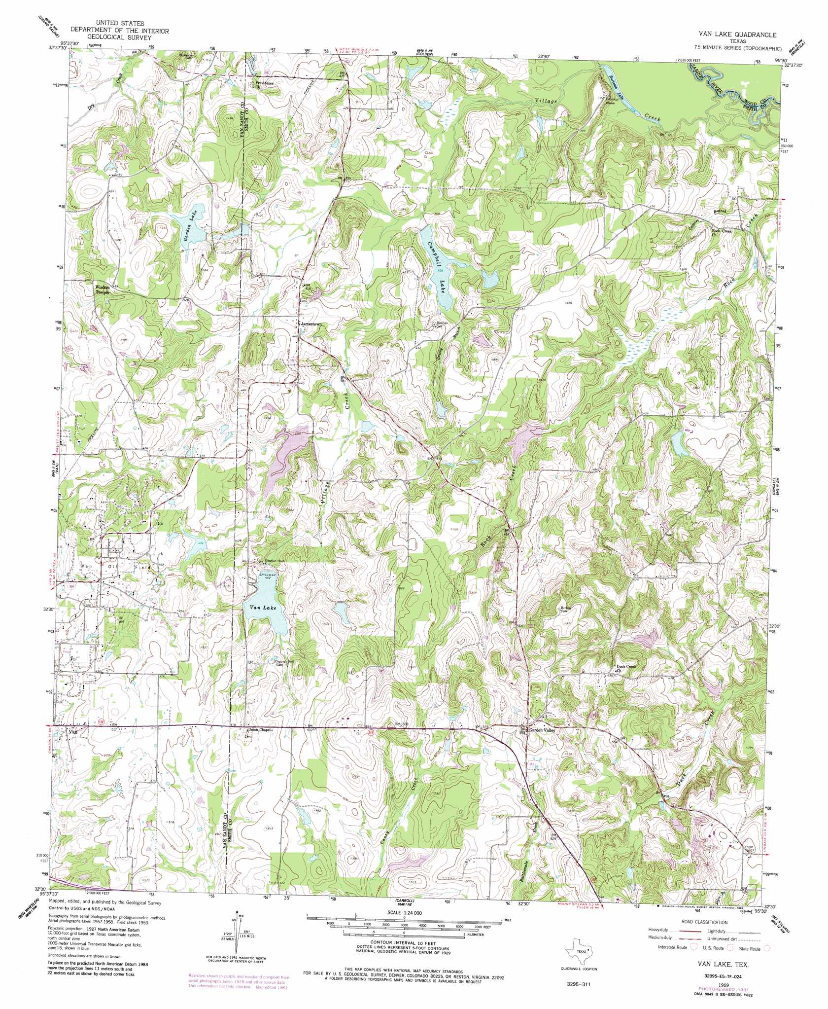
Van Lake Topo Map Texas
To zoom in, hover over the map of Van Lake
USGS Topo Quad 32095e5 - 1:24,000 scale
| Topo Map Name: | Van Lake |
| USGS Topo Quad ID: | 32095e5 |
| Print Size: | ca. 21 1/4" wide x 27" high |
| Southeast Coordinates: | 32.5° N latitude / 95.5° W longitude |
| Map Center Coordinates: | 32.5625° N latitude / 95.5625° W longitude |
| U.S. State: | TX |
| Filename: | o32095e5.jpg |
| Download Map JPG Image: | Van Lake topo map 1:24,000 scale |
| Map Type: | Topographic |
| Topo Series: | 7.5´ |
| Map Scale: | 1:24,000 |
| Source of Map Images: | United States Geological Survey (USGS) |
| Alternate Map Versions: |
Van Lake TX 1959, updated 1960 Download PDF Buy paper map Van Lake TX 1959, updated 1960 Download PDF Buy paper map Van Lake TX 1959, updated 1982 Download PDF Buy paper map Van Lake TX 1959, updated 1986 Download PDF Buy paper map Van Lake TX 2010 Download PDF Buy paper map Van Lake TX 2012 Download PDF Buy paper map Van Lake TX 2016 Download PDF Buy paper map |
1:24,000 Topo Quads surrounding Van Lake
Emory South |
Alba |
Calvary |
Quitman |
Cartwright |
Fruitvale |
Grand Saline |
Golden |
Mineola |
Hainesville |
Canton |
Van |
Van Lake |
Lindale |
Crow |
Martins Mill |
Ben Wheeler |
Carroll |
Mount Sylvan |
Tyler North |
Murchinson West |
Murchinson East |
Brownsboro |
Chandler |
Tyler South |
> Back to 32095e1 at 1:100,000 scale
> Back to 32094a1 at 1:250,000 scale
> Back to U.S. Topo Maps home
Van Lake topo map: Gazetteer
Van Lake: Dams
Campbell Dam elevation 107m 351′Garden Lake Dam elevation 124m 406′
Holiday Pines Dam elevation 102m 334′
Marsh Lake Dam elevation 141m 462′
Miller Lake Dam elevation 130m 426′
Mosley Lake Dam elevation 136m 446′
Reeves Lake Dam elevation 114m 374′
Reynolds Lake Dam elevation 141m 462′
Sandy Creek Dam elevation 124m 406′
Valley Club Lake Dam elevation 125m 410′
Van Lake Dam elevation 128m 419′
World Challenge Lake Number 1 Dam elevation 165m 541′
World Challenge Lake Number 2 Dam elevation 162m 531′
World Challenge Lake Number 3 Dam elevation 161m 528′
World Challenge Lake Number 4 Dam elevation 164m 538′
World Challenge Lake Number 5 Dam elevation 178m 583′
Van Lake: Lakes
Burleson Lake elevation 97m 318′Van Lake elevation 135m 442′
Van Lake: Populated Places
Garden Valley elevation 180m 590′Jamestown elevation 132m 433′
Van Lake: Reservoirs
Campbell Lake elevation 109m 357′Garden Lake elevation 127m 416′
Holiday Pines Lake elevation 102m 334′
Marsh Lake elevation 141m 462′
Miller Lake elevation 130m 426′
Mosley Lake elevation 136m 446′
Reeves Lake elevation 114m 374′
Reynolds Lake elevation 141m 462′
Sky Lake elevation 124m 406′
Valley Club Lake elevation 125m 410′
Van Lake elevation 128m 419′
World Challenge Lake Number 1 elevation 165m 541′
World Challenge Lake Number 2 elevation 162m 531′
World Challenge Lake Number 3 elevation 161m 528′
World Challenge Lake Number 4 elevation 164m 538′
World Challenge Lake Number 5 elevation 178m 583′
Van Lake: Streams
Bearfield Branch elevation 98m 321′Brushy Branch elevation 104m 341′
Coppers Branch elevation 103m 337′
Niblack Branch elevation 106m 347′
Village Creek elevation 95m 311′
Van Lake digital topo map on disk
Buy this Van Lake topo map showing relief, roads, GPS coordinates and other geographical features, as a high-resolution digital map file on DVD: