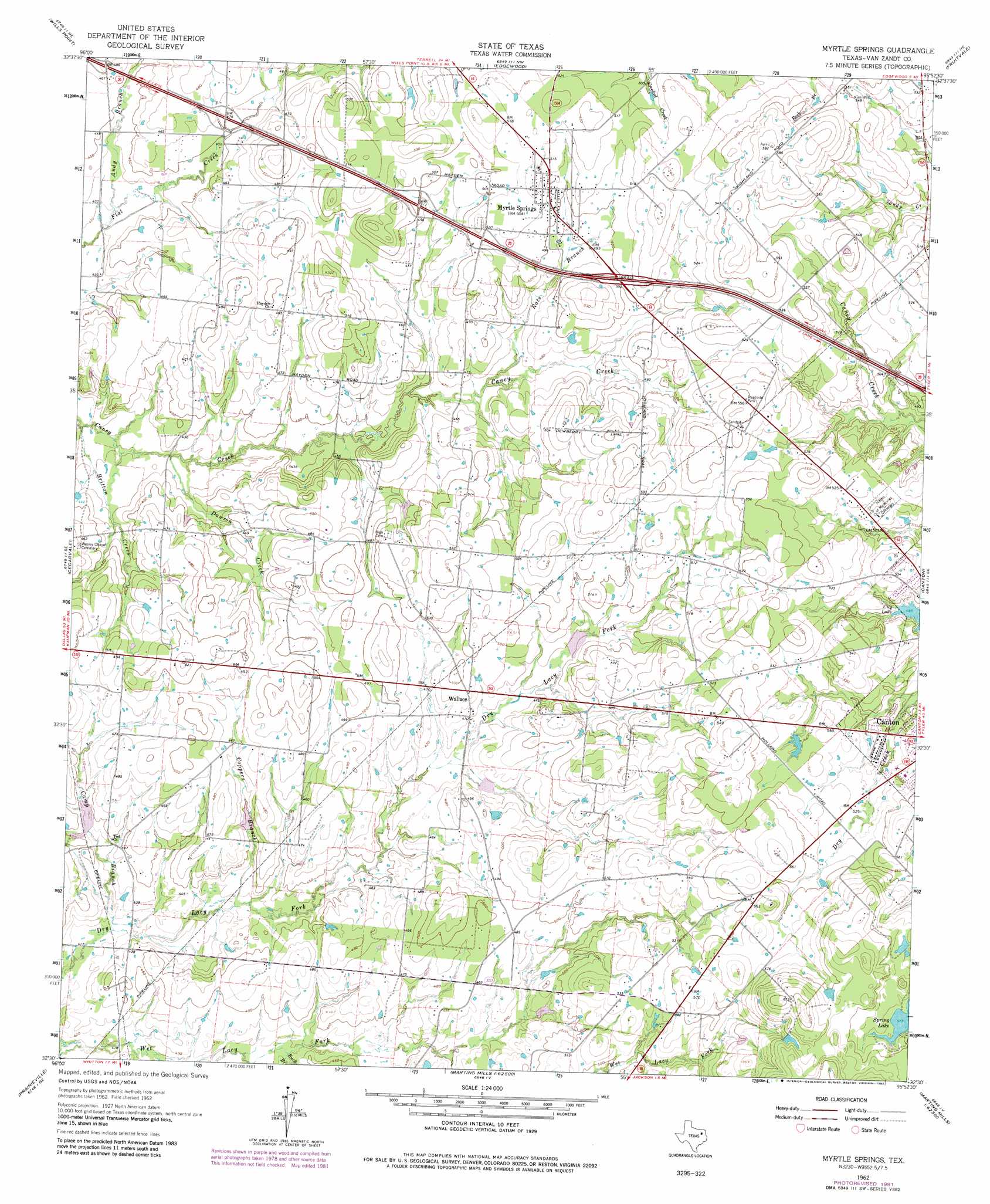
Myrtle Springs Topo Map Texas
To zoom in, hover over the map of Myrtle Springs
USGS Topo Quad 32095e8 - 1:24,000 scale
| Topo Map Name: | Myrtle Springs |
| USGS Topo Quad ID: | 32095e8 |
| Print Size: | ca. 21 1/4" wide x 27" high |
| Southeast Coordinates: | 32.5° N latitude / 95.875° W longitude |
| Map Center Coordinates: | 32.5625° N latitude / 95.9375° W longitude |
| U.S. State: | TX |
| Filename: | o32095e8.jpg |
| Download Map JPG Image: | Myrtle Springs topo map 1:24,000 scale |
| Map Type: | Topographic |
| Topo Series: | 7.5´ |
| Map Scale: | 1:24,000 |
| Source of Map Images: | United States Geological Survey (USGS) |
| Alternate Map Versions: |
Myrtle Springs TX 1962, updated 1965 Download PDF Buy paper map Myrtle Springs TX 1962, updated 1976 Download PDF Buy paper map Myrtle Springs TX 1962, updated 1982 Download PDF Buy paper map Myrtle Springs TX 2010 Download PDF Buy paper map Myrtle Springs TX 2012 Download PDF Buy paper map Myrtle Springs TX 2016 Download PDF Buy paper map |
1:24,000 Topo Quads surrounding Myrtle Springs
Poetry |
Ables Springs |
Iron Bridge Dam |
Emory South |
Alba |
Elmo |
Wills Point |
Edgewood |
Fruitvale |
Grand Saline |
Ola |
Cedarvale |
Myrtle Springs |
Canton |
Van |
Kemp |
Prairieville |
Phalba |
Martins Mill |
Ben Wheeler |
Tool |
Mabank |
Stockard |
Murchinson West |
Murchinson East |
> Back to 32095e1 at 1:100,000 scale
> Back to 32094a1 at 1:250,000 scale
> Back to U.S. Topo Maps home
Myrtle Springs topo map: Gazetteer
Myrtle Springs: Airports
Denniss Flying Farm Airport elevation 156m 511′Myrtle Springs: Dams
Cotton Lake Dam elevation 147m 482′Lipsey Lake Dam elevation 159m 521′
Soil Conservation Service Site 123 Dam elevation 146m 479′
Soil Conservation Service Site 124 Dam elevation 141m 462′
Soil Conservation Service Site 126 Dam elevation 138m 452′
Soil Conservation Service Site 127 Dam elevation 134m 439′
Myrtle Springs: Populated Places
Myrtle Springs elevation 153m 501′Wallace elevation 148m 485′
Myrtle Springs: Reservoirs
Cotton Lake elevation 147m 482′Lipsey Lake elevation 159m 521′
Soil Conservation Service Site 123 Reservoir elevation 146m 479′
Soil Conservation Service Site 124 Reservoir elevation 141m 462′
Soil Conservation Service Site 126 Reservoir elevation 138m 452′
Soil Conservation Service Site 127 Reservoir elevation 134m 439′
Myrtle Springs: Springs
Riley Spring elevation 197m 646′Myrtle Springs: Streams
Andy Branch elevation 131m 429′Britton Creek elevation 125m 410′
Buck Branch elevation 131m 429′
Camp Branch elevation 126m 413′
Coppers Branch elevation 131m 429′
Dawson Creek elevation 128m 419′
Rats Branch elevation 142m 465′
Myrtle Springs digital topo map on disk
Buy this Myrtle Springs topo map showing relief, roads, GPS coordinates and other geographical features, as a high-resolution digital map file on DVD: