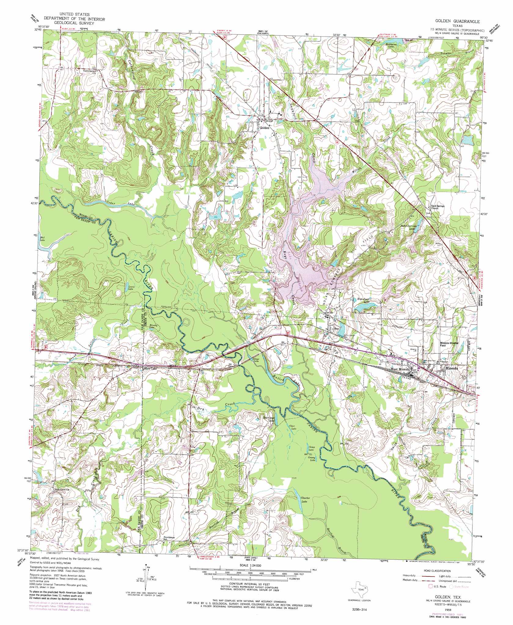
Golden Topo Map Texas
To zoom in, hover over the map of Golden
USGS Topo Quad 32095f5 - 1:24,000 scale
| Topo Map Name: | Golden |
| USGS Topo Quad ID: | 32095f5 |
| Print Size: | ca. 21 1/4" wide x 27" high |
| Southeast Coordinates: | 32.625° N latitude / 95.5° W longitude |
| Map Center Coordinates: | 32.6875° N latitude / 95.5625° W longitude |
| U.S. State: | TX |
| Filename: | o32095f5.jpg |
| Download Map JPG Image: | Golden topo map 1:24,000 scale |
| Map Type: | Topographic |
| Topo Series: | 7.5´ |
| Map Scale: | 1:24,000 |
| Source of Map Images: | United States Geological Survey (USGS) |
| Alternate Map Versions: |
Golden TX 1959, updated 1960 Download PDF Buy paper map Golden TX 1959, updated 1960 Download PDF Buy paper map Golden TX 1959, updated 1981 Download PDF Buy paper map Golden TX 2010 Download PDF Buy paper map Golden TX 2012 Download PDF Buy paper map Golden TX 2016 Download PDF Buy paper map |
1:24,000 Topo Quads surrounding Golden
Emory North |
Arbala |
Yantis |
Pleasant Grove |
Winnsboro |
Emory South |
Alba |
Calvary |
Quitman |
Cartwright |
Fruitvale |
Grand Saline |
Golden |
Mineola |
Hainesville |
Canton |
Van |
Van Lake |
Lindale |
Crow |
Martins Mill |
Ben Wheeler |
Carroll |
Mount Sylvan |
Tyler North |
> Back to 32095e1 at 1:100,000 scale
> Back to 32094a1 at 1:250,000 scale
> Back to U.S. Topo Maps home
Golden topo map: Gazetteer
Golden: Airports
Mineola Wisener Field elevation 127m 416′Golden: Dams
Big L Lake Dam elevation 125m 410′Kim Juan Lake Dam elevation 120m 393′
Plunk Lake Dam elevation 115m 377′
Wood County Dam Number 2 elevation 104m 341′
Golden: Lakes
Brushy Lake elevation 101m 331′Butler Lake elevation 97m 318′
Camp Lake elevation 98m 321′
Cedar Lake elevation 101m 331′
Charter Lake elevation 99m 324′
Clear Lake elevation 98m 321′
Grassy Lake elevation 98m 321′
Lewis Lake elevation 100m 328′
Schrivnor Lake elevation 99m 324′
Silver Lake elevation 97m 318′
Golden: Oilfields
Nolan-Edwards Oil Field elevation 136m 446′Golden: Populated Places
Ben elevation 117m 383′Golden elevation 130m 426′
Silver Lake elevation 119m 390′
West Mineola elevation 119m 390′
Golden: Reservoirs
Big L Lake elevation 125m 410′Kim Juan Lake elevation 120m 393′
Kim-Juan Lake elevation 115m 377′
Lake Holbrook elevation 104m 341′
Plunk Lake elevation 115m 377′
Sand Springs Lake elevation 138m 452′
Golden: Streams
Cottonwood Creek elevation 100m 328′Dry Creek elevation 96m 314′
Grand Saline Creek elevation 98m 321′
Keys Creek elevation 98m 321′
Lankford Creek elevation 115m 377′
Smith Creek elevation 112m 367′
Wellon Creek elevation 115m 377′
Golden digital topo map on disk
Buy this Golden topo map showing relief, roads, GPS coordinates and other geographical features, as a high-resolution digital map file on DVD: