Quitman Topo Map Texas
To zoom in, hover over the map of Quitman
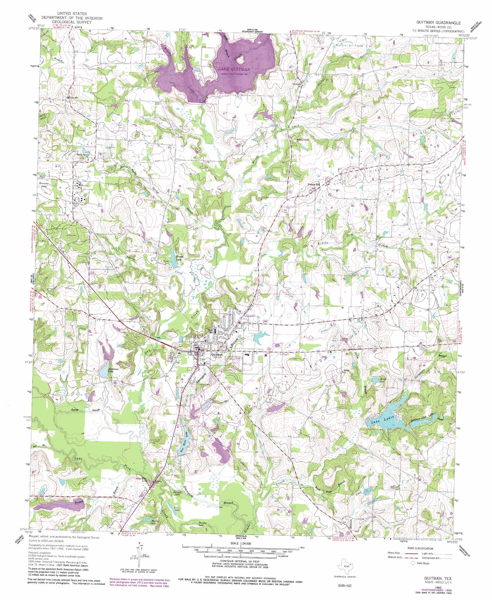
USGS Topo Quad 32095g4 - 1:24,000 scale
| Topo Map Name: | Quitman |
| USGS Topo Quad ID: | 32095g4 |
| Print Size: | ca. 21 1/4" wide x 27" high |
| Southeast Coordinates: | 32.75° N latitude / 95.375° W longitude |
| Map Center Coordinates: | 32.8125° N latitude / 95.4375° W longitude |
| U.S. State: | TX |
| Filename: | o32095g4.jpg |
| Download Map JPG Image: | Quitman topo map 1:24,000 scale |
| Map Type: | Topographic |
| Topo Series: | 7.5´ |
| Map Scale: | 1:24,000 |
| Source of Map Images: | United States Geological Survey (USGS) |
| Alternate Map Versions: |
Quitman TX 1960, updated 1962 Download PDF Buy paper map Quitman TX 1960, updated 1978 Download PDF Buy paper map Quitman TX 1960, updated 1980 Download PDF Buy paper map Quitman TX 2010 Download PDF Buy paper map Quitman TX 2012 Download PDF Buy paper map Quitman TX 2016 Download PDF Buy paper map |
1:24,000 Topo Quads surrounding Quitman
Brashear |
Sulphur Springs Se |
Como |
Purley |
New Hope |
Arbala |
Yantis |
Pleasant Grove |
Winnsboro |
Newsome |
Alba |
Calvary |
Quitman |
Cartwright |
Rhonesboro |
Grand Saline |
Golden |
Mineola |
Hainesville |
Shady Grove |
Van |
Van Lake |
Lindale |
Crow |
Hawkins |
> Back to 32095e1 at 1:100,000 scale
> Back to 32094a1 at 1:250,000 scale
> Back to U.S. Topo Maps home
Quitman topo map: Gazetteer
Quitman: Dams
Crystal Lake Dam elevation 112m 367′Forkview Lake Dam elevation 113m 370′
Greens Lake Dam elevation 113m 370′
Harris Lake B Dam elevation 122m 400′
Lake Lydia Dam elevation 113m 370′
Lake Timado Dam elevation 105m 344′
New Wells Dam Number 1 elevation 116m 380′
Quitman Club Lake Dam elevation 116m 380′
Wells Dam Number 4 elevation 103m 337′
Wells Dam Number 5 elevation 118m 387′
Wells Lake Number 2 Dam elevation 117m 383′
Wood County Dam Number 1 elevation 126m 413′
Quitman: Guts
George Slough elevation 101m 331′Quitman: Lakes
Aley Wine Lake elevation 99m 324′Brushy Lake elevation 101m 331′
Hannah Lake elevation 101m 331′
Wells Lake elevation 99m 324′
Quitman: Oilfields
Coats Oil Field elevation 145m 475′Merigale-Paul Oil Field elevation 131m 429′
Quitman Oil Field elevation 137m 449′
Quitman: Populated Places
Forest Hill elevation 141m 462′Quitman elevation 126m 413′
Quitman: Reservoirs
Andrews Lake elevation 113m 370′Crystal Lake elevation 112m 367′
Forkview Lake elevation 113m 370′
Greens Lake elevation 113m 370′
Harris Lake elevation 122m 400′
Herrin Lake elevation 107m 351′
Lake Lydia elevation 113m 370′
Lake Quitman elevation 126m 413′
Lake Timado elevation 105m 344′
New Wells Lake elevation 109m 357′
New Wells Lake Number 1 elevation 116m 380′
Quitman Club Lake elevation 116m 380′
Shield Lake elevation 117m 383′
Wells Lake Number 2 elevation 117m 383′
Wells Lake Number 4 elevation 103m 337′
Wells Lake Number 5 elevation 118m 387′
Quitman: Streams
Brushy Creek elevation 118m 387′Caney Creek elevation 103m 337′
Carter Creek elevation 114m 374′
Chinquapin Branch elevation 114m 374′
Dry Creek elevation 99m 324′
Duck Pond Branch elevation 102m 334′
Glade Branch elevation 120m 393′
Graveyard Branch elevation 99m 324′
Little Dry Creek elevation 107m 351′
Muddy Creek elevation 109m 357′
Myrtle Springs Branch elevation 107m 351′
Salt Branch elevation 100m 328′
Shiloh Branch elevation 109m 357′
Turman Branch elevation 99m 324′
Quitman digital topo map on disk
Buy this Quitman topo map showing relief, roads, GPS coordinates and other geographical features, as a high-resolution digital map file on DVD: