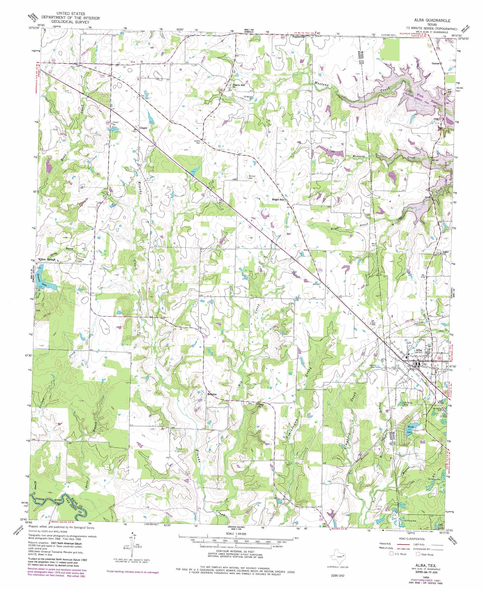
Alba Topo Map Texas
To zoom in, hover over the map of Alba
USGS Topo Quad 32095g6 - 1:24,000 scale
| Topo Map Name: | Alba |
| USGS Topo Quad ID: | 32095g6 |
| Print Size: | ca. 21 1/4" wide x 27" high |
| Southeast Coordinates: | 32.75° N latitude / 95.625° W longitude |
| Map Center Coordinates: | 32.8125° N latitude / 95.6875° W longitude |
| U.S. State: | TX |
| Filename: | o32095g6.jpg |
| Download Map JPG Image: | Alba topo map 1:24,000 scale |
| Map Type: | Topographic |
| Topo Series: | 7.5´ |
| Map Scale: | 1:24,000 |
| Source of Map Images: | United States Geological Survey (USGS) |
| Alternate Map Versions: |
Alba TX 1958, updated 1960 Download PDF Buy paper map Alba TX 1958, updated 1982 Download PDF Buy paper map Alba TX 1958, updated 1987 Download PDF Buy paper map Alba TX 2011 Download PDF Buy paper map Alba TX 2012 Download PDF Buy paper map Alba TX 2016 Download PDF Buy paper map |
1:24,000 Topo Quads surrounding Alba
Lone Oak North |
Miller Grove |
Brashear |
Sulphur Springs Se |
Como |
Lone Oak South |
Emory North |
Arbala |
Yantis |
Pleasant Grove |
Iron Bridge Dam |
Emory South |
Alba |
Calvary |
Quitman |
Edgewood |
Fruitvale |
Grand Saline |
Golden |
Mineola |
Myrtle Springs |
Canton |
Van |
Van Lake |
Lindale |
> Back to 32095e1 at 1:100,000 scale
> Back to 32094a1 at 1:250,000 scale
> Back to U.S. Topo Maps home
Alba topo map: Gazetteer
Alba: Dams
Greenes Lake Dam elevation 120m 393′Woods Lake Dam elevation 128m 419′
Alba: Parks
Jenkins Park elevation 144m 472′Alba: Populated Places
Alba elevation 137m 449′Bellview elevation 127m 416′
Bright Star elevation 144m 472′
Colony elevation 115m 377′
Ginger elevation 144m 472′
Gunter elevation 126m 413′
Alba: Reservoirs
Greenes Lake elevation 125m 410′Woods Lake elevation 122m 400′
Alba: Streams
Big Creek elevation 105m 344′Hill Branch elevation 112m 367′
Wilson Branch elevation 123m 403′
Alba digital topo map on disk
Buy this Alba topo map showing relief, roads, GPS coordinates and other geographical features, as a high-resolution digital map file on DVD: