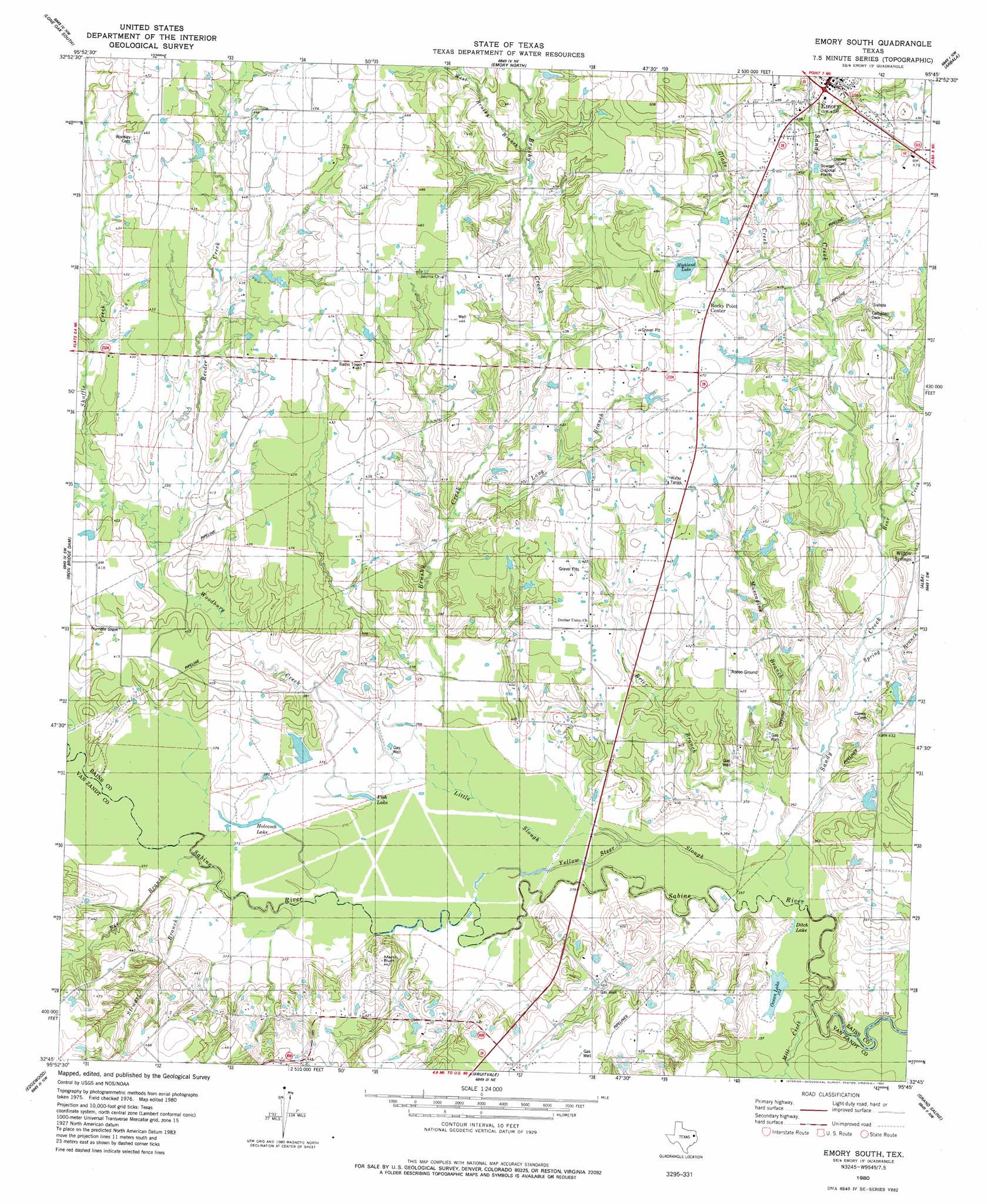
Emory South Topo Map Texas
To zoom in, hover over the map of Emory South
USGS Topo Quad 32095g7 - 1:24,000 scale
| Topo Map Name: | Emory South |
| USGS Topo Quad ID: | 32095g7 |
| Print Size: | ca. 21 1/4" wide x 27" high |
| Southeast Coordinates: | 32.75° N latitude / 95.75° W longitude |
| Map Center Coordinates: | 32.8125° N latitude / 95.8125° W longitude |
| U.S. State: | TX |
| Filename: | o32095g7.jpg |
| Download Map JPG Image: | Emory South topo map 1:24,000 scale |
| Map Type: | Topographic |
| Topo Series: | 7.5´ |
| Map Scale: | 1:24,000 |
| Source of Map Images: | United States Geological Survey (USGS) |
| Alternate Map Versions: |
Emory South TX 1980, updated 1980 Download PDF Buy paper map Emory South TX 2010 Download PDF Buy paper map Emory South TX 2012 Download PDF Buy paper map Emory South TX 2016 Download PDF Buy paper map |
1:24,000 Topo Quads surrounding Emory South
Greenville Se |
Lone Oak North |
Miller Grove |
Brashear |
Sulphur Springs Se |
West Tawakoni |
Lone Oak South |
Emory North |
Arbala |
Yantis |
Ables Springs |
Iron Bridge Dam |
Emory South |
Alba |
Calvary |
Wills Point |
Edgewood |
Fruitvale |
Grand Saline |
Golden |
Cedarvale |
Myrtle Springs |
Canton |
Van |
Van Lake |
> Back to 32095e1 at 1:100,000 scale
> Back to 32094a1 at 1:250,000 scale
> Back to U.S. Topo Maps home
Emory South topo map: Gazetteer
Emory South: Airports
Parkland Memorial Hospital Heliport elevation 127m 416′Emory South: Cliffs
Martin Bluff elevation 132m 433′Emory South: Guts
Holcomb Slough elevation 115m 377′Yellow Steer Slough elevation 110m 360′
Emory South: Lakes
Ditch Lake elevation 109m 357′Fish Lake elevation 113m 370′
Highland Lake elevation 142m 465′
Holcomb Lake elevation 115m 377′
Lake Church elevation 128m 419′
Ocean Lake elevation 107m 351′
Emory South: Populated Places
Dunbar elevation 132m 433′Emory elevation 146m 479′
Rocky Point Center elevation 146m 479′
Smyrna elevation 143m 469′
Willow Springs elevation 122m 400′
Emory South: Streams
Allread Creek elevation 108m 354′Bear Creek elevation 116m 380′
Bee Branch elevation 113m 370′
Brushy Creek elevation 111m 364′
Glade Creek elevation 123m 403′
Little Slough elevation 110m 360′
Long Branch elevation 118m 387′
Mill Creek elevation 107m 351′
Muscadine Branch elevation 110m 360′
Reeder Creek elevation 118m 387′
Sandy Creek elevation 107m 351′
Shuffle Creek elevation 118m 387′
Spring Branch elevation 112m 367′
Stewart Branch elevation 113m 370′
West Brushy Branch elevation 128m 419′
Woodbury Creek elevation 113m 370′
Emory South digital topo map on disk
Buy this Emory South topo map showing relief, roads, GPS coordinates and other geographical features, as a high-resolution digital map file on DVD: