Leesburg Topo Map Texas
To zoom in, hover over the map of Leesburg
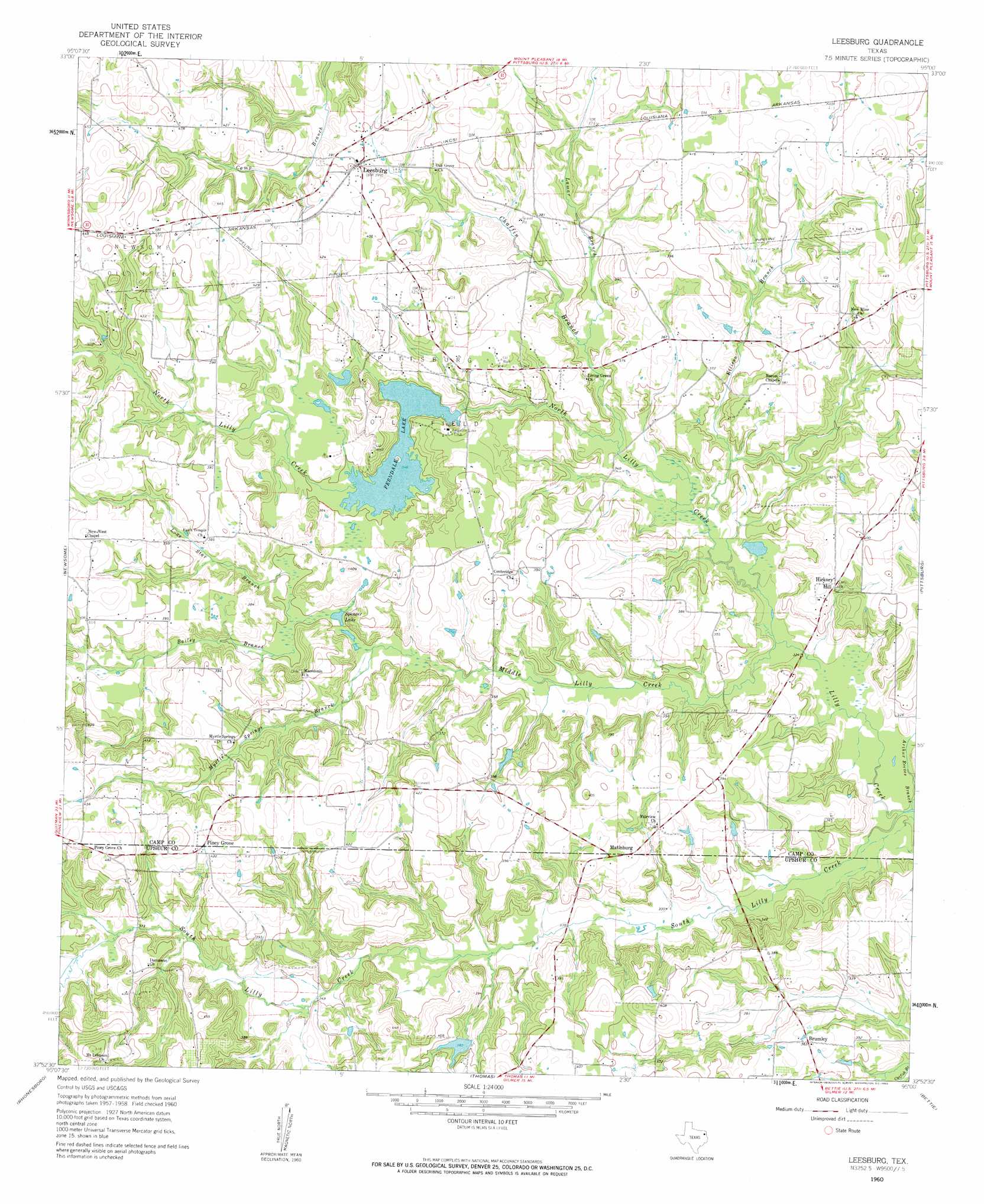
USGS Topo Quad 32095h1 - 1:24,000 scale
| Topo Map Name: | Leesburg |
| USGS Topo Quad ID: | 32095h1 |
| Print Size: | ca. 21 1/4" wide x 27" high |
| Southeast Coordinates: | 32.875° N latitude / 95° W longitude |
| Map Center Coordinates: | 32.9375° N latitude / 95.0625° W longitude |
| U.S. State: | TX |
| Filename: | o32095h1.jpg |
| Download Map JPG Image: | Leesburg topo map 1:24,000 scale |
| Map Type: | Topographic |
| Topo Series: | 7.5´ |
| Map Scale: | 1:24,000 |
| Source of Map Images: | United States Geological Survey (USGS) |
| Alternate Map Versions: |
Leesburg TX 1960, updated 1962 Download PDF Buy paper map Leesburg TX 1960, updated 1962 Download PDF Buy paper map Leesburg TX 2010 Download PDF Buy paper map Leesburg TX 2012 Download PDF Buy paper map Leesburg TX 2016 Download PDF Buy paper map |
1:24,000 Topo Quads surrounding Leesburg
Saltillo |
Mount Vernon |
Winfield |
Mount Pleasant |
Cookville |
Purley |
New Hope |
Monticello |
Harvard |
Cason |
Winnsboro |
Newsome |
Leesburg |
Pittsburg |
Lafayette |
Cartwright |
Rhonesboro |
Thomas |
Bettie |
Coffeeville |
Hainesville |
Shady Grove |
Pritchett |
Gilmer |
Glenwood |
> Back to 32095e1 at 1:100,000 scale
> Back to 32094a1 at 1:250,000 scale
> Back to U.S. Topo Maps home
Leesburg topo map: Gazetteer
Leesburg: Dams
Ferndale Dam elevation 106m 347′Harris Lake Dam elevation 117m 383′
Leesburg: Lakes
Spencer Lake elevation 105m 344′Leesburg: Oilfields
Newsome Oil Field elevation 136m 446′Pittsburg Oil Field elevation 118m 387′
Leesburg: Populated Places
Brumley elevation 112m 367′Hickory Hill elevation 114m 374′
Leesburg elevation 121m 396′
Matinburg elevation 118m 387′
Piney Grove elevation 132m 433′
Leesburg: Reservoirs
Ferndale Lake elevation 106m 347′Harris Lake elevation 117m 383′
Leesburg: Streams
Arthur Reeves Branch elevation 94m 308′Bailey Branch elevation 106m 347′
Chaffin Branch elevation 100m 328′
Ellison Branch elevation 100m 328′
Lamar Branch elevation 102m 334′
Lone Star Branch elevation 106m 347′
Middle Lilly Creek elevation 97m 318′
Myrtle Springs Branch elevation 102m 334′
North Lilly Creek elevation 97m 318′
South Lilly Creek elevation 94m 308′
Leesburg digital topo map on disk
Buy this Leesburg topo map showing relief, roads, GPS coordinates and other geographical features, as a high-resolution digital map file on DVD: