Blooming Grove Topo Map Texas
To zoom in, hover over the map of Blooming Grove
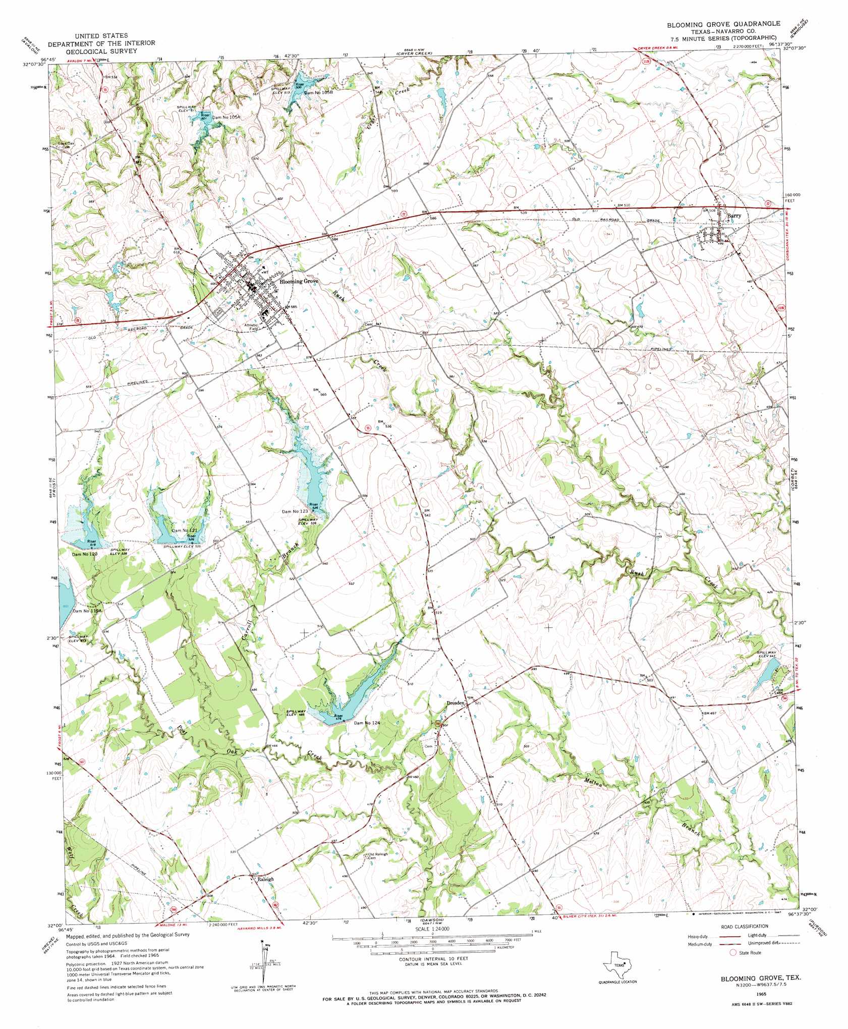
USGS Topo Quad 32096a6 - 1:24,000 scale
| Topo Map Name: | Blooming Grove |
| USGS Topo Quad ID: | 32096a6 |
| Print Size: | ca. 21 1/4" wide x 27" high |
| Southeast Coordinates: | 32° N latitude / 96.625° W longitude |
| Map Center Coordinates: | 32.0625° N latitude / 96.6875° W longitude |
| U.S. State: | TX |
| Filename: | o32096a6.jpg |
| Download Map JPG Image: | Blooming Grove topo map 1:24,000 scale |
| Map Type: | Topographic |
| Topo Series: | 7.5´ |
| Map Scale: | 1:24,000 |
| Source of Map Images: | United States Geological Survey (USGS) |
| Alternate Map Versions: |
Blooming Grove TX 1965, updated 1967 Download PDF Buy paper map Blooming Grove TX 2010 Download PDF Buy paper map Blooming Grove TX 2012 Download PDF Buy paper map Blooming Grove TX 2016 Download PDF Buy paper map |
1:24,000 Topo Quads surrounding Blooming Grove
Boz |
Forreston |
Ennis West |
Ennis East |
Rosser Sw |
Italy |
Avalon |
Cryer Creek |
Emhouse |
Chatfield |
Mertens |
Frost |
Blooming Grove |
Corbet |
Corsicana |
Malone |
Irene |
Dawson |
Purdon |
Richland |
Penelope |
Hubbard |
Coolidge |
Union High |
Wortham |
> Back to 32096a1 at 1:100,000 scale
> Back to 32096a1 at 1:250,000 scale
> Back to U.S. Topo Maps home
Blooming Grove topo map: Gazetteer
Blooming Grove: Dams
Cox Lake Dam elevation 133m 436′Dam Number 105A elevation 154m 505′
Dam Number 105B elevation 152m 498′
Dam Number 120 elevation 160m 524′
Dam Number 121 elevation 160m 524′
Dam Number 123 elevation 160m 524′
Dam Number 124 elevation 146m 479′
Soil Conservation Service Site 105a Dam elevation 160m 524′
Soil Conservation Service Site 105b Dam elevation 154m 505′
Soil Conservation Service Site 120 Dam elevation 158m 518′
Soil Conservation Service Site 121 Dam elevation 160m 524′
Soil Conservation Service Site 123 Dam elevation 160m 524′
Soil Conservation Service Site 124 Dam elevation 143m 469′
Soil Conservation Service Site 134 Dam elevation 142m 465′
Soil Conservation Service Site 135a Dam elevation 140m 459′
Soil Conservation Service Site 135b Dam elevation 135m 442′
Blooming Grove: Populated Places
Barry elevation 152m 498′Blooming Grove elevation 182m 597′
Dresden elevation 159m 521′
Raleigh elevation 149m 488′
Blooming Grove: Reservoirs
Cox Lake elevation 133m 436′Soil Conservation Service Site 105a Reservoir elevation 160m 524′
Soil Conservation Service Site 105b Reservoir elevation 154m 505′
Soil Conservation Service Site 120 Reservoir elevation 158m 518′
Soil Conservation Service Site 121 Reservoir elevation 160m 524′
Soil Conservation Service Site 123 Reservoir elevation 160m 524′
Soil Conservation Service Site 124 Reservoir elevation 143m 469′
Soil Conservation Service Site 134 Reservoir elevation 142m 465′
Soil Conservation Service Site 135a Reservoir elevation 140m 459′
Soil Conservation Service Site 135b Reservoir elevation 135m 442′
Blooming Grove: Streams
Carroll Branch elevation 140m 459′Blooming Grove digital topo map on disk
Buy this Blooming Grove topo map showing relief, roads, GPS coordinates and other geographical features, as a high-resolution digital map file on DVD: