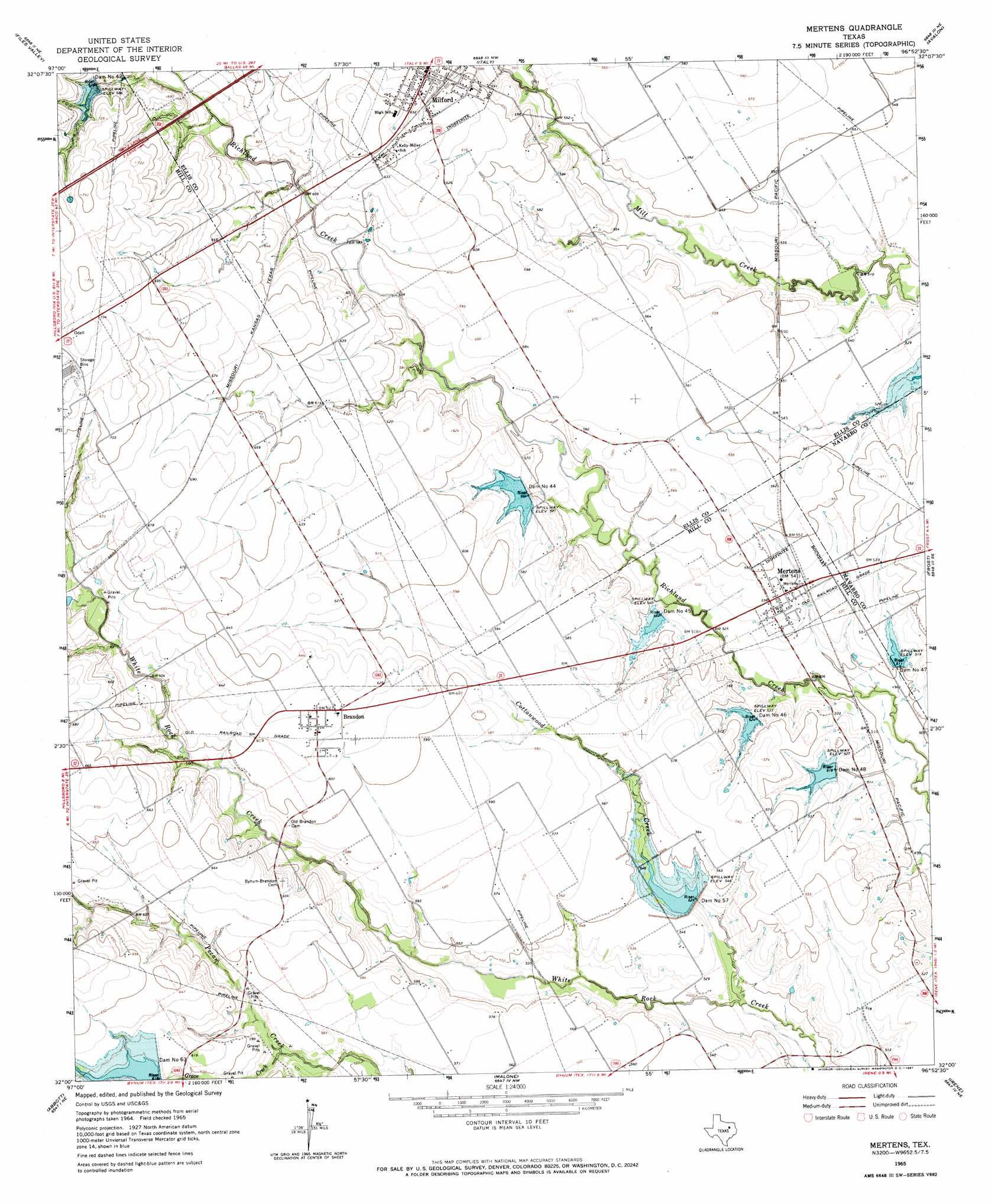
Mertens Topo Map Texas
To zoom in, hover over the map of Mertens
USGS Topo Quad 32096a8 - 1:24,000 scale
| Topo Map Name: | Mertens |
| USGS Topo Quad ID: | 32096a8 |
| Print Size: | ca. 21 1/4" wide x 27" high |
| Southeast Coordinates: | 32° N latitude / 96.875° W longitude |
| Map Center Coordinates: | 32.0625° N latitude / 96.9375° W longitude |
| U.S. State: | TX |
| Filename: | o32096a8.jpg |
| Download Map JPG Image: | Mertens topo map 1:24,000 scale |
| Map Type: | Topographic |
| Topo Series: | 7.5´ |
| Map Scale: | 1:24,000 |
| Source of Map Images: | United States Geological Survey (USGS) |
| Alternate Map Versions: |
Mertens TX 1965, updated 1967 Download PDF Buy paper map Mertens TX 2010 Download PDF Buy paper map Mertens TX 2012 Download PDF Buy paper map Mertens TX 2016 Download PDF Buy paper map |
1:24,000 Topo Quads surrounding Mertens
Grandview |
Maypearl |
Boz |
Forreston |
Ennis West |
Itasca |
Files Valley |
Italy |
Avalon |
Cryer Creek |
Hillsboro West |
Hillsboro East |
Mertens |
Frost |
Blooming Grove |
Peoria |
Abbott |
Malone |
Irene |
Dawson |
Aquilla |
West |
Penelope |
Hubbard |
Coolidge |
> Back to 32096a1 at 1:100,000 scale
> Back to 32096a1 at 1:250,000 scale
> Back to U.S. Topo Maps home
Mertens topo map: Gazetteer
Mertens: Dams
Dam Number 42 elevation 205m 672′Dam Number 44 elevation 166m 544′
Dam Number 45 elevation 161m 528′
Dam Number 46 elevation 161m 528′
Dam Number 47 elevation 156m 511′
Dam Number 48 elevation 158m 518′
Dam Number 57 elevation 166m 544′
Dam Number 63 elevation 188m 616′
Soil Conservation Service Site 42 Dam elevation 206m 675′
Soil Conservation Service Site 44 Dam elevation 166m 544′
Soil Conservation Service Site 45 Dam elevation 161m 528′
Soil Conservation Service Site 46 Dam elevation 160m 524′
Soil Conservation Service Site 47 Dam elevation 156m 511′
Soil Conservation Service Site 48 Dam elevation 158m 518′
Soil Conservation Service Site 57 Dam elevation 166m 544′
Soil Conservation Service Site 63 Dam elevation 188m 616′
Mertens: Populated Places
Brandon elevation 191m 626′Mertens elevation 164m 538′
Milford elevation 188m 616′
Mertens: Reservoirs
Soil Conservation Service Site 42 Reservoir elevation 206m 675′Soil Conservation Service Site 44 Reservoir elevation 166m 544′
Soil Conservation Service Site 45 Reservoir elevation 161m 528′
Soil Conservation Service Site 46 Reservoir elevation 160m 524′
Soil Conservation Service Site 47 Reservoir elevation 156m 511′
Soil Conservation Service Site 48 Reservoir elevation 158m 518′
Soil Conservation Service Site 57 Reservoir elevation 166m 544′
Soil Conservation Service Site 63 Reservoir elevation 188m 616′
Mertens: Streams
Cottonwood Creek elevation 149m 488′Grove Creek elevation 167m 547′
Mertens digital topo map on disk
Buy this Mertens topo map showing relief, roads, GPS coordinates and other geographical features, as a high-resolution digital map file on DVD: