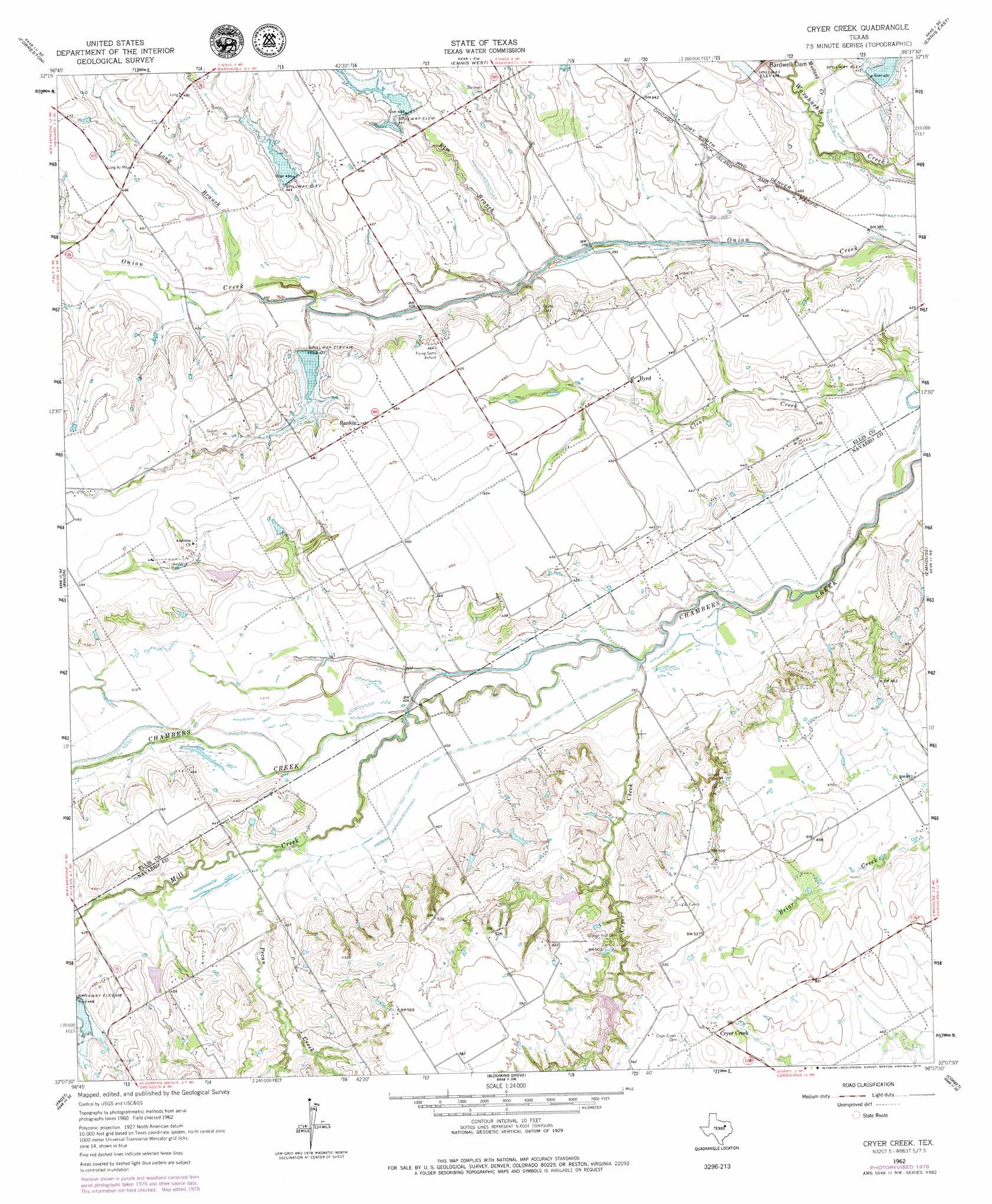
Cryer Creek Topo Map Texas
To zoom in, hover over the map of Cryer Creek
USGS Topo Quad 32096b6 - 1:24,000 scale
| Topo Map Name: | Cryer Creek |
| USGS Topo Quad ID: | 32096b6 |
| Print Size: | ca. 21 1/4" wide x 27" high |
| Southeast Coordinates: | 32.125° N latitude / 96.625° W longitude |
| Map Center Coordinates: | 32.1875° N latitude / 96.6875° W longitude |
| U.S. State: | TX |
| Filename: | o32096b6.jpg |
| Download Map JPG Image: | Cryer Creek topo map 1:24,000 scale |
| Map Type: | Topographic |
| Topo Series: | 7.5´ |
| Map Scale: | 1:24,000 |
| Source of Map Images: | United States Geological Survey (USGS) |
| Alternate Map Versions: |
Cryer Creek TX 1962, updated 1965 Download PDF Buy paper map Cryer Creek TX 1962, updated 1979 Download PDF Buy paper map Cryer Creek TX 2010 Download PDF Buy paper map Cryer Creek TX 2012 Download PDF Buy paper map Cryer Creek TX 2016 Download PDF Buy paper map |
1:24,000 Topo Quads surrounding Cryer Creek
Midlothian |
Waxahachie |
Palmer |
Bristol |
Rosser |
Boz |
Forreston |
Ennis West |
Ennis East |
Rosser Sw |
Italy |
Avalon |
Cryer Creek |
Emhouse |
Chatfield |
Mertens |
Frost |
Blooming Grove |
Corbet |
Corsicana |
Malone |
Irene |
Dawson |
Purdon |
Richland |
> Back to 32096a1 at 1:100,000 scale
> Back to 32096a1 at 1:250,000 scale
> Back to U.S. Topo Maps home
Cryer Creek topo map: Gazetteer
Cryer Creek: Dams
Soil Conservation Service Site 104a Dam elevation 140m 459′Soil Conservation Service Site 115 Dam elevation 134m 439′
Soil Conservation Service Site 116 Dam elevation 130m 426′
Soil Conservation Service Site 117 Dam elevation 133m 436′
Soil Conservation Service Site 119a Dam elevation 143m 469′
Soil Conservation Service Site 119b Dam elevation 146m 479′
Soil Conservation Service Site 29 Dam elevation 122m 400′
Soil Conservation Service Site 95 Dam elevation 135m 442′
Cryer Creek: Populated Places
Byrd elevation 135m 442′Cryer Creek elevation 158m 518′
Rankin elevation 144m 472′
Cryer Creek: Reservoirs
Soil Conservation Service Site 104a Reservoir elevation 140m 459′Soil Conservation Service Site 115 Reservoir elevation 134m 439′
Soil Conservation Service Site 116 Reservoir elevation 130m 426′
Soil Conservation Service Site 117 Reservoir elevation 133m 436′
Soil Conservation Service Site 119a Reservoir elevation 143m 469′
Soil Conservation Service Site 119b Reservoir elevation 146m 479′
Soil Conservation Service Site 29 Reservoir elevation 122m 400′
Soil Conservation Service Site 95 Reservoir elevation 135m 442′
Cryer Creek: Streams
Cryer Creek elevation 119m 390′Elm Branch elevation 118m 387′
Long Branch elevation 125m 410′
Mill Creek elevation 122m 400′
Mustang Creek elevation 116m 380′
Pecan Creek elevation 124m 406′
Cryer Creek: Trails
Tonkawa Trail elevation 120m 393′Cryer Creek digital topo map on disk
Buy this Cryer Creek topo map showing relief, roads, GPS coordinates and other geographical features, as a high-resolution digital map file on DVD: