Ennis West Topo Map Texas
To zoom in, hover over the map of Ennis West
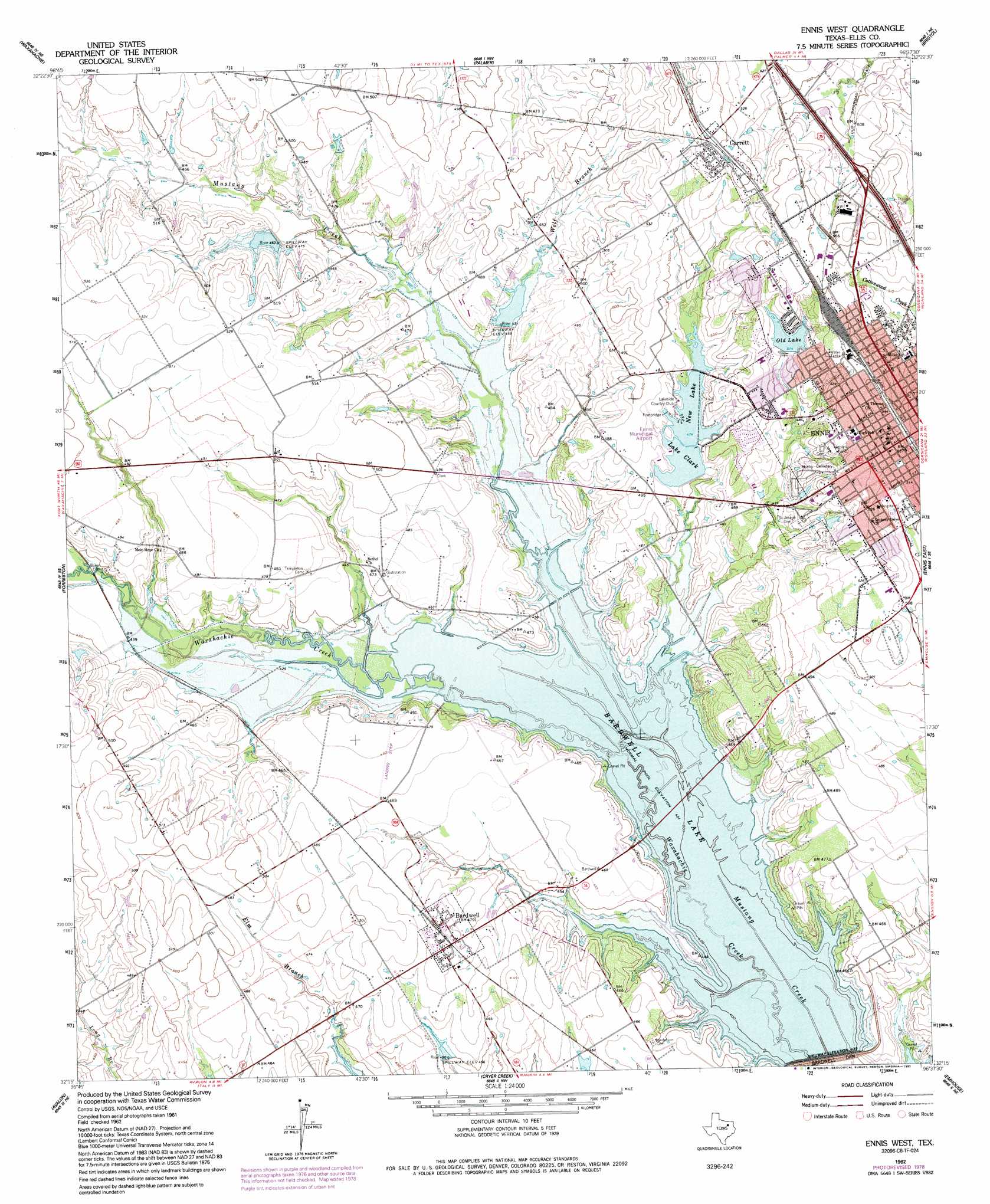
USGS Topo Quad 32096c6 - 1:24,000 scale
| Topo Map Name: | Ennis West |
| USGS Topo Quad ID: | 32096c6 |
| Print Size: | ca. 21 1/4" wide x 27" high |
| Southeast Coordinates: | 32.25° N latitude / 96.625° W longitude |
| Map Center Coordinates: | 32.3125° N latitude / 96.6875° W longitude |
| U.S. State: | TX |
| Filename: | o32096c6.jpg |
| Download Map JPG Image: | Ennis West topo map 1:24,000 scale |
| Map Type: | Topographic |
| Topo Series: | 7.5´ |
| Map Scale: | 1:24,000 |
| Source of Map Images: | United States Geological Survey (USGS) |
| Alternate Map Versions: |
Ennis West TX 1962, updated 1965 Download PDF Buy paper map Ennis West TX 1962, updated 1978 Download PDF Buy paper map Ennis West TX 1962, updated 1993 Download PDF Buy paper map Ennis West TX 2010 Download PDF Buy paper map Ennis West TX 2012 Download PDF Buy paper map Ennis West TX 2016 Download PDF Buy paper map |
1:24,000 Topo Quads surrounding Ennis West
Cedar Hill |
Lancaster |
Ferris |
India |
Scurry |
Midlothian |
Waxahachie |
Palmer |
Bristol |
Rosser |
Boz |
Forreston |
Ennis West |
Ennis East |
Rosser Sw |
Italy |
Avalon |
Cryer Creek |
Emhouse |
Chatfield |
Mertens |
Frost |
Blooming Grove |
Corbet |
Corsicana |
> Back to 32096a1 at 1:100,000 scale
> Back to 32096a1 at 1:250,000 scale
> Back to U.S. Topo Maps home
Ennis West topo map: Gazetteer
Ennis West: Airports
Ennis Municipal Airport elevation 146m 479′Flying O Airport elevation 146m 479′
Ennis West: Bays
New Lake elevation 144m 472′Ennis West: Dams
Bardwell Dam elevation 129m 423′Lake Clark Dam elevation 145m 475′
Old City Lake Dam elevation 154m 505′
Soil Conservation Service Site 118 Dam elevation 136m 446′
Soil Conservation Service Site 19 Dam elevation 141m 462′
Soil Conservation Service Site 20 Dam elevation 135m 442′
Ennis West: Parks
Big Mustang Creek Park elevation 141m 462′Bluebonnet City Park elevation 131m 429′
High View Park elevation 136m 446′
Jaycee Park elevation 160m 524′
Kachine Prairie Park elevation 154m 505′
Kiwanis Park elevation 157m 515′
Lake Clark Park elevation 140m 459′
Lions Stadium elevation 157m 515′
Little Mustang Creek Park elevation 134m 439′
Lower Love Park elevation 134m 439′
Mott Park elevation 134m 439′
Pierce Park elevation 165m 541′
Waxahachie Creek Park elevation 143m 469′
Ennis West: Populated Places
Bardwell elevation 147m 482′Ennis elevation 164m 538′
Garrett elevation 169m 554′
Ennis West: Reservoirs
Bardwell Lake elevation 128m 419′Lake Clark elevation 145m 475′
Old City Lake elevation 154m 505′
Old Lake elevation 157m 515′
Range Reservoir elevation 141m 462′
Soil Conservation Service Site 118 Reservoir elevation 136m 446′
Soil Conservation Service Site 19 Reservoir elevation 141m 462′
Soil Conservation Service Site 20 Reservoir elevation 135m 442′
Ennis West: Streams
Wolf Branch elevation 131m 429′Ennis West: Trails
Waxahachie Trail elevation 142m 465′Ennis West digital topo map on disk
Buy this Ennis West topo map showing relief, roads, GPS coordinates and other geographical features, as a high-resolution digital map file on DVD: