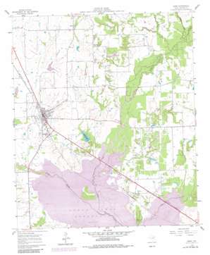
Kemp Topo Map Texas
To zoom in, hover over the map of Kemp
USGS Topo Quad 32096d2 - 1:24,000 scale
| Topo Map Name: | Kemp |
| USGS Topo Quad ID: | 32096d2 |
| Print Size: | ca. 21 1/4" wide x 27" high |
| Southeast Coordinates: | 32.375° N latitude / 96.125° W longitude |
| Map Center Coordinates: | 32.4375° N latitude / 96.1875° W longitude |
| U.S. State: | TX |
| Filename: | o32096d2.jpg |
| Download Map JPG Image: | Kemp topo map 1:24,000 scale |
| Map Type: | Topographic |
| Topo Series: | 7.5´ |
| Map Scale: | 1:24,000 |
| Source of Map Images: | United States Geological Survey (USGS) |
| Alternate Map Versions: |
Kemp TX 1961, updated 1962 Download PDF Buy paper map Kemp TX 1961, updated 1973 Download PDF Buy paper map Kemp TX 1961, updated 1982 Download PDF Buy paper map Kemp TX 1961, updated 1982 Download PDF Buy paper map Kemp TX 2011 Download PDF Buy paper map Kemp TX 2012 Download PDF Buy paper map Kemp TX 2016 Download PDF Buy paper map |
1:24,000 Topo Quads surrounding Kemp
> Back to 32096a1 at 1:100,000 scale
> Back to 32096a1 at 1:250,000 scale
> Back to U.S. Topo Maps home
Kemp topo map: Gazetteer
Kemp: Dams
Kemp Dam elevation 105m 344′Nolan Lake Dam elevation 105m 344′
Soil Conservation Service Site 85 Dam elevation 116m 380′
Kemp: Oilfields
Ham-Gossett Oil Field elevation 109m 357′Kemp: Parks
Cedar Creek Wildlife Management Area - Big Island Unit elevation 100m 328′Yellow Jacket Stadium elevation 113m 370′
Kemp: Populated Places
Becker elevation 125m 410′Kemp elevation 116m 380′
Kemp: Reservoirs
Kemp Lake elevation 110m 360′Nolan Lake elevation 105m 344′
Soil Conservation Service Site 85 Reservoir elevation 116m 380′
Kemp: Streams
Jones Creek elevation 105m 344′Kings Creek elevation 98m 321′
Walnut Creek elevation 104m 341′
Williams Creek elevation 106m 347′
Kemp digital topo map on disk
Buy this Kemp topo map showing relief, roads, GPS coordinates and other geographical features, as a high-resolution digital map file on DVD:


