Grays Prairie Topo Map Texas
To zoom in, hover over the map of Grays Prairie
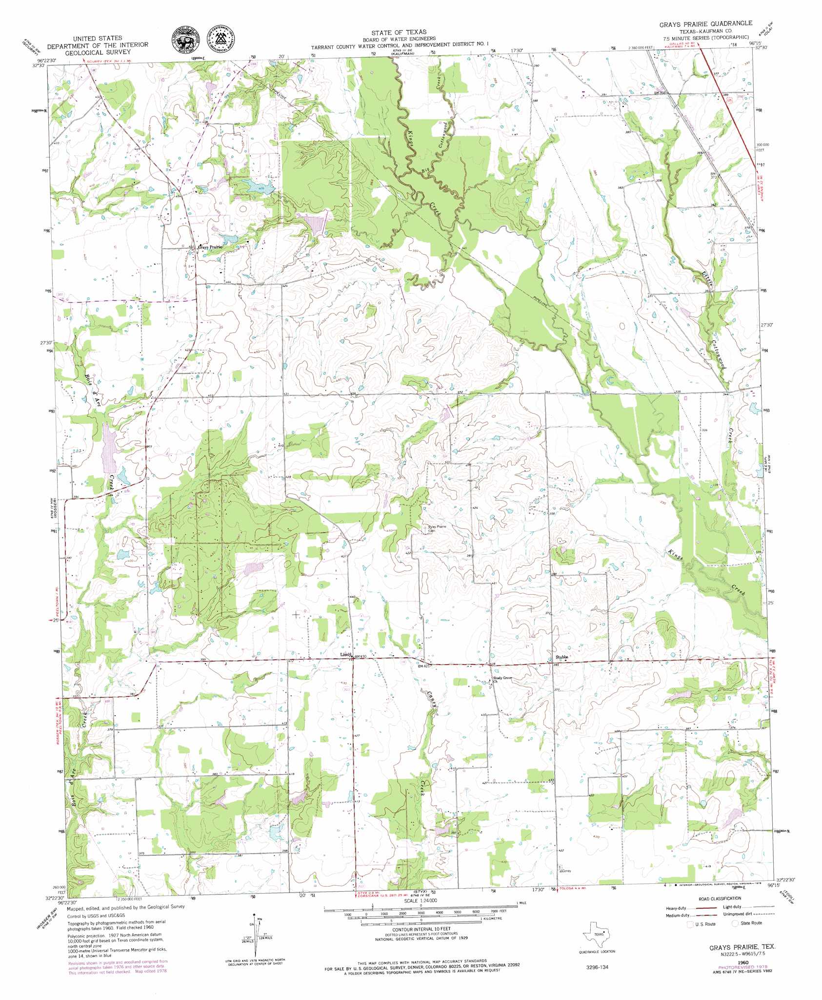
USGS Topo Quad 32096d3 - 1:24,000 scale
| Topo Map Name: | Grays Prairie |
| USGS Topo Quad ID: | 32096d3 |
| Print Size: | ca. 21 1/4" wide x 27" high |
| Southeast Coordinates: | 32.375° N latitude / 96.25° W longitude |
| Map Center Coordinates: | 32.4375° N latitude / 96.3125° W longitude |
| U.S. State: | TX |
| Filename: | o32096d3.jpg |
| Download Map JPG Image: | Grays Prairie topo map 1:24,000 scale |
| Map Type: | Topographic |
| Topo Series: | 7.5´ |
| Map Scale: | 1:24,000 |
| Source of Map Images: | United States Geological Survey (USGS) |
| Alternate Map Versions: |
Grays Prairie TX 1960, updated 1962 Download PDF Buy paper map Grays Prairie TX 1960, updated 1975 Download PDF Buy paper map Grays Prairie TX 1960, updated 1979 Download PDF Buy paper map Grays Prairie TX 2010 Download PDF Buy paper map Grays Prairie TX 2012 Download PDF Buy paper map Grays Prairie TX 2016 Download PDF Buy paper map |
1:24,000 Topo Quads surrounding Grays Prairie
Seagoville |
Forney South |
Terrell South |
Elmo |
Wills Point |
India |
Scurry |
Kaufman |
Ola |
Cedarvale |
Bristol |
Rosser |
Grays Prairie |
Kemp |
Prairieville |
Ennis East |
Rosser Sw |
Styx |
Tool |
Mabank |
Emhouse |
Chatfield |
Bazette |
Kerens |
Malakoff |
> Back to 32096a1 at 1:100,000 scale
> Back to 32096a1 at 1:250,000 scale
> Back to U.S. Topo Maps home
Grays Prairie topo map: Gazetteer
Grays Prairie: Airports
Erco Field elevation 119m 390′Grays Prairie: Dams
Coffee Lake Dam elevation 118m 387′Soil Conservation Service Site 68 Dam elevation 115m 377′
Soil Conservation Service Site 69 Dam elevation 120m 393′
Soil Conservation Service Site 70 Dam elevation 109m 357′
Soil Conservation Service Site 71 Dam elevation 114m 374′
Soil Conservation Service Site 83 Dam elevation 112m 367′
Soil Conservation Service Site 84 Dam elevation 106m 347′
Vaughn Lake Dam elevation 128m 419′
Wells Dam elevation 126m 413′
Grays Prairie: Populated Places
Grays Prairie elevation 137m 449′Lively elevation 131m 429′
Stubbs elevation 119m 390′
Grays Prairie: Reservoirs
Coffee Lake elevation 118m 387′Soil Conservation Service Site 68 Reservoir elevation 115m 377′
Soil Conservation Service Site 69 Reservoir elevation 120m 393′
Soil Conservation Service Site 70 Reservoir elevation 109m 357′
Soil Conservation Service Site 71 Reservoir elevation 114m 374′
Soil Conservation Service Site 83 Reservoir elevation 112m 367′
Soil Conservation Service Site 84 Reservoir elevation 106m 347′
Vaughn Lake elevation 128m 419′
Wells Lake elevation 126m 413′
Grays Prairie: Streams
Big Cottonwood Creek elevation 107m 351′Little Cottonwood Creek elevation 99m 324′
Grays Prairie digital topo map on disk
Buy this Grays Prairie topo map showing relief, roads, GPS coordinates and other geographical features, as a high-resolution digital map file on DVD: