Seagoville Topo Map Texas
To zoom in, hover over the map of Seagoville
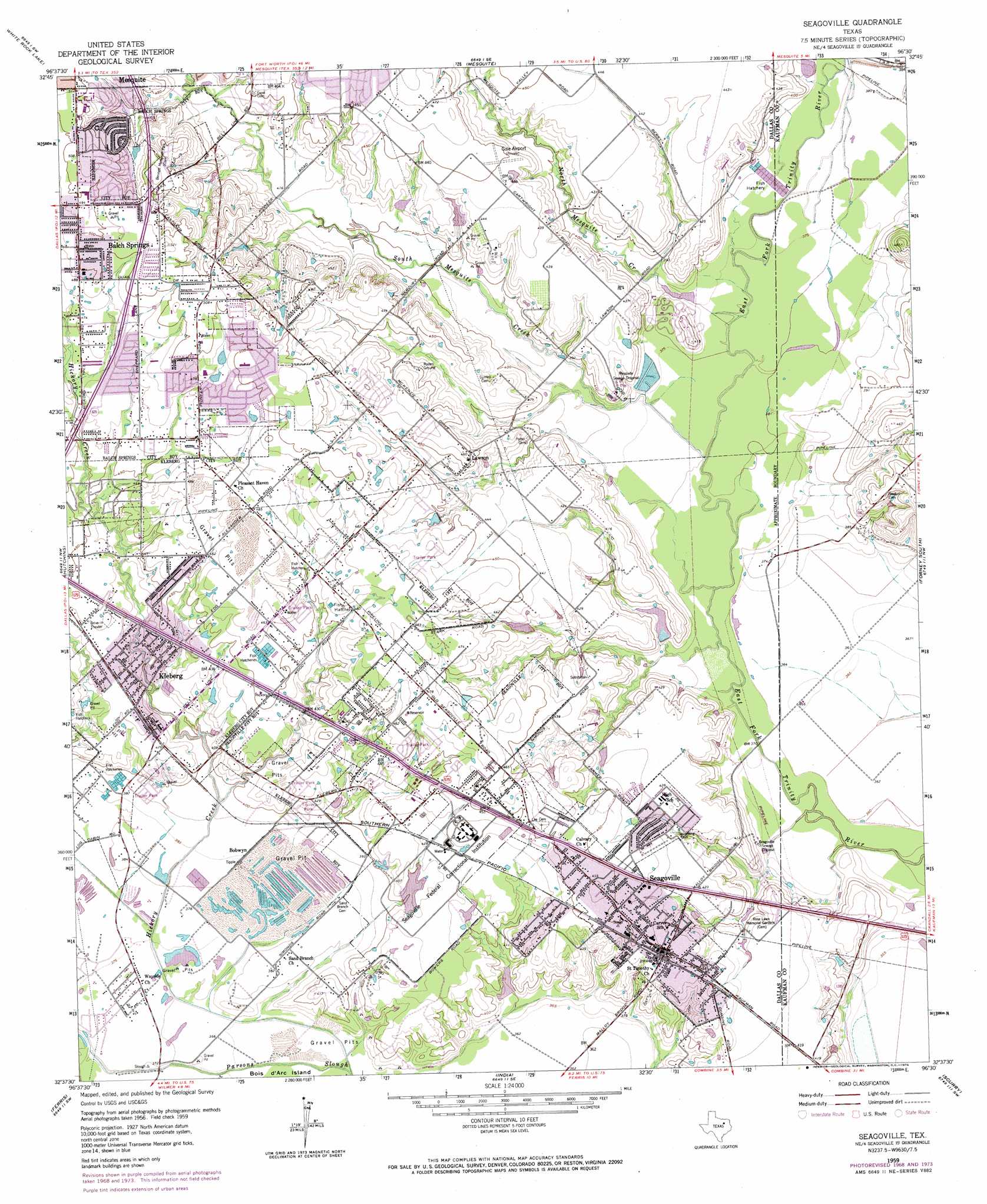
USGS Topo Quad 32096f5 - 1:24,000 scale
| Topo Map Name: | Seagoville |
| USGS Topo Quad ID: | 32096f5 |
| Print Size: | ca. 21 1/4" wide x 27" high |
| Southeast Coordinates: | 32.625° N latitude / 96.5° W longitude |
| Map Center Coordinates: | 32.6875° N latitude / 96.5625° W longitude |
| U.S. State: | TX |
| Filename: | o32096f5.jpg |
| Download Map JPG Image: | Seagoville topo map 1:24,000 scale |
| Map Type: | Topographic |
| Topo Series: | 7.5´ |
| Map Scale: | 1:24,000 |
| Source of Map Images: | United States Geological Survey (USGS) |
| Alternate Map Versions: |
Seagoville TX 1959, updated 1960 Download PDF Buy paper map Seagoville TX 1959, updated 1969 Download PDF Buy paper map Seagoville TX 1959, updated 1974 Download PDF Buy paper map Seagoville TX 1959, updated 1974 Download PDF Buy paper map Seagoville TX 2010 Download PDF Buy paper map Seagoville TX 2012 Download PDF Buy paper map Seagoville TX 2016 Download PDF Buy paper map |
1:24,000 Topo Quads surrounding Seagoville
Addison |
Garland |
Rowlett |
Rockwall |
Royse City |
Dallas |
White Rock Lake |
Mesquite |
Forney North |
Terrell North |
Oak Cliff |
Hutchins |
Seagoville |
Forney South |
Terrell South |
Lancaster |
Ferris |
India |
Scurry |
Kaufman |
Waxahachie |
Palmer |
Bristol |
Rosser |
Grays Prairie |
> Back to 32096e1 at 1:100,000 scale
> Back to 32096a1 at 1:250,000 scale
> Back to U.S. Topo Maps home
Seagoville topo map: Gazetteer
Seagoville: Airports
Creech Heliport elevation 123m 403′Kimi Heliport elevation 132m 433′
Phil L Hudson Municipal Airport elevation 135m 442′
Seagoville: Crossings
Interchange 1A elevation 137m 449′Interchange 1B elevation 144m 472′
Interchange 2 elevation 151m 495′
Interchange 3 elevation 145m 475′
Interchange 481 elevation 140m 459′
Interchange 482 elevation 153m 501′
Interchange 483 elevation 142m 465′
Interchange 487 elevation 134m 439′
Seagoville: Dams
Lake Number Nine Dam elevation 122m 400′Lawrence Lake Dam elevation 119m 390′
Lucas Lake Dam elevation 131m 429′
Soil Conservation Service Site 5 Dam elevation 117m 383′
Soil Conservation Service Site 6 Dam elevation 115m 377′
Seagoville: Parks
Beardon Park elevation 140m 459′Bruton Park elevation 128m 419′
Chiesl Baseball Complex elevation 137m 449′
Heard Park elevation 125m 410′
Hodges Park elevation 129m 423′
James Ray Henry Stadium elevation 129m 423′
Lew Park elevation 155m 508′
McWhorter Park elevation 139m 456′
Seagoville: Populated Places
Balch Springs elevation 152m 498′Bobwyn elevation 118m 387′
Kleberg elevation 132m 433′
Lawson elevation 138m 452′
Seagoville elevation 134m 439′
Seagoville: Post Offices
Balch Springs Post Office elevation 148m 485′Kleberg Post Office elevation 140m 459′
Seagoville Post Office elevation 131m 429′
Seagoville: Reservoirs
Lawrence Lake elevation 119m 390′Lucas Lake elevation 131m 429′
Soil Conservation Service Site 5 Reservoir elevation 117m 383′
Soil Conservation Service Site 6 Reservoir elevation 115m 377′
Seagoville: Streams
Hickory Creek elevation 110m 360′North Mesquite Creek elevation 113m 370′
South Mesquite Creek elevation 110m 360′
Seagoville: Trails
Valley Creek Greenbelt Trail elevation 125m 410′Seagoville digital topo map on disk
Buy this Seagoville topo map showing relief, roads, GPS coordinates and other geographical features, as a high-resolution digital map file on DVD: