White Rock Lake Topo Map Texas
To zoom in, hover over the map of White Rock Lake
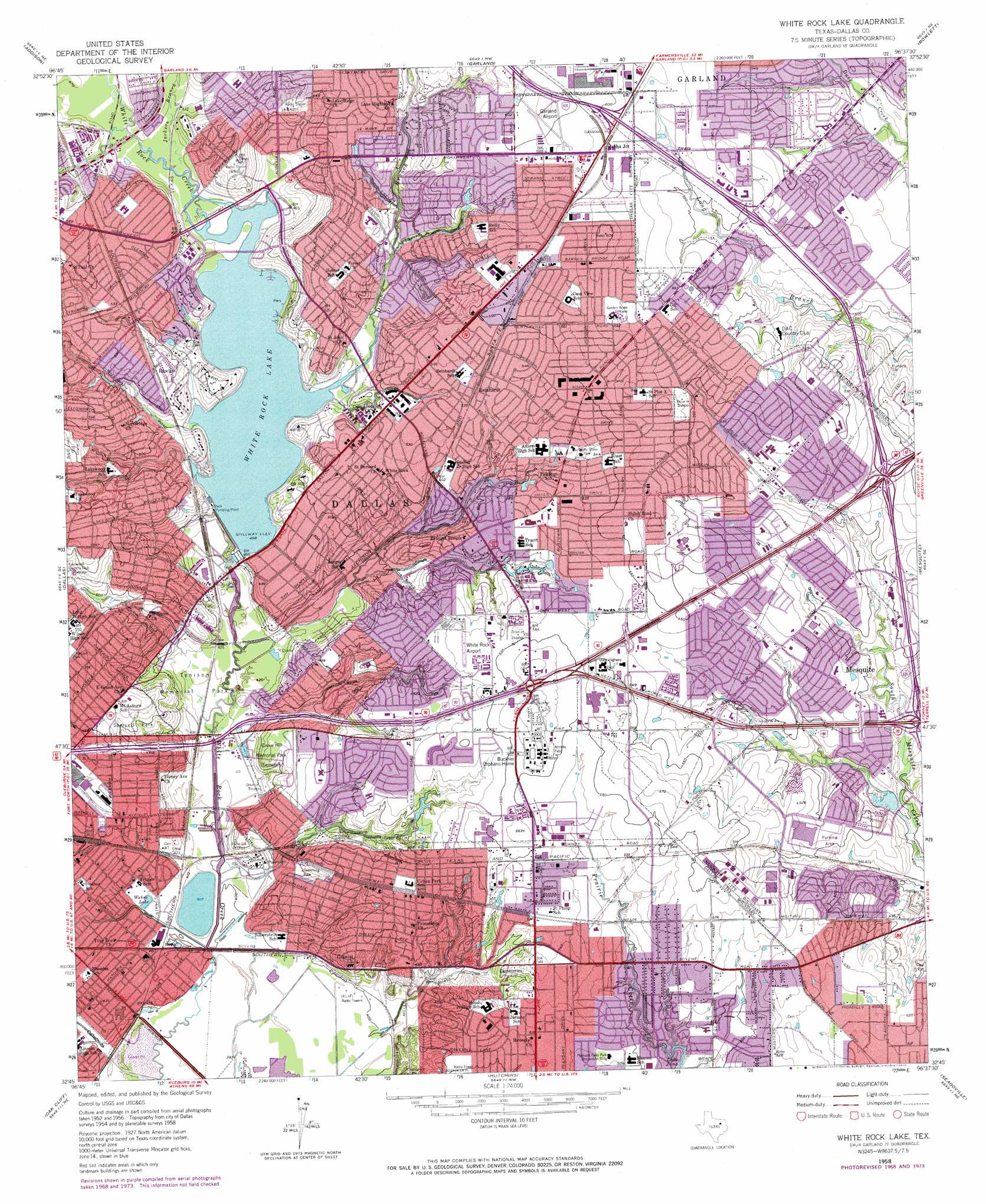
USGS Topo Quad 32096g6 - 1:24,000 scale
| Topo Map Name: | White Rock Lake |
| USGS Topo Quad ID: | 32096g6 |
| Print Size: | ca. 21 1/4" wide x 27" high |
| Southeast Coordinates: | 32.75° N latitude / 96.625° W longitude |
| Map Center Coordinates: | 32.8125° N latitude / 96.6875° W longitude |
| U.S. State: | TX |
| Filename: | o32096g6.jpg |
| Download Map JPG Image: | White Rock Lake topo map 1:24,000 scale |
| Map Type: | Topographic |
| Topo Series: | 7.5´ |
| Map Scale: | 1:24,000 |
| Source of Map Images: | United States Geological Survey (USGS) |
| Alternate Map Versions: |
White Rock Lake TX 1957, updated 1959 Download PDF Buy paper map White Rock Lake TX 1957, updated 1967 Download PDF Buy paper map White Rock Lake TX 1957, updated 1969 Download PDF Buy paper map White Rock Lake TX 1958, updated 1974 Download PDF Buy paper map White Rock Lake TX 1958, updated 1974 Download PDF Buy paper map White Rock Lake TX 1995, updated 2002 Download PDF Buy paper map White Rock Lake TX 2010 Download PDF Buy paper map White Rock Lake TX 2012 Download PDF Buy paper map White Rock Lake TX 2016 Download PDF Buy paper map |
1:24,000 Topo Quads surrounding White Rock Lake
Lewisville East |
Hebron |
Plano |
Wylie |
Lavon |
Carrollton |
Addison |
Garland |
Rowlett |
Rockwall |
Irving |
Dallas |
White Rock Lake |
Mesquite |
Forney North |
Duncanville |
Oak Cliff |
Hutchins |
Seagoville |
Forney South |
Cedar Hill |
Lancaster |
Ferris |
India |
Scurry |
> Back to 32096e1 at 1:100,000 scale
> Back to 32096a1 at 1:250,000 scale
> Back to U.S. Topo Maps home
White Rock Lake topo map: Gazetteer
White Rock Lake: Airports
Fire Department Training Center Heliport elevation 127m 416′White Rock Lake: Crossings
Interchange 11A elevation 168m 551′Interchange 11B elevation 171m 561′
Interchange 12 elevation 179m 587′
Interchange 13 elevation 181m 593′
Interchange 14 elevation 181m 593′
Interchange 49B elevation 127m 416′
Interchange 50 elevation 131m 429′
Interchange 51 elevation 159m 521′
Interchange 52A elevation 165m 541′
Interchange 52B elevation 171m 561′
Interchange 52C elevation 170m 557′
Interchange 53 elevation 165m 541′
Interchange 54 elevation 165m 541′
Interchange 55 elevation 166m 544′
Interchange 56A elevation 159m 521′
Interchange 6A and 6B elevation 146m 479′
Interchange 7 elevation 156m 511′
Interchange 8A and 8B elevation 162m 531′
Interchange 9A elevation 158m 518′
White Rock Lake: Dams
Parkdale Storage Pond Dam elevation 125m 410′White Rock Dam elevation 137m 449′
White Rock Lake: Lakes
Wahoo Lake elevation 125m 410′White Rock Lake elevation 140m 459′
White Rock Lake: Parks
Baker Park elevation 152m 498′Bass Park elevation 147m 482′
Bel - Aire Park elevation 146m 479′
Casa Linda Park elevation 151m 495′
Casa View Park elevation 174m 570′
Charger Stadium elevation 162m 531′
Everglade Park elevation 160m 524′
Fair Oaks Park elevation 143m 469′
Ferguson Road Park elevation 160m 524′
First Baptist Athletic Complex elevation 173m 567′
Flag Pole Hill Park elevation 156m 511′
Florence Park elevation 165m 541′
Forester Field elevation 163m 534′
Galloway Park elevation 150m 492′
Gateway Park elevation 126m 413′
Glover Park elevation 138m 452′
Harry Stone Park elevation 165m 541′
Hillview Park elevation 160m 524′
John C Albers Athletic Center elevation 152m 498′
Juanita Craft Park elevation 126m 413′
Lagow Park elevation 127m 416′
Lake Highland Park elevation 143m 469′
Lakeland Hill Park elevation 163m 534′
Lawnview Park elevation 121m 396′
Lindsley Park elevation 143m 469′
Lochwood Park elevation 164m 538′
Lon Wynne Park elevation 150m 492′
McCree Park elevation 163m 534′
McKenzie Park elevation 156m 511′
Mesquite Memorial Stadium elevation 159m 521′
Motley Park elevation 165m 541′
Nelson Park elevation 122m 400′
Norbuck Park elevation 144m 472′
Owenwood Park elevation 150m 492′
Parkdale Park elevation 139m 456′
Parkview Park elevation 146m 479′
Pleasant Oaks Park elevation 156m 511′
Range Park elevation 156m 511′
Ridge Wood Park elevation 162m 531′
Roffino Stadium elevation 162m 531′
Rugel Park elevation 145m 475′
Saint Francis Park elevation 132m 433′
Samuel Garland Park elevation 180m 590′
Samuell Park elevation 156m 511′
Seabourn Park elevation 159m 521′
Shands Park elevation 169m 554′
Terry Park elevation 128m 419′
Tokalon Park elevation 131m 429′
Tosch Park elevation 157m 515′
Town East Park elevation 147m 482′
Troth Abion Park elevation 147m 482′
Urban Park elevation 149m 488′
Urbandale Park elevation 153m 501′
Vanston Park elevation 164m 538′
Wahoo Park elevation 124m 406′
Warrior Field elevation 129m 423′
Westover Park elevation 140m 459′
White Rock East Park elevation 141m 462′
White Rock Lake Park elevation 140m 459′
White Rock West Park elevation 141m 462′
White Rock Lake: Populated Places
Rawlins elevation 155m 508′Reinhardt elevation 164m 538′
Zacha Junction elevation 179m 587′
White Rock Lake: Post Offices
Lakeland Hills Post Office elevation 139m 456′Parkdale Post Office elevation 157m 515′
Vickery Post Office elevation 152m 498′
White Rock Post Office elevation 162m 531′
White Rock Lake: Reservoirs
White Rock Lake elevation 137m 449′White Rock Lake: Streams
Dixon Branch elevation 140m 459′Jackson Branch elevation 140m 459′
White Rock Lake: Trails
Debusk Park Trail elevation 139m 456′Town East Park Trail elevation 153m 501′
White Rock Lake Trail elevation 143m 469′
White Rock Lake digital topo map on disk
Buy this White Rock Lake topo map showing relief, roads, GPS coordinates and other geographical features, as a high-resolution digital map file on DVD: