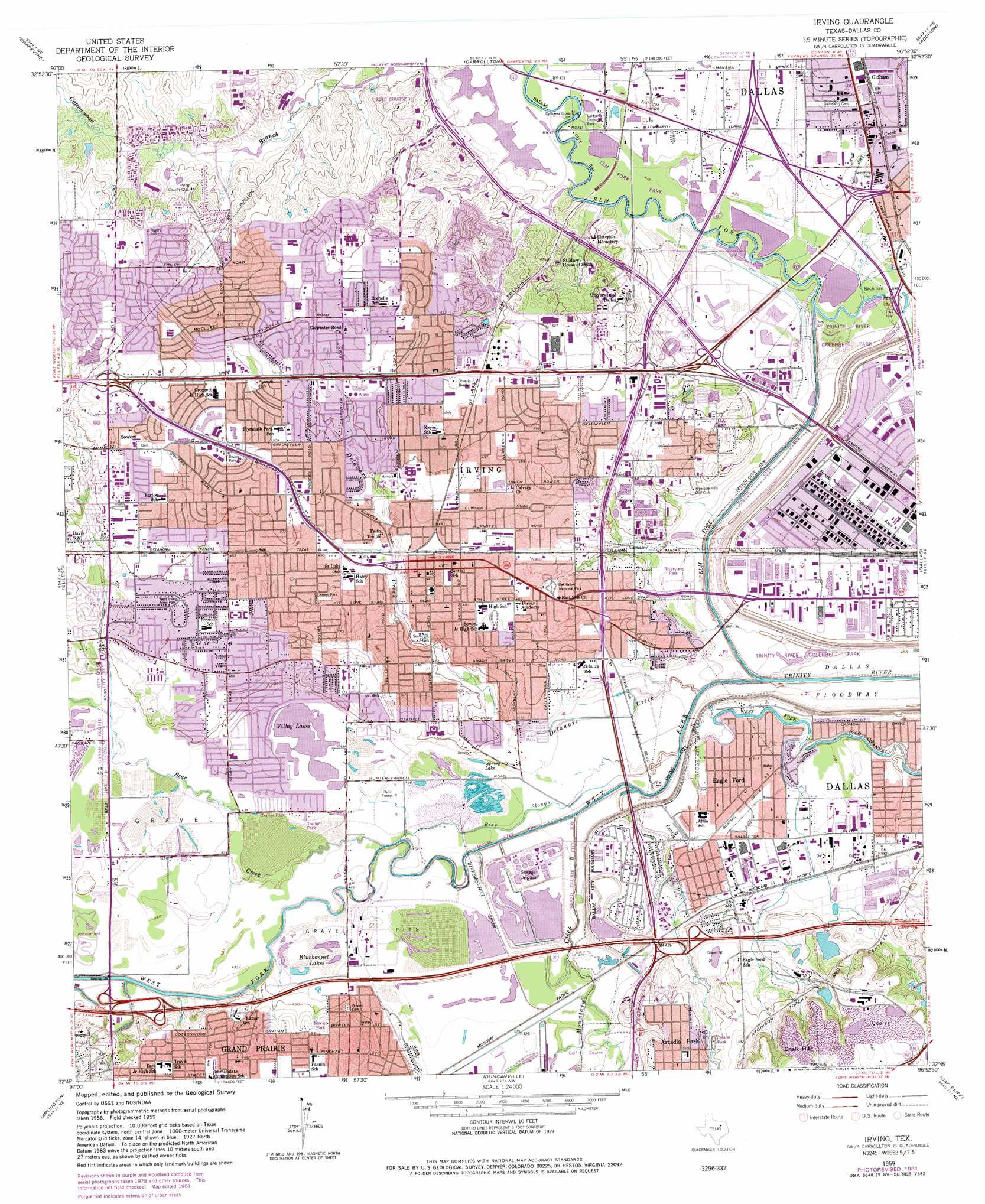
Irving Topo Map Texas
To zoom in, hover over the map of Irving
USGS Topo Quad 32096g8 - 1:24,000 scale
| Topo Map Name: | Irving |
| USGS Topo Quad ID: | 32096g8 |
| Print Size: | ca. 21 1/4" wide x 27" high |
| Southeast Coordinates: | 32.75° N latitude / 96.875° W longitude |
| Map Center Coordinates: | 32.8125° N latitude / 96.9375° W longitude |
| U.S. State: | TX |
| Filename: | o32096g8.jpg |
| Download Map JPG Image: | Irving topo map 1:24,000 scale |
| Map Type: | Topographic |
| Topo Series: | 7.5´ |
| Map Scale: | 1:24,000 |
| Source of Map Images: | United States Geological Survey (USGS) |
| Alternate Map Versions: |
Irving TX 1959, updated 1960 Download PDF Buy paper map Irving TX 1959, updated 1969 Download PDF Buy paper map Irving TX 1959, updated 1969 Download PDF Buy paper map Irving TX 1959, updated 1974 Download PDF Buy paper map Irving TX 1959, updated 1982 Download PDF Buy paper map Irving TX 1995, updated 2002 Download PDF Buy paper map Irving TX 2010 Download PDF Buy paper map Irving TX 2012 Download PDF Buy paper map Irving TX 2016 Download PDF Buy paper map |
1:24,000 Topo Quads surrounding Irving
Argyle |
Lewisville West |
Lewisville East |
Hebron |
Plano |
Colleyville |
Grapevine |
Carrollton |
Addison |
Garland |
Hurst |
Euless |
Irving |
Dallas |
White Rock Lake |
Kennedale |
Arlington |
Duncanville |
Oak Cliff |
Hutchins |
Mansfield |
Britton |
Cedar Hill |
Lancaster |
Ferris |
> Back to 32096e1 at 1:100,000 scale
> Back to 32096a1 at 1:250,000 scale
> Back to U.S. Topo Maps home
Irving topo map: Gazetteer
Irving: Airports
Dallas Rehabilitation Institute Heliport elevation 125m 410′Irving: Crossings
Field Circle Interchange elevation 132m 433′Interchange 34 elevation 135m 442′
Interchange 36 elevation 134m 439′
Interchange 38 elevation 131m 429′
Interchange 435 elevation 130m 426′
Interchange 436 elevation 130m 426′
Interchange 437 elevation 130m 426′
Irving: Dams
California Crossing Dam elevation 128m 419′Lake Carolyn Levee elevation 127m 416′
Las Colinas Reservoir Number 4 Dam elevation 141m 462′
Las Colinas Reservoir Number 7 Dam elevation 139m 456′
Texaco Dam elevation 143m 469′
Irving: Guts
Bear Slough elevation 129m 423′Irving: Lakes
Bluebonnet Lakes elevation 132m 433′Spring Lake elevation 128m 419′
Vilbig Lakes elevation 133m 436′
Irving: Parks
Bachman Lake Park elevation 123m 403′Bowles Park elevation 143m 469′
California Crossing Park elevation 128m 419′
Cistercian Preparatory School Baseball Field elevation 130m 426′
Cottonwood Creek Park elevation 150m 492′
Fannin Park elevation 150m 492′
Fritz Park elevation 133m 436′
Hawk Field elevation 127m 416′
Irving Schools Stadium elevation 146m 479′
Jaycee Park elevation 155m 508′
Keeler Park elevation 146m 479′
Lamar Park elevation 150m 492′
Live Oak Park elevation 137m 449′
Lively Park elevation 149m 488′
Luzon Park elevation 150m 492′
North Arcadia Park elevation 153m 501′
Northwest Park elevation 161m 528′
Plymouth Park elevation 156m 511′
Revere Park elevation 157m 515′
Senter Park elevation 140m 459′
Southwest Park elevation 148m 485′
Sunrise Park elevation 147m 482′
Texas Stadium (historical) elevation 135m 442′
The Highlands elevation 154m 505′
Tipton Park elevation 125m 410′
Trinity View Park elevation 126m 413′
Turner Park elevation 144m 472′
University of Dallas Baseball Field elevation 143m 469′
University of Dallas Soccer Field elevation 139m 456′
University of Dallas Softball Field elevation 139m 456′
Victoria Park elevation 173m 567′
West Irving Acres Park elevation 150m 492′
Woodridge Park elevation 170m 557′
Wyche Park elevation 161m 528′
YMCA Park elevation 157m 515′
Irving: Populated Places
Eagle Ford elevation 126m 413′Irving elevation 147m 482′
Oldham elevation 135m 442′
Sowers elevation 162m 531′
Irving: Post Offices
Brookhollow Post Office elevation 127m 416′Carl Range Post Office elevation 156m 511′
Central Irving Post Office elevation 150m 492′
Downtown Irving Post Office elevation 148m 485′
Las Colinas Post Office elevation 128m 419′
Northwest Dallas Post Office elevation 132m 433′
Irving: Reservoirs
Lake Carolyn elevation 127m 416′Las Colinas Reservoir Number 4 elevation 141m 462′
Las Colinas Reservoir Number 7 elevation 139m 456′
Texaco Lake elevation 143m 469′
Irving: Streams
Bachman Branch elevation 123m 403′Bear Creek elevation 127m 416′
Delaware Creek elevation 121m 396′
Elm Fork Trinity River elevation 121m 396′
Hackberry Creek elevation 128m 419′
Joes Creek elevation 125m 410′
Mountain Creek elevation 123m 403′
West Fork elevation 125m 410′
West Fork Trinity River elevation 121m 396′
Irving: Trails
L B Houston Park Nature Trail elevation 125m 410′Trinity Creek Mountain Creek Preserve Trail elevation 126m 413′
Irving digital topo map on disk
Buy this Irving topo map showing relief, roads, GPS coordinates and other geographical features, as a high-resolution digital map file on DVD: