Hillsboro East Topo Map Texas
To zoom in, hover over the map of Hillsboro East
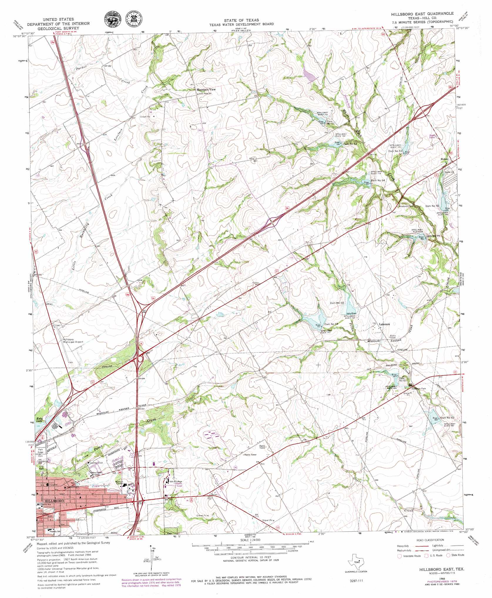
USGS Topo Quad 32097a1 - 1:24,000 scale
| Topo Map Name: | Hillsboro East |
| USGS Topo Quad ID: | 32097a1 |
| Print Size: | ca. 21 1/4" wide x 27" high |
| Southeast Coordinates: | 32° N latitude / 97° W longitude |
| Map Center Coordinates: | 32.0625° N latitude / 97.0625° W longitude |
| U.S. State: | TX |
| Filename: | o32097a1.jpg |
| Download Map JPG Image: | Hillsboro East topo map 1:24,000 scale |
| Map Type: | Topographic |
| Topo Series: | 7.5´ |
| Map Scale: | 1:24,000 |
| Source of Map Images: | United States Geological Survey (USGS) |
| Alternate Map Versions: |
Hillsboro East TX 1966, updated 1968 Download PDF Buy paper map Hillsboro East TX 1966, updated 1979 Download PDF Buy paper map Hillsboro East TX 2010 Download PDF Buy paper map Hillsboro East TX 2012 Download PDF Buy paper map Hillsboro East TX 2016 Download PDF Buy paper map |
1:24,000 Topo Quads surrounding Hillsboro East
Cleburne East |
Grandview |
Maypearl |
Boz |
Forreston |
Covington |
Itasca |
Files Valley |
Italy |
Avalon |
Blanton |
Hillsboro West |
Hillsboro East |
Mertens |
Frost |
Whitney |
Peoria |
Abbott |
Malone |
Irene |
Smiths Bend |
Aquilla |
West |
Penelope |
Hubbard |
> Back to 32097a1 at 1:100,000 scale
> Back to 32096a1 at 1:250,000 scale
> Back to U.S. Topo Maps home
Hillsboro East topo map: Gazetteer
Hillsboro East: Airports
Hillsboro Municipal Airport elevation 197m 646′Hillsboro East: Dams
Dam Number 51 elevation 221m 725′Dam Number 52 elevation 224m 734′
Dam Number 53 elevation 218m 715′
Dam Number 54 elevation 215m 705′
Dam Number 55 elevation 203m 666′
Dam Number 56 elevation 208m 682′
Dam Number 59 elevation 224m 734′
Dam Number 60 elevation 221m 725′
Dam Number 61 elevation 208m 682′
Dam Number 62 elevation 200m 656′
Isenberg Lake Dam elevation 197m 646′
Soil Conservation Service Site 17 Dam elevation 228m 748′
Soil Conservation Service Site 50 Dam elevation 221m 725′
Soil Conservation Service Site 51 Dam elevation 229m 751′
Soil Conservation Service Site 52 Dam elevation 224m 734′
Soil Conservation Service Site 53 Dam elevation 222m 728′
Soil Conservation Service Site 54 Dam elevation 215m 705′
Soil Conservation Service Site 55 Dam elevation 203m 666′
Soil Conservation Service Site 56 Dam elevation 207m 679′
Soil Conservation Service Site 59 Dam elevation 225m 738′
Soil Conservation Service Site 60 Dam elevation 218m 715′
Soil Conservation Service Site 61 Dam elevation 208m 682′
Soil Conservation Service Site 62 Dam elevation 201m 659′
Hillsboro East: Parks
Hill College elevation 226m 741′Hillsboro City Park elevation 180m 590′
Hillsboro East: Populated Places
Carls Corner elevation 222m 728′Lakenon elevation 226m 741′
Midway elevation 221m 725′
Mountain View elevation 253m 830′
Hillsboro East: Reservoirs
Isenberg Lake elevation 197m 646′Soil Conservation Service Site 17 Reservoir elevation 228m 748′
Soil Conservation Service Site 50 Reservoir elevation 221m 725′
Soil Conservation Service Site 51 Reservoir elevation 229m 751′
Soil Conservation Service Site 52 Reservoir elevation 224m 734′
Soil Conservation Service Site 53 Reservoir elevation 222m 728′
Soil Conservation Service Site 54 Reservoir elevation 215m 705′
Soil Conservation Service Site 55 Reservoir elevation 203m 666′
Soil Conservation Service Site 56 Reservoir elevation 207m 679′
Soil Conservation Service Site 59 Reservoir elevation 225m 738′
Soil Conservation Service Site 60 Reservoir elevation 218m 715′
Soil Conservation Service Site 61 Reservoir elevation 208m 682′
Soil Conservation Service Site 62 Reservoir elevation 201m 659′
Hillsboro East digital topo map on disk
Buy this Hillsboro East topo map showing relief, roads, GPS coordinates and other geographical features, as a high-resolution digital map file on DVD: