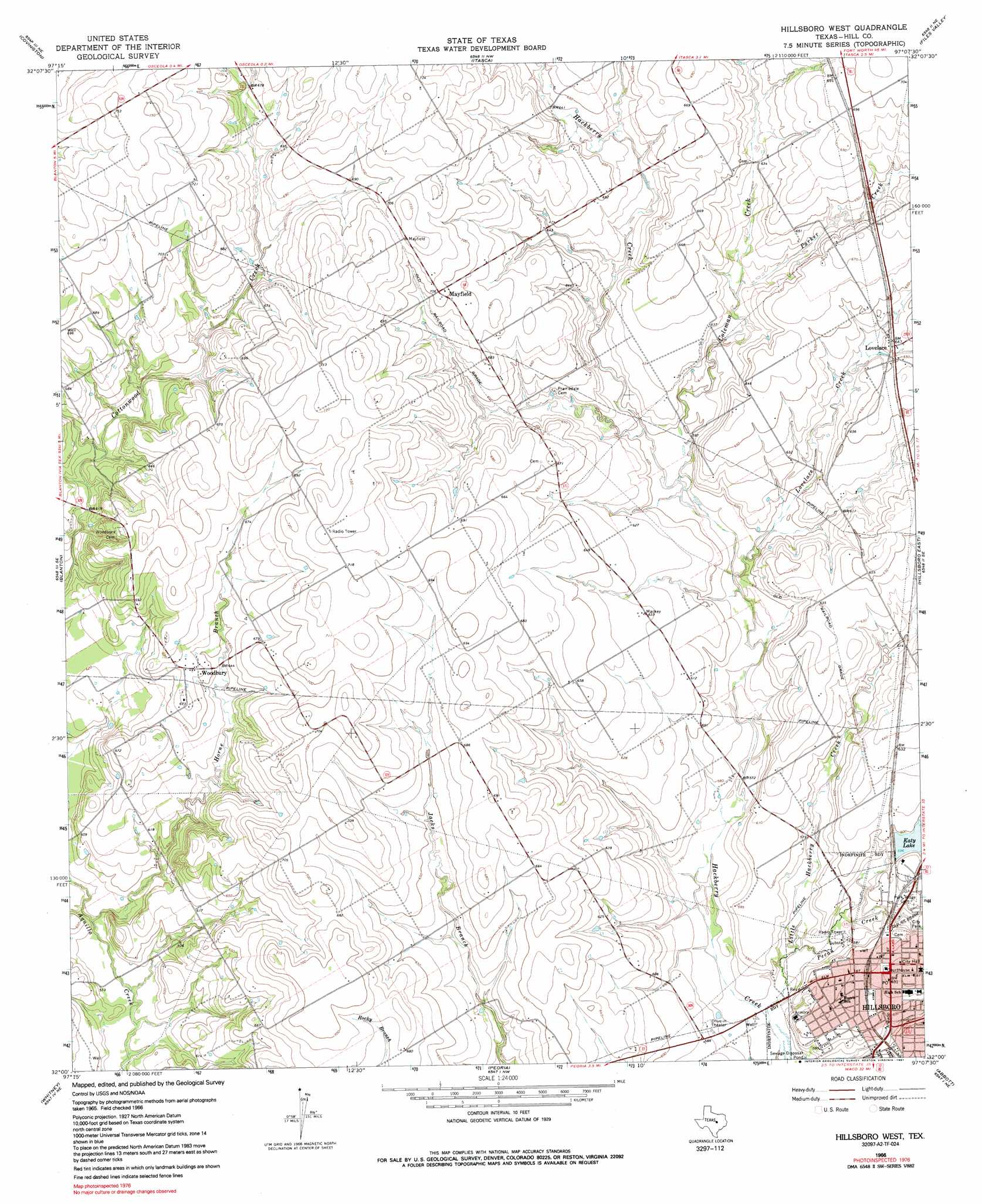
Hillsboro West Topo Map Texas
To zoom in, hover over the map of Hillsboro West
USGS Topo Quad 32097a2 - 1:24,000 scale
| Topo Map Name: | Hillsboro West |
| USGS Topo Quad ID: | 32097a2 |
| Print Size: | ca. 21 1/4" wide x 27" high |
| Southeast Coordinates: | 32° N latitude / 97.125° W longitude |
| Map Center Coordinates: | 32.0625° N latitude / 97.1875° W longitude |
| U.S. State: | TX |
| Filename: | o32097a2.jpg |
| Download Map JPG Image: | Hillsboro West topo map 1:24,000 scale |
| Map Type: | Topographic |
| Topo Series: | 7.5´ |
| Map Scale: | 1:24,000 |
| Source of Map Images: | United States Geological Survey (USGS) |
| Alternate Map Versions: |
Hillsboro West TX 1966, updated 1968 Download PDF Buy paper map Hillsboro West TX 1966, updated 1991 Download PDF Buy paper map Hillsboro West TX 2010 Download PDF Buy paper map Hillsboro West TX 2012 Download PDF Buy paper map Hillsboro West TX 2016 Download PDF Buy paper map |
1:24,000 Topo Quads surrounding Hillsboro West
Cleburne West |
Cleburne East |
Grandview |
Maypearl |
Boz |
Blum |
Covington |
Itasca |
Files Valley |
Italy |
Lakeside Village |
Blanton |
Hillsboro West |
Hillsboro East |
Mertens |
Allen Bend |
Whitney |
Peoria |
Abbott |
Malone |
Laguna Park |
Smiths Bend |
Aquilla |
West |
Penelope |
> Back to 32097a1 at 1:100,000 scale
> Back to 32096a1 at 1:250,000 scale
> Back to U.S. Topo Maps home
Hillsboro West topo map: Gazetteer
Hillsboro West: Dams
Hillsboro Lake Park Dam elevation 183m 600′Soil Conservation Service Grade Stabilization Structure 102 elevation 201m 659′
Soil Conservation Service Grade Stabilization Structure 105 elevation 204m 669′
Soil Conservation Service Grade Stabilization Structure 106 elevation 201m 659′
Soil Conservation Service Grade Stabilization Structure 11-3 elevation 210m 688′
Soil Conservation Service Grade Stabilization Structure 15-1 elevation 205m 672′
Soil Conservation Service Grade Stabilization Structure 20-1 elevation 193m 633′
Soil Conservation Service Site 15 Dam elevation 195m 639′
Soil Conservation Service Site 19a Dam elevation 188m 616′
Soil Conservation Service Site 20 Dam elevation 180m 590′
Hillsboro West: Populated Places
Hillsboro elevation 193m 633′Lovelace elevation 196m 643′
Mayfield elevation 214m 702′
Woodbury elevation 202m 662′
Hillsboro West: Post Offices
United States Post Office elevation 192m 629′Hillsboro West: Reservoirs
Grade Stabilization Structure 102 Reservoir elevation 201m 659′Grade Stabilization Structure 105 Reservoir elevation 204m 669′
Grade Stabilization Structure 106 Reservoir elevation 201m 659′
Grade Stabilization Structure 15-1 Reservoir elevation 205m 672′
Grade Stabilization Structure 20-1 Reservoir elevation 193m 633′
Katy Lake elevation 183m 600′
Soil Conservation Service Site 15 Reservoir elevation 195m 639′
Soil Conservation Service Site 19a Reservoir elevation 188m 616′
Soil Conservation Service Site 20 Reservoir elevation 180m 590′
Hillsboro West: Streams
Coleman Creek elevation 179m 587′Horne Branch elevation 173m 567′
Little Hackberry Creek elevation 169m 554′
Lovelace Creek elevation 176m 577′
Parker Creek elevation 187m 613′
Pecan Creek elevation 170m 557′
Hillsboro West digital topo map on disk
Buy this Hillsboro West topo map showing relief, roads, GPS coordinates and other geographical features, as a high-resolution digital map file on DVD: