Anneta Topo Map Texas
To zoom in, hover over the map of Anneta
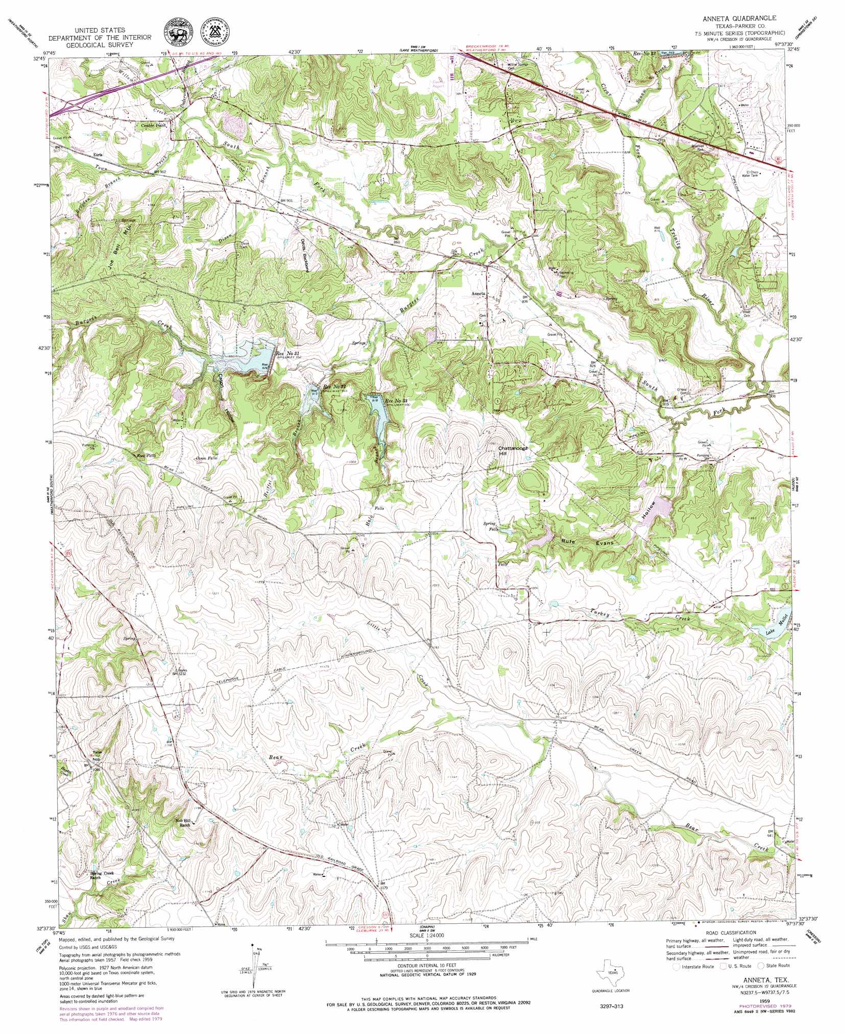
USGS Topo Quad 32097f6 - 1:24,000 scale
| Topo Map Name: | Anneta |
| USGS Topo Quad ID: | 32097f6 |
| Print Size: | ca. 21 1/4" wide x 27" high |
| Southeast Coordinates: | 32.625° N latitude / 97.625° W longitude |
| Map Center Coordinates: | 32.6875° N latitude / 97.6875° W longitude |
| U.S. State: | TX |
| Filename: | o32097f6.jpg |
| Download Map JPG Image: | Anneta topo map 1:24,000 scale |
| Map Type: | Topographic |
| Topo Series: | 7.5´ |
| Map Scale: | 1:24,000 |
| Source of Map Images: | United States Geological Survey (USGS) |
| Alternate Map Versions: |
Anneta TX 1959, updated 1960 Download PDF Buy paper map Anneta TX 1959, updated 1963 Download PDF Buy paper map Anneta TX 1959, updated 1979 Download PDF Buy paper map Annetta TX 2010 Download PDF Buy paper map Annetta TX 2012 Download PDF Buy paper map Annetta TX 2016 Download PDF Buy paper map |
1:24,000 Topo Quads surrounding Anneta
Adell |
Poolville |
Springtown |
Azle |
Avondale |
Garner |
Weatherford North |
Lake Weatherford |
Springtown Se |
Lake Worth |
Brock |
Weatherford South |
Anneta |
Aledo |
Benbrook |
Dennis |
Tin Top |
Chapin |
Cresson |
Primrose |
Tolar |
Granbury |
Acton |
Godley |
Joshua |
> Back to 32097e1 at 1:100,000 scale
> Back to 32096a1 at 1:250,000 scale
> Back to U.S. Topo Maps home
Anneta topo map: Gazetteer
Anneta: Airports
Clear Fork Ranch Heliport elevation 252m 826′Parker County Airport elevation 302m 990′
Trinity Meadows Race Track Heliport elevation 255m 836′
Anneta: Dams
Lake Moncrief Dam elevation 306m 1003′Lake Mullet Dam elevation 261m 856′
Meeker Lake Dam elevation 266m 872′
Moncrief Lake Dam elevation 301m 987′
Rufe Evans Lake Dam elevation 271m 889′
Soil Conservation Service Site 23 Dam elevation 261m 856′
Soil Conservation Service Site 31 Dam elevation 282m 925′
Soil Conservation Service Site 32 Dam elevation 302m 990′
Soil Conservation Service Site 33 Dam elevation 275m 902′
Anneta: Falls
Cason Falls elevation 315m 1033′Rock Falls elevation 321m 1053′
Spring Falls elevation 289m 948′
Anneta: Populated Places
Annetta elevation 265m 869′Annetta North elevation 262m 859′
Annetta South elevation 297m 974′
Center Point elevation 281m 921′
Earls elevation 277m 908′
Anneta: Reservoirs
El Chico Water Tank elevation 288m 944′Lake Moncrief elevation 306m 1003′
Lake Mullet elevation 263m 862′
Meeker Lake elevation 266m 872′
Moncrief Lake elevation 301m 987′
Reservoir Number Thirtyone elevation 293m 961′
Reservoir Number Thirtythree elevation 280m 918′
Reservoir Number Thritytwo elevation 278m 912′
Reservoir Number Twentythree elevation 266m 872′
Rufe Evans Lake elevation 271m 889′
Soil Conservation Service Site 23 Reservoir elevation 261m 856′
Soil Conservation Service Site 31 Reservoir elevation 282m 925′
Soil Conservation Service Site 32 Reservoir elevation 302m 990′
Soil Conservation Service Site 33 Reservoir elevation 275m 902′
Anneta: Ridges
Devils Backbone elevation 307m 1007′Anneta: Springs
Bear Creek Springs elevation 372m 1220′Anneta: Streams
Brogden Branch elevation 274m 898′Burgess Creek elevation 256m 839′
Dixon Branch elevation 268m 879′
Hale Branch elevation 266m 872′
Heiffel Branch elevation 270m 885′
Little Creek elevation 315m 1033′
Squaw Creek elevation 248m 813′
Town Creek elevation 240m 787′
Underwood Branch elevation 272m 892′
Willow Creek elevation 272m 892′
Anneta: Summits
Chattanooga Hill elevation 330m 1082′Joe Bell Mountain elevation 324m 1062′
Tater Nob elevation 344m 1128′
Anneta: Valleys
Cason Hollow elevation 286m 938′Rufe Evans Hollow elevation 247m 810′
Anneta digital topo map on disk
Buy this Anneta topo map showing relief, roads, GPS coordinates and other geographical features, as a high-resolution digital map file on DVD: