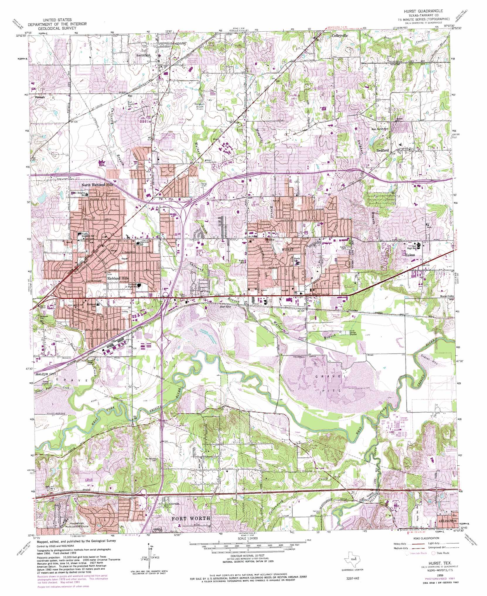
Hurst Topo Map Texas
To zoom in, hover over the map of Hurst
USGS Topo Quad 32097g2 - 1:24,000 scale
| Topo Map Name: | Hurst |
| USGS Topo Quad ID: | 32097g2 |
| Print Size: | ca. 21 1/4" wide x 27" high |
| Southeast Coordinates: | 32.75° N latitude / 97.125° W longitude |
| Map Center Coordinates: | 32.8125° N latitude / 97.1875° W longitude |
| U.S. State: | TX |
| Filename: | o32097g2.jpg |
| Download Map JPG Image: | Hurst topo map 1:24,000 scale |
| Map Type: | Topographic |
| Topo Series: | 7.5´ |
| Map Scale: | 1:24,000 |
| Source of Map Images: | United States Geological Survey (USGS) |
| Alternate Map Versions: |
Hurst TX 1959, updated 1961 Download PDF Buy paper map Hurst TX 1959, updated 1968 Download PDF Buy paper map Hurst TX 1959, updated 1969 Download PDF Buy paper map Hurst TX 1959, updated 1974 Download PDF Buy paper map Hurst TX 1959, updated 1982 Download PDF Buy paper map Hurst TX 1959, updated 1988 Download PDF Buy paper map Hurst TX 1995, updated 2001 Download PDF Buy paper map Hurst TX 2010 Download PDF Buy paper map Hurst TX 2012 Download PDF Buy paper map Hurst TX 2016 Download PDF Buy paper map |
1:24,000 Topo Quads surrounding Hurst
Rhome |
Justin |
Argyle |
Lewisville West |
Lewisville East |
Avondale |
Keller |
Colleyville |
Grapevine |
Carrollton |
Lake Worth |
Haltom City |
Hurst |
Euless |
Irving |
Benbrook |
Fort Worth |
Kennedale |
Arlington |
Duncanville |
Primrose |
Burleson |
Mansfield |
Britton |
Cedar Hill |
> Back to 32097e1 at 1:100,000 scale
> Back to 32096a1 at 1:250,000 scale
> Back to U.S. Topo Maps home
Hurst topo map: Gazetteer
Hurst: Airports
Bell Helicopter Hurst Heliport elevation 150m 492′Bell Helicopter Plant-3 Heliport elevation 157m 515′
Bell Helicopters Auxiliary Heliport elevation 144m 472′
Flight Safety Texas Heliport elevation 155m 508′
Fuller Airport elevation 146m 479′
H E B Hospital Heliport elevation 176m 577′
Heli-Dyne Systems Incorporated Heliport elevation 153m 501′
North Hills Medical Center Heliport elevation 175m 574′
Northeast Community Hospital Heliport elevation 179m 587′
TCJC-Northeast Campus Heliport elevation 184m 603′
Hurst: Crossings
Interchange 19 elevation 159m 521′Interchange 21A and 21B elevation 191m 626′
Interchange 21C elevation 204m 669′
Interchange 23 elevation 173m 567′
Interchange 24 elevation 159m 521′
Interchange 26 elevation 175m 574′
Hurst: Dams
Meadows Lakes East Lake Dam elevation 176m 577′Millbrook Addition Dam elevation 145m 475′
Prestonwood Lake Dam elevation 143m 469′
Village Creek Lake Dam elevation 143m 469′
Hurst: Parks
Barbrook Park elevation 155m 508′Barbrook Park elevation 156m 511′
Barrow Field elevation 188m 616′
Bellaire Park elevation 169m 554′
Billy Creek Estates Park elevation 158m 518′
Birdville Independent School District Complex elevation 183m 600′
Brook Hollow Park elevation 157m 515′
Cardinal Stadium - Fort Worth Christian School elevation 187m 613′
Carousel Park elevation 197m 646′
Central Drive Park elevation 179m 587′
Central Park elevation 162m 531′
Chisholm Park elevation 193m 633′
Echo - Hills Park elevation 186m 610′
Fort Worth Christian School Baseball Field elevation 189m 620′
Hurst Hills Park elevation 168m 551′
Jaycees Park elevation 163m 534′
Kate Baker Park elevation 171m 561′
Mayfair Park elevation 181m 593′
Norich Park elevation 181m 593′
Pennington Field elevation 183m 600′
Randol Mill Park elevation 166m 544′
Red Bud Park elevation 157m 515′
Richfield Park elevation 189m 620′
Richland Hills City Park elevation 153m 501′
Rosebud Park elevation 153m 501′
Sandybrook Park elevation 172m 564′
Smith Barfield Park elevation 172m 564′
Sparger Park elevation 176m 577′
Tesco Park elevation 158m 518′
Truett Linehan Field elevation 162m 531′
Valentine Park elevation 172m 564′
Wan-ka-kani Park elevation 163m 534′
Wells Park elevation 170m 557′
Windmill Park elevation 189m 620′
Hurst: Populated Places
Bedford elevation 182m 597′Ederville elevation 192m 629′
Hurst elevation 169m 554′
North Richland Hills elevation 184m 603′
Richland Hills elevation 173m 567′
Smithfield elevation 201m 659′
Hurst: Post Offices
Bedford Post Office elevation 188m 616′Central Bedford Post Office elevation 180m 590′
Hurst: Reservoirs
Meadows Lakes East Lake elevation 176m 577′Millbrook Addition Reservoir elevation 145m 475′
Prestonwood Lake elevation 143m 469′
Village Creek Lake elevation 143m 469′
Hurst: Streams
Big Fossil Creek elevation 144m 472′Calloway Branch elevation 152m 498′
Cottonwood Creek elevation 159m 521′
Little Fossil Creek elevation 146m 479′
Mesquite Branch elevation 149m 488′
Sulphur Branch elevation 142m 465′
Village Creek elevation 135m 442′
Walker Branch elevation 134m 439′
Hurst: Trails
Bedford Trails elevation 186m 610′Hurst digital topo map on disk
Buy this Hurst topo map showing relief, roads, GPS coordinates and other geographical features, as a high-resolution digital map file on DVD: