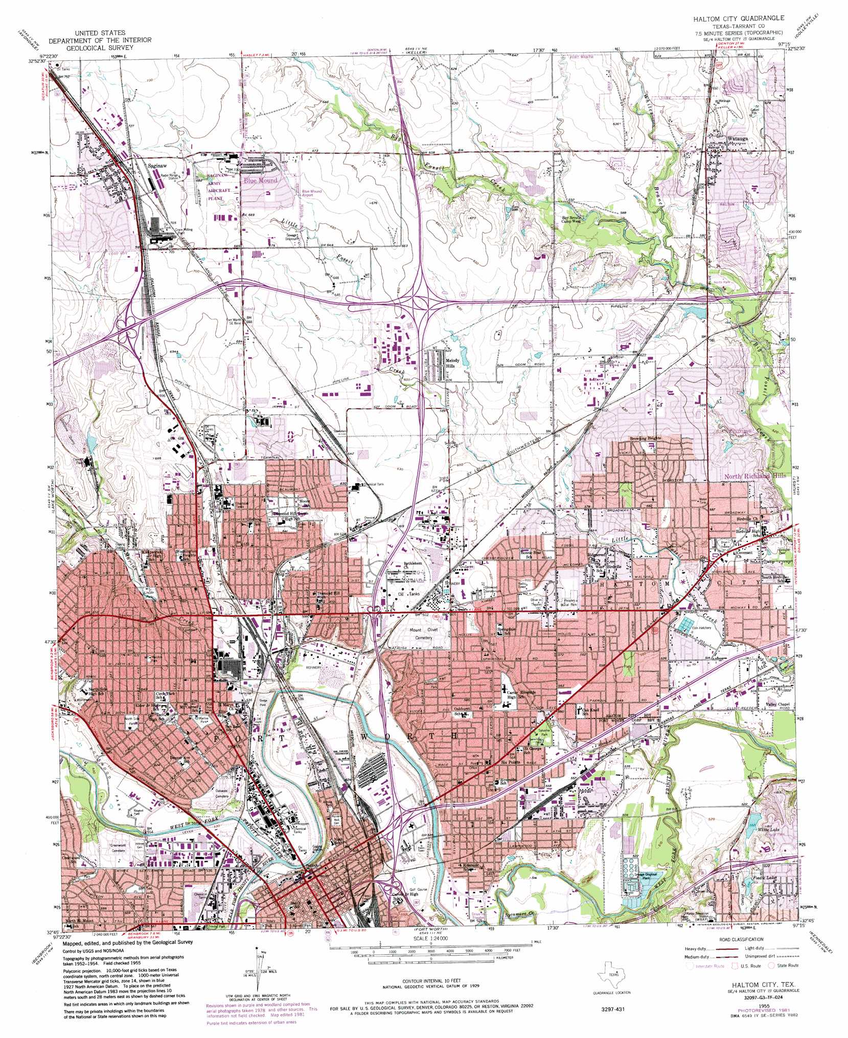
Haltom City Topo Map Texas
To zoom in, hover over the map of Haltom City
USGS Topo Quad 32097g3 - 1:24,000 scale
| Topo Map Name: | Haltom City |
| USGS Topo Quad ID: | 32097g3 |
| Print Size: | ca. 21 1/4" wide x 27" high |
| Southeast Coordinates: | 32.75° N latitude / 97.25° W longitude |
| Map Center Coordinates: | 32.8125° N latitude / 97.3125° W longitude |
| U.S. State: | TX |
| Filename: | o32097g3.jpg |
| Download Map JPG Image: | Haltom City topo map 1:24,000 scale |
| Map Type: | Topographic |
| Topo Series: | 7.5´ |
| Map Scale: | 1:24,000 |
| Source of Map Images: | United States Geological Survey (USGS) |
| Alternate Map Versions: |
Haltom City TX 1955 Download PDF Buy paper map Haltom City TX 1955, updated 1957 Download PDF Buy paper map Haltom City TX 1955, updated 1969 Download PDF Buy paper map Haltom City TX 1955, updated 1974 Download PDF Buy paper map Haltom City TX 1955, updated 1987 Download PDF Buy paper map Haltom City TX 1955, updated 1987 Download PDF Buy paper map Haltom City TX 1995, updated 2001 Download PDF Buy paper map Haltom City TX 2010 Download PDF Buy paper map Haltom City TX 2012 Download PDF Buy paper map Haltom City TX 2016 Download PDF Buy paper map |
1:24,000 Topo Quads surrounding Haltom City
Boyd |
Rhome |
Justin |
Argyle |
Lewisville West |
Azle |
Avondale |
Keller |
Colleyville |
Grapevine |
Springtown Se |
Lake Worth |
Haltom City |
Hurst |
Euless |
Aledo |
Benbrook |
Fort Worth |
Kennedale |
Arlington |
Cresson |
Primrose |
Burleson |
Mansfield |
Britton |
> Back to 32097e1 at 1:100,000 scale
> Back to 32096a1 at 1:250,000 scale
> Back to U.S. Topo Maps home
Haltom City topo map: Gazetteer
Haltom City: Airports
Action 5 Heliport elevation 192m 629′City of Fort Worth Heliport elevation 162m 531′
Fort Worth Meacham Airport elevation 207m 679′
Mallick Tower Heliport elevation 158m 518′
Southwest Regional Headquarters Heliport elevation 204m 669′
SW Region FAA Heliport elevation 183m 600′
Tandy Heliport elevation 161m 528′
Haltom City: Bridges
Paddock Viaduct elevation 157m 515′Haltom City: Crossings
Interchange 18 elevation 193m 633′Haltom City: Dams
Cement Creek Dam elevation 196m 643′Fosdic Lake Dam elevation 188m 616′
Knapp Lake Dam elevation 170m 557′
Nutt Dam elevation 160m 524′
Western Company Training Lagoon Dam elevation 191m 626′
White Lake Dam elevation 169m 554′
Haltom City: Parks
Arneson Park elevation 192m 629′Arnold Park elevation 179m 587′
Birdville Stadium elevation 161m 528′
Bonnie Brae Park elevation 179m 587′
Buck Sansom Park elevation 182m 597′
Burnett Park elevation 188m 616′
Circle Park elevation 182m 597′
Cold Spring Park elevation 161m 528′
Diamond Hill Park elevation 164m 538′
Fort Worth Convention Center elevation 187m 613′
Fossil Creek Park elevation 160m 524′
Greenway Park elevation 161m 528′
Greenwood Memorial Park elevation 164m 538′
Haltom City Park elevation 182m 597′
Harmon Field Park elevation 156m 511′
LaGrave Field elevation 164m 538′
Lincoln Park elevation 171m 561′
Linwood Park elevation 165m 541′
Little Fossil Park elevation 166m 544′
M G Ellis Park elevation 166m 544′
Marine Park elevation 170m 557′
Monticello Park elevation 178m 583′
Nolan Catholic High School Baseball Field elevation 184m 603′
Nolan Catholic High School Softball Fields elevation 177m 580′
North Park elevation 165m 541′
North Richland Hills City Park elevation 165m 541′
North Side Park elevation 189m 620′
Oakhurst Park elevation 186m 610′
Oakland Lake Park elevation 187m 613′
Paddock Park elevation 187m 613′
Peoples Burial Park elevation 177m 580′
Riverside Park elevation 160m 524′
Rockwood Park elevation 163m 534′
Rodeo Park elevation 165m 541′
Sandy Oak Park elevation 164m 538′
Springdale Park elevation 182m 597′
Sylvania Park elevation 171m 561′
Trader Oak Park elevation 170m 557′
Trail Drivers Park elevation 162m 531′
Viking Stadium elevation 172m 564′
WT Maddox Park elevation 203m 666′
Haltom City: Populated Places
Blue Mound elevation 205m 672′Haltom City elevation 163m 534′
Melody Hills elevation 189m 620′
Saginaw elevation 222m 728′
Watauga elevation 185m 606′
Haltom City: Reservoirs
Cement Creek Reservoir elevation 196m 643′Fosdic Lake elevation 183m 600′
Knapp Lake elevation 170m 557′
Nutt Lake elevation 160m 524′
Western Company Training Lagoon elevation 191m 626′
White Lake elevation 168m 551′
Haltom City: Streams
Clear Fork Trinity River elevation 156m 511′Marine Creek elevation 152m 498′
Sycamore Creek elevation 148m 485′
Whites Branch elevation 165m 541′
Haltom City: Trails
Gateway Park Trail elevation 156m 511′Haltom City digital topo map on disk
Buy this Haltom City topo map showing relief, roads, GPS coordinates and other geographical features, as a high-resolution digital map file on DVD: