Grapevine Topo Map Texas
To zoom in, hover over the map of Grapevine
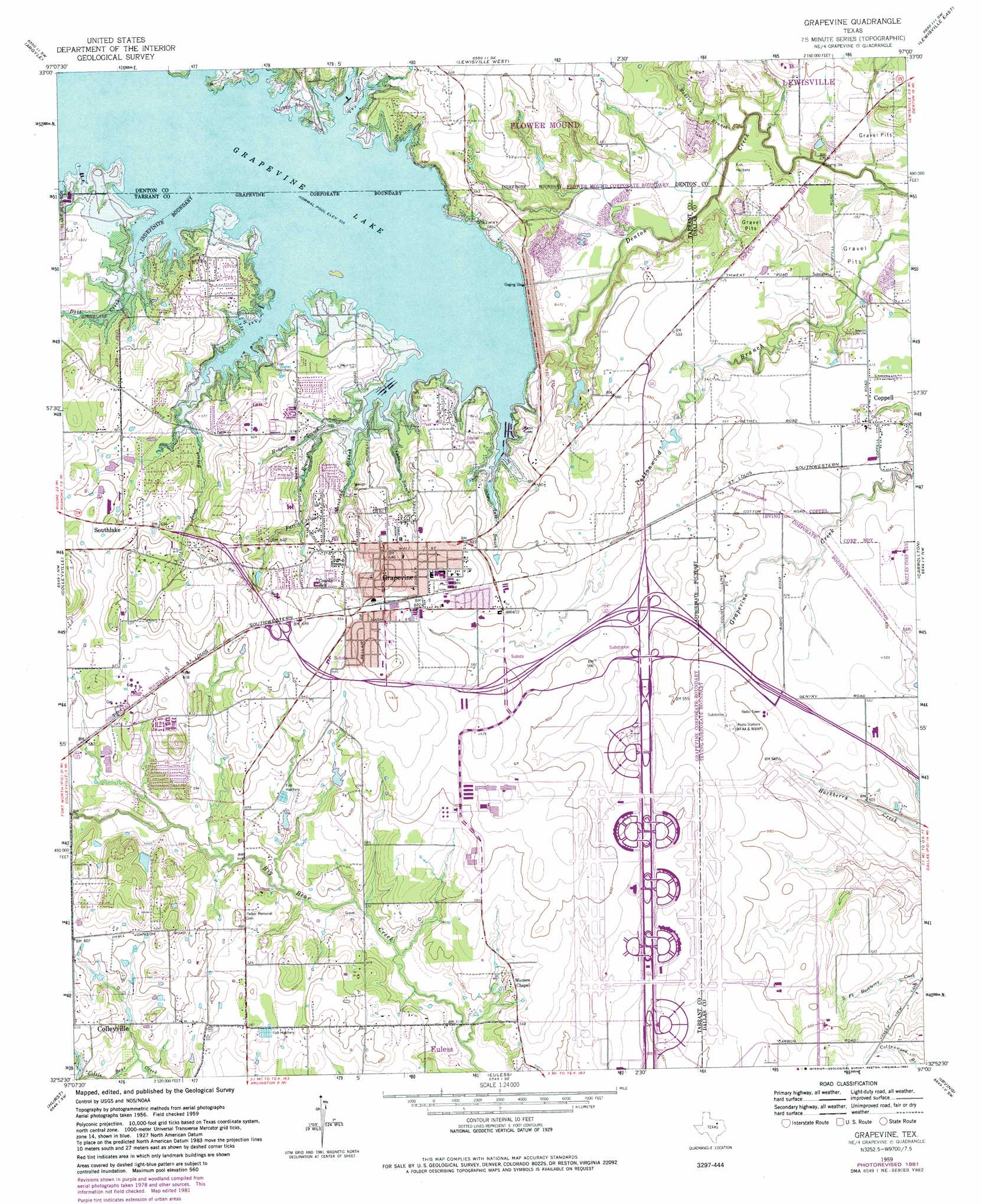
USGS Topo Quad 32097h1 - 1:24,000 scale
| Topo Map Name: | Grapevine |
| USGS Topo Quad ID: | 32097h1 |
| Print Size: | ca. 21 1/4" wide x 27" high |
| Southeast Coordinates: | 32.875° N latitude / 97° W longitude |
| Map Center Coordinates: | 32.9375° N latitude / 97.0625° W longitude |
| U.S. State: | TX |
| Filename: | o32097h1.jpg |
| Download Map JPG Image: | Grapevine topo map 1:24,000 scale |
| Map Type: | Topographic |
| Topo Series: | 7.5´ |
| Map Scale: | 1:24,000 |
| Source of Map Images: | United States Geological Survey (USGS) |
| Alternate Map Versions: |
Grapevine TX 1959, updated 1960 Download PDF Buy paper map Grapevine TX 1959, updated 1965 Download PDF Buy paper map Grapevine TX 1959, updated 1969 Download PDF Buy paper map Grapevine TX 1959, updated 1974 Download PDF Buy paper map Grapevine TX 1959, updated 1982 Download PDF Buy paper map Grapevine TX 2010 Download PDF Buy paper map Grapevine TX 2012 Download PDF Buy paper map Grapevine TX 2016 Download PDF Buy paper map |
1:24,000 Topo Quads surrounding Grapevine
Ponder |
Denton West |
Denton East |
Little Elm |
Frisco |
Justin |
Argyle |
Lewisville West |
Lewisville East |
Hebron |
Keller |
Colleyville |
Grapevine |
Carrollton |
Addison |
Haltom City |
Hurst |
Euless |
Irving |
Dallas |
Fort Worth |
Kennedale |
Arlington |
Duncanville |
Oak Cliff |
> Back to 32097e1 at 1:100,000 scale
> Back to 32096a1 at 1:250,000 scale
> Back to U.S. Topo Maps home
Grapevine topo map: Gazetteer
Grapevine: Airports
Dallas/Fort Worth International Airport elevation 178m 583′Grapevine: Crossings
Interchange 34 elevation 162m 531′Interchange 35 elevation 167m 547′
Interchange 36A elevation 170m 557′
Interchange 36B elevation 163m 534′
Grapevine: Dams
Grapevine Dam elevation 140m 459′H S Jackson Sand and Gravel Dam Number 1 elevation 149m 488′
Jackson Sand and Gravel Reservoir 1 Dam elevation 144m 472′
Grapevine: Parks
Andrew Brown Community Park elevation 143m 469′Banyan Park elevation 187m 613′
Bear Run Park elevation 165m 541′
Cluck Park elevation 186m 610′
Cowboy Stadium elevation 143m 469′
Dove Park elevation 190m 623′
Dragon Stadium elevation 192m 629′
Faith Christian School Football Field elevation 193m 633′
Grapevine Recreational Area elevation 143m 469′
Heritage Park elevation 181m 593′
Lake View Park elevation 166m 544′
Meadowmere Park elevation 168m 551′
Mustang-Panther Stadium elevation 183m 600′
Oak Grove Park elevation 176m 577′
Park Wood Park elevation 176m 577′
Parr Park elevation 169m 554′
Pecan Park elevation 186m 610′
Pickering Park elevation 188m 616′
Rockledge Park elevation 155m 508′
Silver Lake Park elevation 178m 583′
Yorkshire Meadows Park elevation 181m 593′
Grapevine: Populated Places
Coppell elevation 158m 518′Grapevine elevation 195m 639′
Minters Chapel elevation 171m 561′
Grapevine: Post Offices
Grapevine Post Office elevation 201m 659′Grapevine: Reservoirs
Grapevine Lake elevation 177m 580′Lake Number 1 elevation 149m 488′
Reservoir Number 1 elevation 144m 472′
Grapevine: Streams
Bakers Branch elevation 137m 449′Cable Branch elevation 163m 534′
Dove Creek elevation 163m 534′
Farris Branch elevation 167m 547′
Hudgens Branch elevation 163m 534′
Jones Branch elevation 163m 534′
Morehead Branch elevation 163m 534′
Silver Lake Branch elevation 163m 534′
Grapevine: Trails
Northshore Trail elevation 168m 551′Walnut Grove Trail elevation 167m 547′
Grapevine digital topo map on disk
Buy this Grapevine topo map showing relief, roads, GPS coordinates and other geographical features, as a high-resolution digital map file on DVD: