Lingleville Topo Map Texas
To zoom in, hover over the map of Lingleville
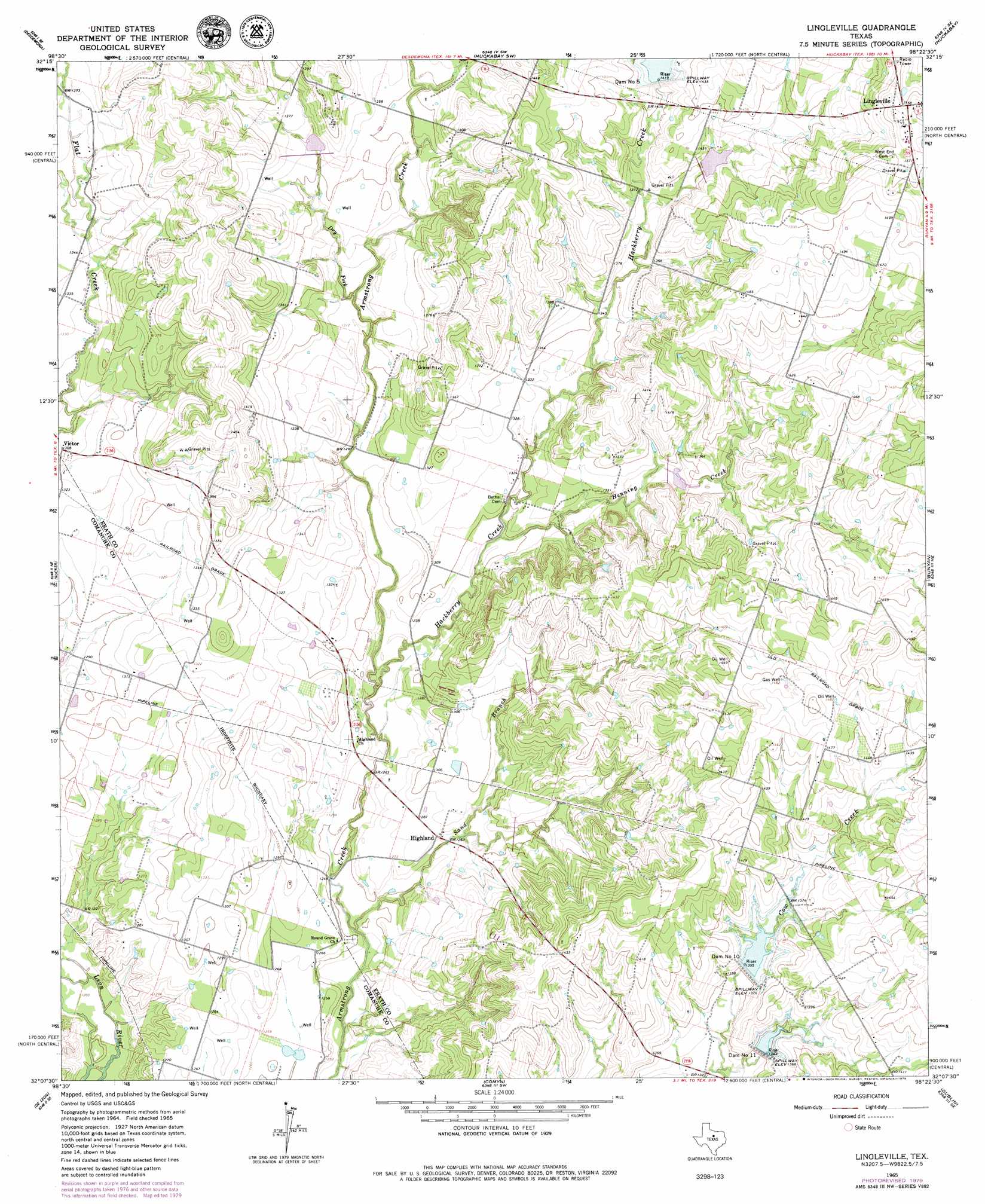
USGS Topo Quad 32098b4 - 1:24,000 scale
| Topo Map Name: | Lingleville |
| USGS Topo Quad ID: | 32098b4 |
| Print Size: | ca. 21 1/4" wide x 27" high |
| Southeast Coordinates: | 32.125° N latitude / 98.375° W longitude |
| Map Center Coordinates: | 32.1875° N latitude / 98.4375° W longitude |
| U.S. State: | TX |
| Filename: | o32098b4.jpg |
| Download Map JPG Image: | Lingleville topo map 1:24,000 scale |
| Map Type: | Topographic |
| Topo Series: | 7.5´ |
| Map Scale: | 1:24,000 |
| Source of Map Images: | United States Geological Survey (USGS) |
| Alternate Map Versions: |
Lingleville TX 1965, updated 1967 Download PDF Buy paper map Lingleville TX 1965, updated 1979 Download PDF Buy paper map Lingleville TX 2010 Download PDF Buy paper map Lingleville TX 2012 Download PDF Buy paper map Lingleville TX 2016 Download PDF Buy paper map |
1:24,000 Topo Quads surrounding Lingleville
Ranger |
Bear Mountain |
Reddy Mountain |
Turkey Creek |
Morgan Mill |
Kokomo |
Desdemona |
Huckabay Sw |
Huckabay |
Knob Hill |
Gorman |
Rucker |
Lingleville |
Bunyan |
Stephenville |
Duster |
De Leon |
Comyn |
Dublin |
Alexander |
Sidney |
Comanche |
Proctor |
Edna Hill |
Carlton |
> Back to 32098a1 at 1:100,000 scale
> Back to 32098a1 at 1:250,000 scale
> Back to U.S. Topo Maps home
Lingleville topo map: Gazetteer
Lingleville: Dams
Brooks Lake Dam elevation 429m 1407′Dam Number 10 elevation 416m 1364′
Dam Number 11 elevation 411m 1348′
Dam Number 5 elevation 435m 1427′
Soil Conservation Service Site 10 Dam elevation 413m 1354′
Soil Conservation Service Site 11 Dam elevation 418m 1371′
Soil Conservation Service Site 4 Dam elevation 414m 1358′
Soil Conservation Service Site 5 Dam elevation 430m 1410′
Soil Conservation Service Site 6 Dam elevation 430m 1410′
Soil Conservation Service Site 7 Dam elevation 401m 1315′
Soil Conservation Service Site 8 Dam elevation 403m 1322′
Soil Conservation Service Site 9 Dam elevation 391m 1282′
Lingleville: Populated Places
Highland elevation 390m 1279′Lingleville elevation 473m 1551′
Victor elevation 399m 1309′
Lingleville: Reservoirs
Brooks Lake elevation 429m 1407′Soil Conservation Service Site 10 Reservoir elevation 413m 1354′
Soil Conservation Service Site 11 Reservoir elevation 418m 1371′
Soil Conservation Service Site 4 Reservoir elevation 414m 1358′
Soil Conservation Service Site 5 Reservoir elevation 430m 1410′
Soil Conservation Service Site 6 Reservoir elevation 430m 1410′
Soil Conservation Service Site 7 Reservoir elevation 401m 1315′
Soil Conservation Service Site 8 Reservoir elevation 403m 1322′
Soil Conservation Service Site 9 Reservoir elevation 391m 1282′
Lingleville: Streams
Dry Fork elevation 396m 1299′Hackberry Creek elevation 382m 1253′
Henning Creek elevation 391m 1282′
Sand Branch elevation 375m 1230′
Lingleville digital topo map on disk
Buy this Lingleville topo map showing relief, roads, GPS coordinates and other geographical features, as a high-resolution digital map file on DVD: