Santo Topo Map Texas
To zoom in, hover over the map of Santo
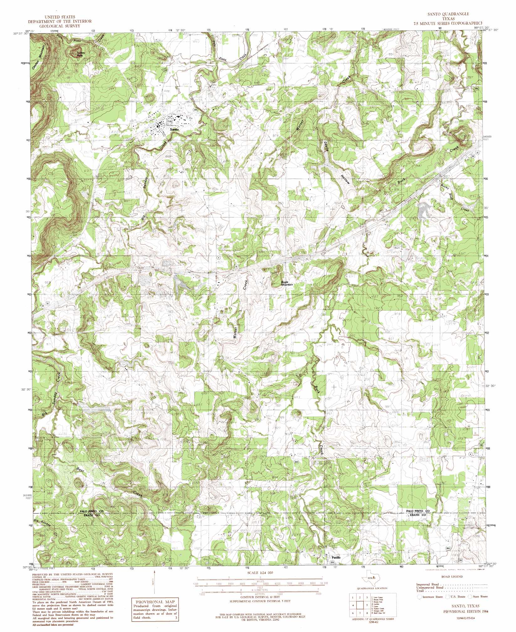
USGS Topo Quad 32098e2 - 1:24,000 scale
| Topo Map Name: | Santo |
| USGS Topo Quad ID: | 32098e2 |
| Print Size: | ca. 21 1/4" wide x 27" high |
| Southeast Coordinates: | 32.5° N latitude / 98.125° W longitude |
| Map Center Coordinates: | 32.5625° N latitude / 98.1875° W longitude |
| U.S. State: | TX |
| Filename: | o32098e2.jpg |
| Download Map JPG Image: | Santo topo map 1:24,000 scale |
| Map Type: | Topographic |
| Topo Series: | 7.5´ |
| Map Scale: | 1:24,000 |
| Source of Map Images: | United States Geological Survey (USGS) |
| Alternate Map Versions: |
Santo TX 1984, updated 1984 Download PDF Buy paper map Santo TX 1984, updated 1987 Download PDF Buy paper map Santo TX 2010 Download PDF Buy paper map Santo TX 2012 Download PDF Buy paper map Santo TX 2016 Download PDF Buy paper map |
1:24,000 Topo Quads surrounding Santo
Fortune Bend |
Palo Pinto |
Mineral Wells West |
Mineral Wells East |
Garner |
Metcalf Gap |
Lone Camp |
Brazos West |
Brazos East |
Brock |
Strawn East |
Gordon |
Santo |
Lipan |
Dennis |
Reddy Mountain |
Turkey Creek |
Morgan Mill |
Bluff Dale Ne |
Tolar |
Huckabay Sw |
Huckabay |
Knob Hill |
Bluff Dale |
Paluxy |
> Back to 32098e1 at 1:100,000 scale
> Back to 32098a1 at 1:250,000 scale
> Back to U.S. Topo Maps home
Santo topo map: Gazetteer
Santo: Dams
E J Porter Lake Dam elevation 272m 892′Lawrence Porter Lake Number 1 Dam elevation 279m 915′
Lawrence Porter Lake Number 2 Dam elevation 265m 869′
Lawrence Porter Lake Number 3 Dam elevation 276m 905′
Le Wallen Lake Number 1 Dam elevation 262m 859′
Le Wallen Lake Number 2 Dam elevation 263m 862′
Richards Lake Number 2 Dam elevation 266m 872′
Richards Lake Number 3 Dam elevation 297m 974′
Richards Lake Number 4 Dam elevation 281m 921′
Santo: Populated Places
Patillo elevation 308m 1010′Santo elevation 253m 830′
Santo: Reservoirs
E J Porter Lake elevation 272m 892′Lawrence Porter Lake Number 1 elevation 279m 915′
Lawrence Porter Lake Number 2 elevation 265m 869′
Lawrence Porter Lake Number 3 elevation 276m 905′
Le Wallen Lake Number 1 elevation 262m 859′
Le Wallen Lake Number 2 elevation 263m 862′
Richards Lake Number 2 elevation 266m 872′
Richards Lake Number 3 elevation 297m 974′
Richards Lake Number 4 elevation 281m 921′
Santo: Streams
Bear Creek elevation 265m 869′Big Sunday Creek elevation 240m 787′
Cantrell Creek elevation 237m 777′
Rocky Bluff Creek elevation 250m 820′
Santo: Summits
Bugle Mountain elevation 318m 1043′Turkey Peak elevation 320m 1049′
Santo: Valleys
Devils Hollow elevation 249m 816′Santo digital topo map on disk
Buy this Santo topo map showing relief, roads, GPS coordinates and other geographical features, as a high-resolution digital map file on DVD: