Mineral Wells West Topo Map Texas
To zoom in, hover over the map of Mineral Wells West
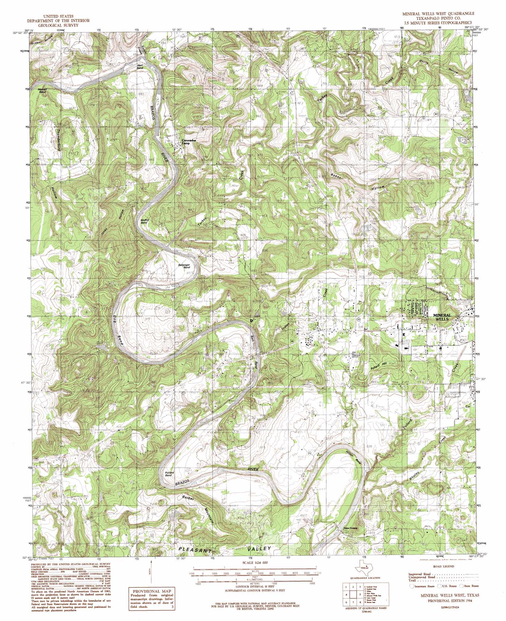
USGS Topo Quad 32098g2 - 1:24,000 scale
| Topo Map Name: | Mineral Wells West |
| USGS Topo Quad ID: | 32098g2 |
| Print Size: | ca. 21 1/4" wide x 27" high |
| Southeast Coordinates: | 32.75° N latitude / 98.125° W longitude |
| Map Center Coordinates: | 32.8125° N latitude / 98.1875° W longitude |
| U.S. State: | TX |
| Filename: | o32098g2.jpg |
| Download Map JPG Image: | Mineral Wells West topo map 1:24,000 scale |
| Map Type: | Topographic |
| Topo Series: | 7.5´ |
| Map Scale: | 1:24,000 |
| Source of Map Images: | United States Geological Survey (USGS) |
| Alternate Map Versions: |
Mineral Wells West TX 1984, updated 1984 Download PDF Buy paper map Mineral Wells West TX 1984, updated 1986 Download PDF Buy paper map Mineral Wells West TX 2010 Download PDF Buy paper map Mineral Wells West TX 2012 Download PDF Buy paper map Mineral Wells West TX 2016 Download PDF Buy paper map |
1:24,000 Topo Quads surrounding Mineral Wells West
Ross Mountain |
Long Hollow |
Bartons Chapel |
Perrin |
Gibtown |
Costello Island |
Graford West |
Graford East |
Whitt |
Adell |
Fortune Bend |
Palo Pinto |
Mineral Wells West |
Mineral Wells East |
Garner |
Metcalf Gap |
Lone Camp |
Brazos West |
Brazos East |
Brock |
Strawn East |
Gordon |
Santo |
Lipan |
Dennis |
> Back to 32098e1 at 1:100,000 scale
> Back to 32098a1 at 1:250,000 scale
> Back to U.S. Topo Maps home
Mineral Wells West topo map: Gazetteer
Mineral Wells West: Airports
Palo Pinto General Hospital Heliport elevation 272m 892′Mineral Wells West: Bends
Ballenger Bend elevation 252m 826′Bath Bend elevation 269m 882′
Dog Bend elevation 267m 875′
Hart Bend elevation 264m 866′
Hittson Bend elevation 258m 846′
Metcalf Bend elevation 271m 889′
Moffitt Bend elevation 260m 853′
Pollard Bend elevation 248m 813′
Mineral Wells West: Dams
Dike Lake Dam elevation 297m 974′Wilson Lake Dam elevation 294m 964′
Mineral Wells West: Flats
Pleasant Valley elevation 250m 820′Mineral Wells West: Parks
Elmhurst Park elevation 253m 830′Miller Stadium elevation 264m 866′
Mineral Wells Park elevation 287m 941′
Mineral Wells West: Populated Places
Coronados Camp elevation 261m 856′Mineral Wells West: Reservoirs
Dike Lake elevation 297m 974′Wilson Lake elevation 294m 964′
Mineral Wells West: Streams
Indian Creek elevation 242m 793′Keechi Creek elevation 248m 813′
Pollard Creek elevation 240m 787′
Turkey Creek elevation 245m 803′
Whatley Creek elevation 239m 784′
Mineral Wells West: Summits
Barber Mountain elevation 318m 1043′Pollard Hill elevation 308m 1010′
Mineral Wells West: Valleys
Baker Hollow elevation 266m 872′Birdwell Hollow elevation 256m 839′
Devils Hollow elevation 285m 935′
Jones Hollow elevation 253m 830′
Thunderburg Hollow elevation 259m 849′
Mineral Wells West digital topo map on disk
Buy this Mineral Wells West topo map showing relief, roads, GPS coordinates and other geographical features, as a high-resolution digital map file on DVD: