Cross Cut Topo Map Texas
To zoom in, hover over the map of Cross Cut
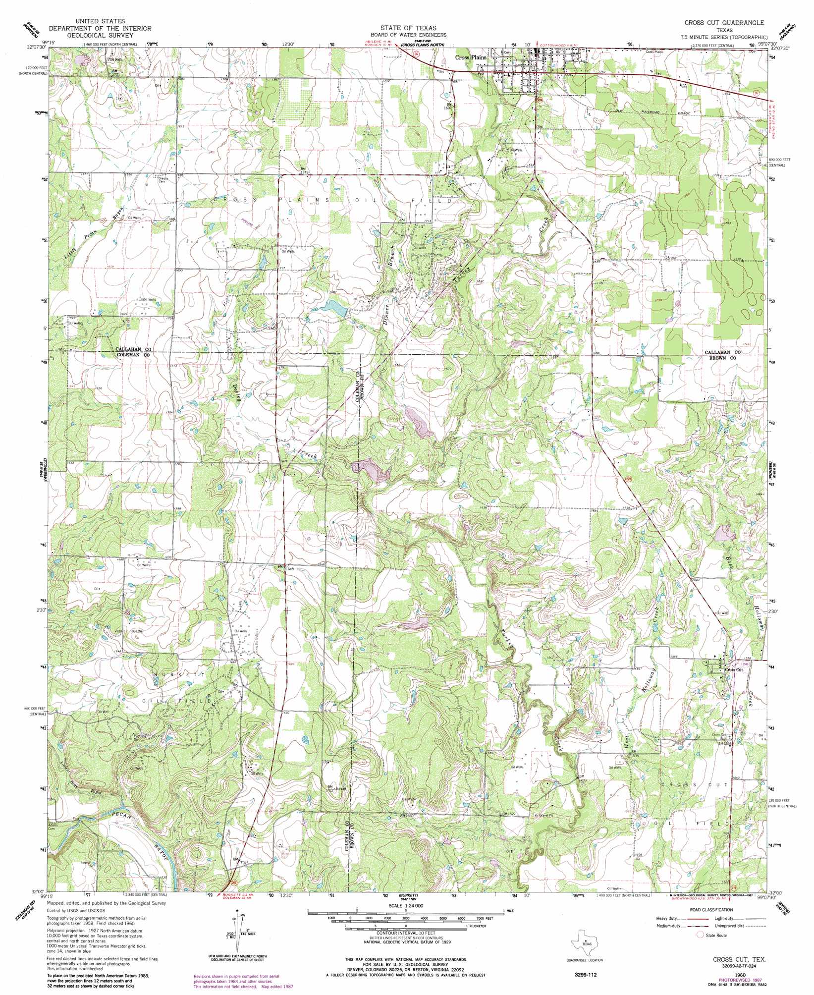
USGS Topo Quad 32099a2 - 1:24,000 scale
| Topo Map Name: | Cross Cut |
| USGS Topo Quad ID: | 32099a2 |
| Print Size: | ca. 21 1/4" wide x 27" high |
| Southeast Coordinates: | 32° N latitude / 99.125° W longitude |
| Map Center Coordinates: | 32.0625° N latitude / 99.1875° W longitude |
| U.S. State: | TX |
| Filename: | o32099a2.jpg |
| Download Map JPG Image: | Cross Cut topo map 1:24,000 scale |
| Map Type: | Topographic |
| Topo Series: | 7.5´ |
| Map Scale: | 1:24,000 |
| Source of Map Images: | United States Geological Survey (USGS) |
| Alternate Map Versions: |
Cross Cut TX 1960, updated 1962 Download PDF Buy paper map Cross Cut TX 1960, updated 1987 Download PDF Buy paper map Cross Cut TX 2010 Download PDF Buy paper map Cross Cut TX 2012 Download PDF Buy paper map Cross Cut TX 2016 Download PDF Buy paper map |
1:24,000 Topo Quads surrounding Cross Cut
Cub Hollow |
Admiral |
Putnam South |
Scranton |
Cisco South |
Rowden Nw |
Rowden |
Cross Plains North |
Sabanno |
Union Center |
Crooked Creek |
Webbville |
Cross Cut |
Pioneer |
Rising Star |
Lake Scarborough |
Coleman Ne |
Burkett |
Byrds |
May |
Coleman |
Lake San Tana |
Thrifty |
Lake Brownwood |
Owens |
> Back to 32099a1 at 1:100,000 scale
> Back to 32098a1 at 1:250,000 scale
> Back to U.S. Topo Maps home
Cross Cut topo map: Gazetteer
Cross Cut: Dams
McDonough Lake Dam elevation 518m 1699′Soil Conservation Service Site 10 Dam elevation 492m 1614′
Soil Conservation Service Site 11a Dam elevation 487m 1597′
Soil Conservation Service Site 12 Dam elevation 485m 1591′
Soil Conservation Service Site 22 Dam elevation 519m 1702′
Soil Conservation Service Site 26 Dam elevation 486m 1594′
Cross Cut: Oilfields
Burkett Oil Field elevation 499m 1637′Cross Plains Oil Field elevation 529m 1735′
Cross Cut: Populated Places
Cross Cut elevation 483m 1584′Cross Cut: Reservoirs
McDonough Lake elevation 518m 1699′Soil Conservation Service Site 10 Reservoir elevation 492m 1614′
Soil Conservation Service Site 11a Reservoir elevation 487m 1597′
Soil Conservation Service Site 12 Reservoir elevation 485m 1591′
Soil Conservation Service Site 22 Reservoir elevation 519m 1702′
Soil Conservation Service Site 26 Reservoir elevation 486m 1594′
Cross Cut: Streams
Dinner Branch elevation 489m 1604′Dooley Creek elevation 483m 1584′
Little Pecan Bayou elevation 467m 1532′
Cross Cut digital topo map on disk
Buy this Cross Cut topo map showing relief, roads, GPS coordinates and other geographical features, as a high-resolution digital map file on DVD: