Bald Knob Topo Map Texas
To zoom in, hover over the map of Bald Knob
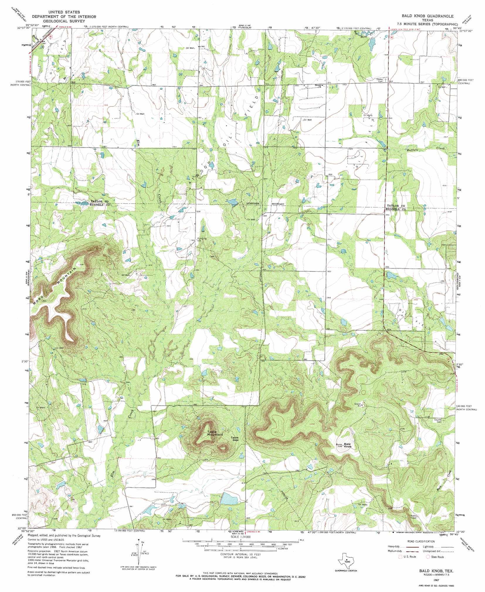
USGS Topo Quad 32099a7 - 1:24,000 scale
| Topo Map Name: | Bald Knob |
| USGS Topo Quad ID: | 32099a7 |
| Print Size: | ca. 21 1/4" wide x 27" high |
| Southeast Coordinates: | 32° N latitude / 99.75° W longitude |
| Map Center Coordinates: | 32.0625° N latitude / 99.8125° W longitude |
| U.S. State: | TX |
| Filename: | o32099a7.jpg |
| Download Map JPG Image: | Bald Knob topo map 1:24,000 scale |
| Map Type: | Topographic |
| Topo Series: | 7.5´ |
| Map Scale: | 1:24,000 |
| Source of Map Images: | United States Geological Survey (USGS) |
| Alternate Map Versions: |
Bald Knob TX 1967, updated 1979 Download PDF Buy paper map Bald Knob TX 2010 Download PDF Buy paper map Bald Knob TX 2012 Download PDF Buy paper map Bald Knob TX 2016 Download PDF Buy paper map |
1:24,000 Topo Quads surrounding Bald Knob
Mountain Pass |
View |
Buffalo Gap |
Potosi |
Eula |
Shep |
Lake Abilene |
Tuscola |
Lawn |
Oplin |
Wingate |
Bradshaw |
Bald Knob |
Goldsboro |
Mcewen Draw |
Wilmeth |
Winters |
Crews |
Novice West |
Novice East |
Herring Ranch |
Hatchel |
Benoit |
Talpa |
Valera |
> Back to 32099a1 at 1:100,000 scale
> Back to 32098a1 at 1:250,000 scale
> Back to U.S. Topo Maps home
Bald Knob topo map: Gazetteer
Bald Knob: Dams
Billups Lake Dam elevation 578m 1896′Bald Knob: Gaps
Table Gap elevation 591m 1938′Bald Knob: Oilfields
Atwood Oil Field elevation 590m 1935′Bald Knob: Reservoirs
Billups Lake elevation 578m 1896′Bald Knob: Summits
Bald Knob elevation 700m 2296′Moro Mountain elevation 700m 2296′
Table Mountain elevation 688m 2257′
Bald Knob digital topo map on disk
Buy this Bald Knob topo map showing relief, roads, GPS coordinates and other geographical features, as a high-resolution digital map file on DVD: