Bernie Lake Topo Map Texas
To zoom in, hover over the map of Bernie Lake
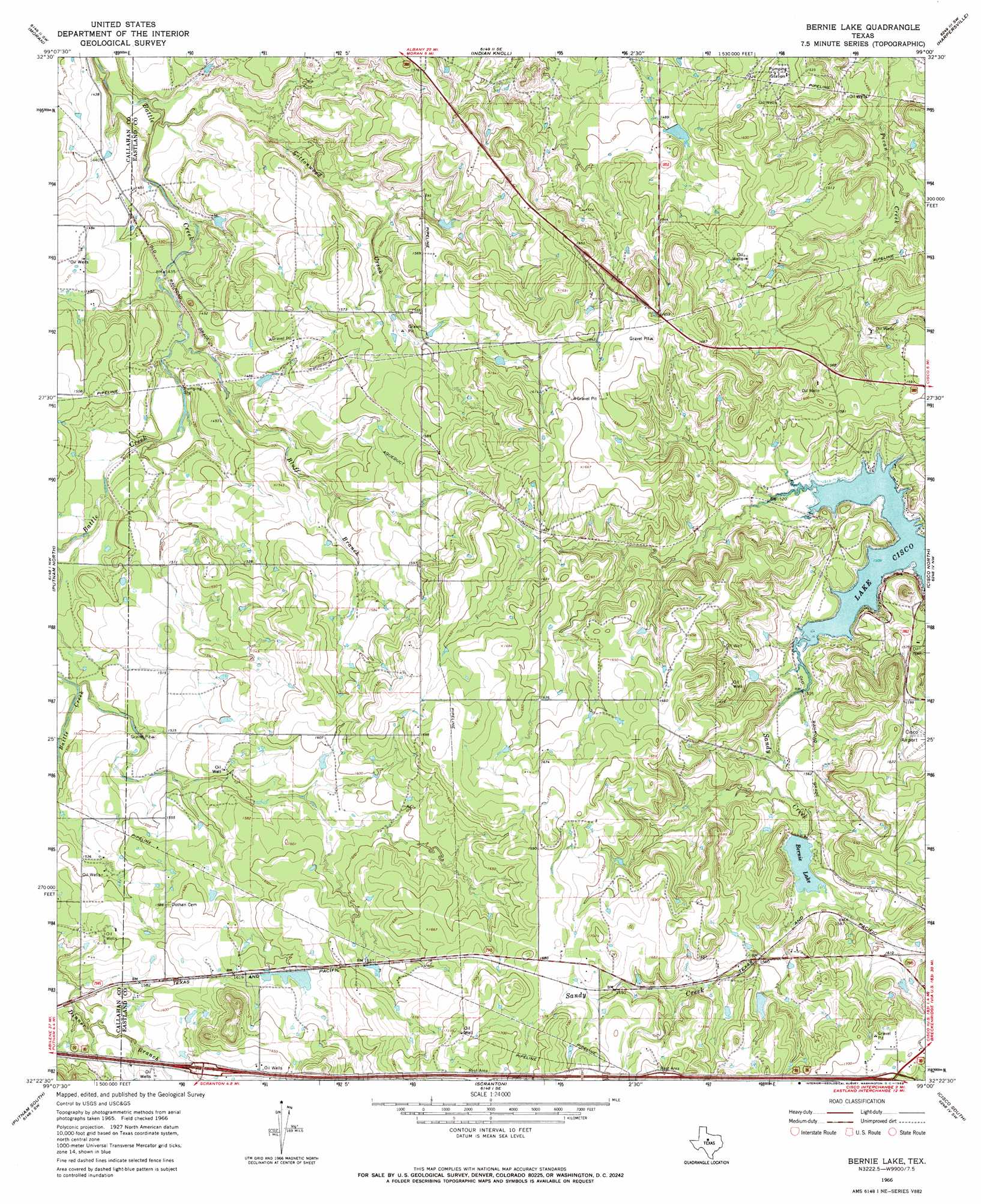
USGS Topo Quad 32099d1 - 1:24,000 scale
| Topo Map Name: | Bernie Lake |
| USGS Topo Quad ID: | 32099d1 |
| Print Size: | ca. 21 1/4" wide x 27" high |
| Southeast Coordinates: | 32.375° N latitude / 99° W longitude |
| Map Center Coordinates: | 32.4375° N latitude / 99.0625° W longitude |
| U.S. State: | TX |
| Filename: | o32099d1.jpg |
| Download Map JPG Image: | Bernie Lake topo map 1:24,000 scale |
| Map Type: | Topographic |
| Topo Series: | 7.5´ |
| Map Scale: | 1:24,000 |
| Source of Map Images: | United States Geological Survey (USGS) |
| Alternate Map Versions: |
Bernie Lake TX 1966, updated 1969 Download PDF Buy paper map Bernie Lake TX 2010 Download PDF Buy paper map Bernie Lake TX 2012 Download PDF Buy paper map Bernie Lake TX 2016 Download PDF Buy paper map |
1:24,000 Topo Quads surrounding Bernie Lake
Albany |
Mccathrine Mountain |
Eolian |
Buck Mountain |
Necessity |
Snyder Lake |
Moran |
Indian Knoll |
Harpersville |
Wayland |
Jayell |
Putnam North |
Bernie Lake |
Cisco North |
Eastland |
Admiral |
Putnam South |
Scranton |
Cisco South |
Carbon |
Rowden |
Cross Plains North |
Sabanno |
Union Center |
Hunting Shirt Creek |
> Back to 32099a1 at 1:100,000 scale
> Back to 32098a1 at 1:250,000 scale
> Back to U.S. Topo Maps home
Bernie Lake topo map: Gazetteer
Bernie Lake: Airports
Cisco Municipal Airport elevation 489m 1604′Bernie Lake: Dams
Cooper Lake Dam elevation 455m 1492′Dothan Water Station Levee elevation 504m 1653′
Kendall Lake Dam elevation 492m 1614′
Retention Dam elevation 445m 1459′
Bernie Lake: Populated Places
Pueblo elevation 435m 1427′Bernie Lake: Reservoirs
Battle Creek Channel Lake elevation 445m 1459′Bernie Lake elevation 478m 1568′
Cooper Lake elevation 455m 1492′
Dothan Water Station Lake elevation 504m 1653′
Kendall Lake elevation 492m 1614′
Bernie Lake: Streams
Bluff Branch elevation 434m 1423′Cottonwood Creek elevation 423m 1387′
Bernie Lake digital topo map on disk
Buy this Bernie Lake topo map showing relief, roads, GPS coordinates and other geographical features, as a high-resolution digital map file on DVD: