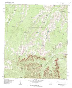
Mcwhorter Mountain Topo Map Texas
To zoom in, hover over the map of Mcwhorter Mountain
USGS Topo Quad 32100a8 - 1:24,000 scale
| Topo Map Name: | Mcwhorter Mountain |
| USGS Topo Quad ID: | 32100a8 |
| Print Size: | ca. 21 1/4" wide x 27" high |
| Southeast Coordinates: | 32° N latitude / 100.875° W longitude |
| Map Center Coordinates: | 32.0625° N latitude / 100.9375° W longitude |
| U.S. State: | TX |
| Filename: | o32100a8.jpg |
| Download Map JPG Image: | Mcwhorter Mountain topo map 1:24,000 scale |
| Map Type: | Topographic |
| Topo Series: | 7.5´ |
| Map Scale: | 1:24,000 |
| Source of Map Images: | United States Geological Survey (USGS) |
| Alternate Map Versions: |
McWhorter Mountain TX 1959, updated 1960 Download PDF Buy paper map McWhorter Mountain TX 2010 Download PDF Buy paper map McWhorter Mountain TX 2012 Download PDF Buy paper map McWhorter Mountain TX 2016 Download PDF Buy paper map |
1:24,000 Topo Quads surrounding Mcwhorter Mountain
> Back to 32100a1 at 1:100,000 scale
> Back to 32100a1 at 1:250,000 scale
> Back to U.S. Topo Maps home
Mcwhorter Mountain topo map: Gazetteer
Mcwhorter Mountain: Gaps
The Gap elevation 719m 2358′Mcwhorter Mountain: Reservoirs
Antelope Tank elevation 665m 2181′Big Red Tank elevation 687m 2253′
Buck Tank elevation 680m 2230′
Bull Tank elevation 645m 2116′
Caliche Tank elevation 689m 2260′
Corral Tank elevation 676m 2217′
Double Tank elevation 704m 2309′
Five Section Tank elevation 675m 2214′
Four Section Tank elevation 689m 2260′
Horse Pasture Tank elevation 685m 2247′
John Tang Tank elevation 655m 2148′
John W Tank elevation 675m 2214′
Limekin Tank elevation 682m 2237′
Little Water Tank elevation 677m 2221′
Mason Tank elevation 643m 2109′
McWhorter Mountain Tank elevation 657m 2155′
Middle Seamen Tank elevation 689m 2260′
Middle Tank elevation 695m 2280′
Mountain Tank elevation 702m 2303′
New Boatright Tank elevation 669m 2194′
New McWhorter Tank elevation 664m 2178′
Northeast Boatright Tank elevation 671m 2201′
Northeast Seamen Tank elevation 684m 2244′
Northwest Antelope Tank elevation 651m 2135′
Northwest Boatright Tank elevation 659m 2162′
Northwest McWhorter Tank elevation 680m 2230′
Northwest Seamen Tank elevation 690m 2263′
Old Boatright Tank elevation 668m 2191′
Southeast Bull Tank elevation 654m 2145′
Southwest Antelope Tank elevation 666m 2185′
Southwest Bull Tank elevation 649m 2129′
Usg Number One Tank elevation 660m 2165′
Willow Net Tank elevation 686m 2250′
Willow Tank elevation 668m 2191′
Mcwhorter Mountain: Streams
Antelope Creek elevation 631m 2070′Little Willow Creek elevation 641m 2103′
Mcwhorter Mountain: Summits
McWhorter Mountain elevation 766m 2513′Mcwhorter Mountain digital topo map on disk
Buy this Mcwhorter Mountain topo map showing relief, roads, GPS coordinates and other geographical features, as a high-resolution digital map file on DVD:


