Mountain Pass Topo Map Texas
To zoom in, hover over the map of Mountain Pass
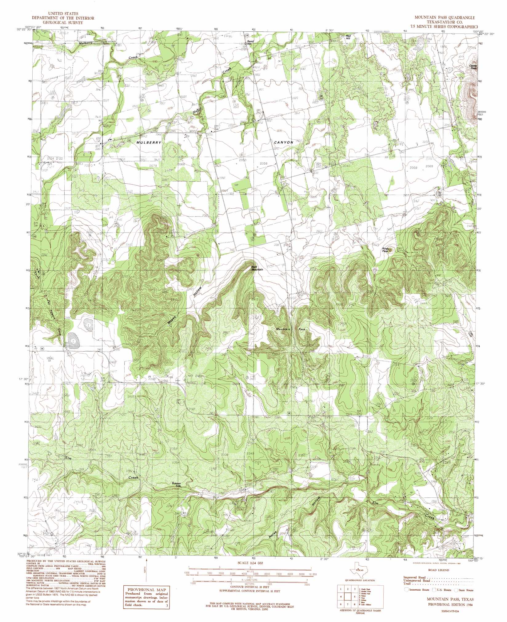
USGS Topo Quad 32100c1 - 1:24,000 scale
| Topo Map Name: | Mountain Pass |
| USGS Topo Quad ID: | 32100c1 |
| Print Size: | ca. 21 1/4" wide x 27" high |
| Southeast Coordinates: | 32.25° N latitude / 100° W longitude |
| Map Center Coordinates: | 32.3125° N latitude / 100.0625° W longitude |
| U.S. State: | TX |
| Filename: | o32100c1.jpg |
| Download Map JPG Image: | Mountain Pass topo map 1:24,000 scale |
| Map Type: | Topographic |
| Topo Series: | 7.5´ |
| Map Scale: | 1:24,000 |
| Source of Map Images: | United States Geological Survey (USGS) |
| Alternate Map Versions: |
Mountain Pass TX 1984, updated 1984 Download PDF Buy paper map Mountain Pass TX 1984, updated 1992 Download PDF Buy paper map Mountain Pass TX 2010 Download PDF Buy paper map Mountain Pass TX 2012 Download PDF Buy paper map Mountain Pass TX 2016 Download PDF Buy paper map |
1:24,000 Topo Quads surrounding Mountain Pass
Eskota |
Raven Creek South |
Noodle |
Stith |
Hawley |
Lake Sweetwater |
Chalk Peak |
Merkel West |
Merkel East |
Abilene West |
Holder Creek |
Nolan |
Mountain Pass |
View |
Buffalo Gap |
Blackwell Ne |
Hylton |
Shep |
Lake Abilene |
Tuscola |
Blackwell |
Church Peak |
Wingate |
Bradshaw |
Bald Knob |
> Back to 32100a1 at 1:100,000 scale
> Back to 32100a1 at 1:250,000 scale
> Back to U.S. Topo Maps home
Mountain Pass topo map: Gazetteer
Mountain Pass: Dams
Billy Doan Dam elevation 627m 2057′Hugh Lilly Lake Dam elevation 593m 1945′
Mountain Pass: Falls
Butman Falls elevation 705m 2312′Mountain Pass: Gaps
Mountain Pass elevation 680m 2230′Mountain Pass: Reservoirs
Billy Doan Reservoir elevation 627m 2057′Hugh Lilly Lake elevation 593m 1945′
Mountain Pass: Streams
Weaver Springs Creek elevation 622m 2040′Mountain Pass: Summits
Bald Mountain elevation 757m 2483′Riney Peak elevation 704m 2309′
Mountain Pass: Valleys
Horse Hollow elevation 685m 2247′Mapers Hollow elevation 651m 2135′
Mulberry Canyon elevation 613m 2011′
Pat Powers Cove elevation 702m 2303′
Mountain Pass digital topo map on disk
Buy this Mountain Pass topo map showing relief, roads, GPS coordinates and other geographical features, as a high-resolution digital map file on DVD: