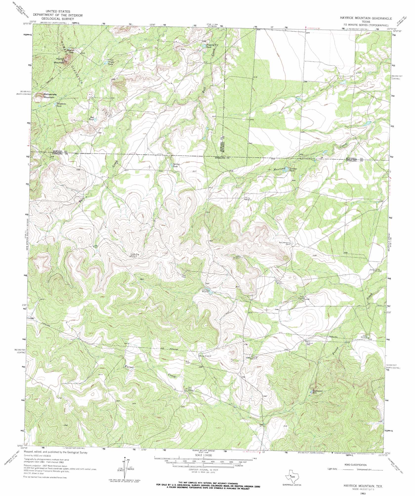
Hayrick Mountain Topo Map Texas
To zoom in, hover over the map of Hayrick Mountain
USGS Topo Quad 32101a2 - 1:24,000 scale
| Topo Map Name: | Hayrick Mountain |
| USGS Topo Quad ID: | 32101a2 |
| Print Size: | ca. 21 1/4" wide x 27" high |
| Southeast Coordinates: | 32° N latitude / 101.125° W longitude |
| Map Center Coordinates: | 32.0625° N latitude / 101.1875° W longitude |
| U.S. State: | TX |
| Filename: | o32101a2.jpg |
| Download Map JPG Image: | Hayrick Mountain topo map 1:24,000 scale |
| Map Type: | Topographic |
| Topo Series: | 7.5´ |
| Map Scale: | 1:24,000 |
| Source of Map Images: | United States Geological Survey (USGS) |
| Alternate Map Versions: |
Hayrick Mountain TX 1963, updated 1964 Download PDF Buy paper map Hayrick Mountain TX 2010 Download PDF Buy paper map Hayrick Mountain TX 2012 Download PDF Buy paper map Hayrick Mountain TX 2016 Download PDF Buy paper map |
1:24,000 Topo Quads surrounding Hayrick Mountain
Big Spring North |
Coahoma |
Iatan |
Westbrook |
Lake Colorado City |
Big Spring South |
Moss Creek Lake |
Hyman |
Hyman Ne |
Spade Ranch |
Lees |
Forsan |
Hayrick Mountain |
Buffalo Draw |
Mcwhorter Mountain |
Ballinger Ranch |
Garden City Ne |
Sand Bluff Draw |
Cumbie Draw Ne |
Sterling City Nw |
Garden City |
Currie Reservoir |
Glass Ranch |
Cumbie Draw |
Sterling City |
> Back to 32101a1 at 1:100,000 scale
> Back to 32100a1 at 1:250,000 scale
> Back to U.S. Topo Maps home
Hayrick Mountain topo map: Gazetteer
Hayrick Mountain: Lakes
Rockwater Hole elevation 748m 2454′Hayrick Mountain: Reservoirs
Dipping Vat Tank elevation 719m 2358′Hayrick Tank elevation 738m 2421′
Jackson Tank elevation 732m 2401′
Red Tank elevation 738m 2421′
Spring Tank elevation 752m 2467′
Telephone Tank elevation 738m 2421′
Triple Tank elevation 724m 2375′
Hayrick Mountain: Summits
Hayrick Mountain elevation 797m 2614′Rattlesnake Mountain elevation 769m 2522′
Hayrick Mountain digital topo map on disk
Buy this Hayrick Mountain topo map showing relief, roads, GPS coordinates and other geographical features, as a high-resolution digital map file on DVD: