Laguna Gatuna Nw Topo Map New Mexico
To zoom in, hover over the map of Laguna Gatuna Nw
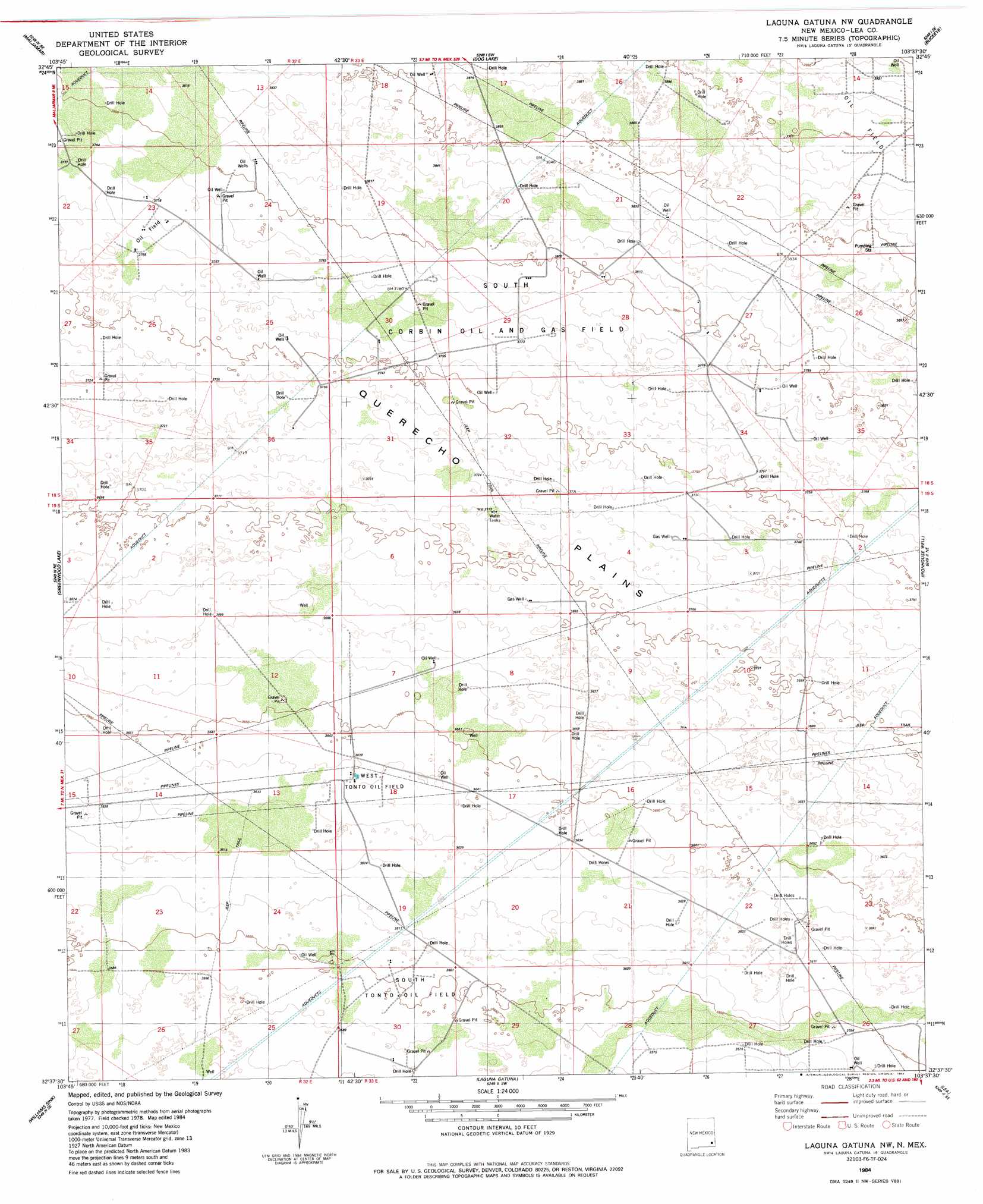
USGS Topo Quad 32103f6 - 1:24,000 scale
| Topo Map Name: | Laguna Gatuna Nw |
| USGS Topo Quad ID: | 32103f6 |
| Print Size: | ca. 21 1/4" wide x 27" high |
| Southeast Coordinates: | 32.625° N latitude / 103.625° W longitude |
| Map Center Coordinates: | 32.6875° N latitude / 103.6875° W longitude |
| U.S. State: | NM |
| Filename: | o32103f6.jpg |
| Download Map JPG Image: | Laguna Gatuna Nw topo map 1:24,000 scale |
| Map Type: | Topographic |
| Topo Series: | 7.5´ |
| Map Scale: | 1:24,000 |
| Source of Map Images: | United States Geological Survey (USGS) |
| Alternate Map Versions: |
Laguna Gatuna NW NM 1984, updated 1984 Download PDF Buy paper map Laguna Gatuna NW NM 2010 Download PDF Buy paper map Laguna Gatuna NW NM 2013 Download PDF Buy paper map Laguna Gatuna NW NM 2017 Download PDF Buy paper map |
1:24,000 Topo Quads surrounding Laguna Gatuna Nw
Henshaw Tank |
Maljamar Ne |
Buckeye Nw |
Buckeye Ne |
Lovington Nw |
Loco Hills |
Maljamar |
Dog Lake |
Buckeye |
Lovington Sw |
Hackberry Lake |
Greenwood Lake |
Laguna Gatuna Nw |
Ironhouse Well |
Ironhouse Draw |
Tower Hill North |
Williams Sink |
Laguna Gatuna |
Lea |
Monument Sw |
Tower Hill South |
Livingston Ridge |
The Divide |
Grama Ridge |
San Simon Ranch |
> Back to 32103e1 at 1:100,000 scale
> Back to 32102a1 at 1:250,000 scale
> Back to U.S. Topo Maps home
Laguna Gatuna Nw topo map: Gazetteer
Laguna Gatuna Nw: Areas
Querecho Plains elevation 1131m 3710′Laguna Gatuna Nw: Oilfields
Corbin Oil Field elevation 1190m 3904′South Corbin Oil and Gas Field elevation 1153m 3782′
South Tonto Oil Field elevation 1097m 3599′
Tonto Oil Field elevation 1108m 3635′
West Tonto Oil Field elevation 1110m 3641′
Laguna Gatuna Nw digital topo map on disk
Buy this Laguna Gatuna Nw topo map showing relief, roads, GPS coordinates and other geographical features, as a high-resolution digital map file on DVD: