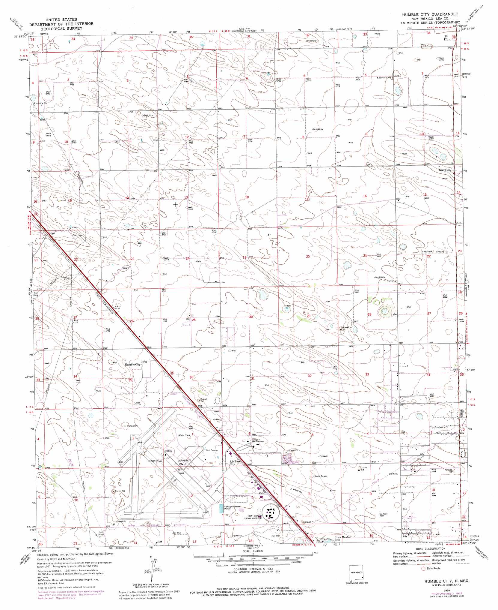
Humble City Topo Map New Mexico
To zoom in, hover over the map of Humble City
USGS Topo Quad 32103g2 - 1:24,000 scale
| Topo Map Name: | Humble City |
| USGS Topo Quad ID: | 32103g2 |
| Print Size: | ca. 21 1/4" wide x 27" high |
| Southeast Coordinates: | 32.75° N latitude / 103.125° W longitude |
| Map Center Coordinates: | 32.8125° N latitude / 103.1875° W longitude |
| U.S. State: | NM |
| Filename: | o32103g2.jpg |
| Download Map JPG Image: | Humble City topo map 1:24,000 scale |
| Map Type: | Topographic |
| Topo Series: | 7.5´ |
| Map Scale: | 1:24,000 |
| Source of Map Images: | United States Geological Survey (USGS) |
| Alternate Map Versions: |
Humble City NM 1969, updated 1971 Download PDF Buy paper map Humble City NM 1969, updated 1972 Download PDF Buy paper map Humble City NM 1969, updated 1980 Download PDF Buy paper map Humble City NM 1969, updated 1985 Download PDF Buy paper map Humble City NM 2010 Download PDF Buy paper map Humble City NM 2013 Download PDF Buy paper map Humble City NM 2017 Download PDF Buy paper map |
1:24,000 Topo Quads surrounding Humble City
Hillburn City Sw |
Hillburn City |
Prairieview |
Prairieview Se |
Ink Basin |
Lovington Nw |
Lovington |
Humble City Nw |
Humble City Ne |
Higginbotham |
Lovington Sw |
Lovington Se |
Humble City |
Humble City Se |
Denver City Sw |
Ironhouse Draw |
Monument North |
Hobbs West |
Hobbs East |
Paynes Corner Nw |
Monument Sw |
Monument South |
Hobbs Sw |
Hobbs Se |
Brinson Ranch |
> Back to 32103e1 at 1:100,000 scale
> Back to 32102a1 at 1:250,000 scale
> Back to U.S. Topo Maps home
Humble City topo map: Gazetteer
Humble City: Airports
Industrial Airpark elevation 1125m 3690′Humble City: Mines
Lea County Road Pit elevation 1120m 3674′Humble City: Parks
Harry McAdams State Park elevation 1125m 3690′Humble City: Populated Places
Air Base City elevation 1123m 3684′Humble City elevation 1131m 3710′
Knowles elevation 1131m 3710′
Humble City: Post Offices
Humble City Post Office (historical) elevation 1131m 3710′Knowles Post Office (historical) elevation 1131m 3710′
Humble City: Wells
10217 Water Well elevation 1133m 3717′10218 Water Well elevation 1142m 3746′
10219 Water Well elevation 1140m 3740′
10220 Water Well elevation 1134m 3720′
10221 Water Well elevation 1139m 3736′
10223 Water Well elevation 1136m 3727′
10226 Water Well elevation 1136m 3727′
10227 Water Well elevation 1136m 3727′
10228 Water Well elevation 1133m 3717′
10229 Water Well elevation 1140m 3740′
10230 Water Well elevation 1119m 3671′
10232 Water Well elevation 1116m 3661′
10233 Water Well elevation 1122m 3681′
10234 Water Well elevation 1127m 3697′
10235 Water Well elevation 1123m 3684′
10235 Water Well elevation 1129m 3704′
10236 Water Well elevation 1116m 3661′
10244 Water Well elevation 1114m 3654′
10245 Water Well elevation 1118m 3667′
Humble City digital topo map on disk
Buy this Humble City topo map showing relief, roads, GPS coordinates and other geographical features, as a high-resolution digital map file on DVD: