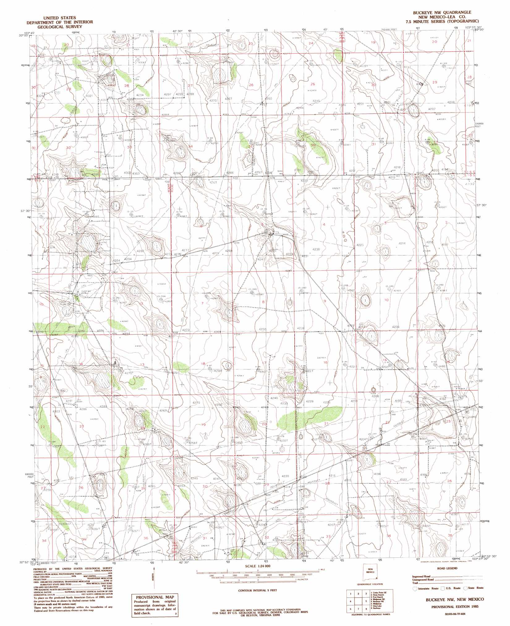
Buckeye Nw Topo Map New Mexico
To zoom in, hover over the map of Buckeye Nw
USGS Topo Quad 32103h6 - 1:24,000 scale
| Topo Map Name: | Buckeye Nw |
| USGS Topo Quad ID: | 32103h6 |
| Print Size: | ca. 21 1/4" wide x 27" high |
| Southeast Coordinates: | 32.875° N latitude / 103.625° W longitude |
| Map Center Coordinates: | 32.9375° N latitude / 103.6875° W longitude |
| U.S. State: | NM |
| Filename: | o32103h6.jpg |
| Download Map JPG Image: | Buckeye Nw topo map 1:24,000 scale |
| Map Type: | Topographic |
| Topo Series: | 7.5´ |
| Map Scale: | 1:24,000 |
| Source of Map Images: | United States Geological Survey (USGS) |
| Alternate Map Versions: |
Buckeye NW NM 1985, updated 1985 Download PDF Buy paper map Buckeye NW NM 2010 Download PDF Buy paper map Buckeye NW NM 2013 Download PDF Buy paper map Buckeye NW NM 2017 Download PDF Buy paper map |
1:24,000 Topo Quads surrounding Buckeye Nw
Vest Camp |
Caudill Ranch |
Cooper-Good Ranch |
Frier Ranch |
Alston Ranch |
Cedar Point |
Cedar Point Se |
Dean Ranch |
Fort Ranch |
Hillburn City Sw |
Henshaw Tank |
Maljamar Ne |
Buckeye Nw |
Buckeye Ne |
Lovington Nw |
Loco Hills |
Maljamar |
Dog Lake |
Buckeye |
Lovington Sw |
Hackberry Lake |
Greenwood Lake |
Laguna Gatuna Nw |
Ironhouse Well |
Ironhouse Draw |
> Back to 32103e1 at 1:100,000 scale
> Back to 32102a1 at 1:250,000 scale
> Back to U.S. Topo Maps home
Buckeye Nw topo map: Gazetteer
Buckeye Nw: Oilfields
East Anderson Oil Field elevation 1310m 4297′South Saunders Oil Field elevation 1285m 4215′
Buckeye Nw: Wells
11047 Water Well elevation 1303m 4274′11048 Water Well elevation 1310m 4297′
11049 Water Well elevation 1304m 4278′
11052 Water Well elevation 1307m 4288′
11053 Water Well elevation 1308m 4291′
11054 Water Well elevation 1305m 4281′
11055 Water Well elevation 1313m 4307′
11058 Water Well elevation 1298m 4258′
11059 Water Well elevation 1298m 4258′
11062 Water Well elevation 1304m 4278′
11064 Water Well elevation 1298m 4258′
11065 Water Well elevation 1281m 4202′
11066 Water Well elevation 1287m 4222′
11067 Water Well elevation 1298m 4258′
11068 Water Well elevation 1275m 4183′
11069 Water Well elevation 1279m 4196′
11072 Water Well elevation 1277m 4189′
11074 Water Well elevation 1284m 4212′
11075 Water Well elevation 1284m 4212′
11076 Water Well elevation 1282m 4206′
11078 Water Well elevation 1281m 4202′
11079 Water Well elevation 1272m 4173′
11430 Water Well elevation 1295m 4248′
11431 Water Well elevation 1294m 4245′
12374 Water Well elevation 1308m 4291′
12376 Water Well elevation 1308m 4291′
12377 Water Well elevation 1317m 4320′
12378 Water Well elevation 1303m 4274′
12379 Water Well elevation 1301m 4268′
12380 Water Well elevation 1298m 4258′
12394 Water Well elevation 1283m 4209′
12661 Water Well elevation 1307m 4288′
12662 Water Well elevation 1281m 4202′
12663 Water Well elevation 1292m 4238′
12753 Water Well elevation 1318m 4324′
12754 Water Well elevation 1299m 4261′
12762 Water Well elevation 1311m 4301′
12763 Water Well elevation 1301m 4268′
12765 Water Well elevation 1287m 4222′
12768 Water Well elevation 1280m 4199′
13213 Water Well elevation 1307m 4288′
13308 Water Well elevation 1291m 4235′
13316 Water Well elevation 1320m 4330′
13317 Water Well elevation 1319m 4327′
13318 Water Well elevation 1320m 4330′
13320 Water Well elevation 1287m 4222′
13321 Water Well elevation 1310m 4297′
13326 Water Well elevation 1283m 4209′
Buckeye Nw digital topo map on disk
Buy this Buckeye Nw topo map showing relief, roads, GPS coordinates and other geographical features, as a high-resolution digital map file on DVD: