Queen Topo Map New Mexico
To zoom in, hover over the map of Queen
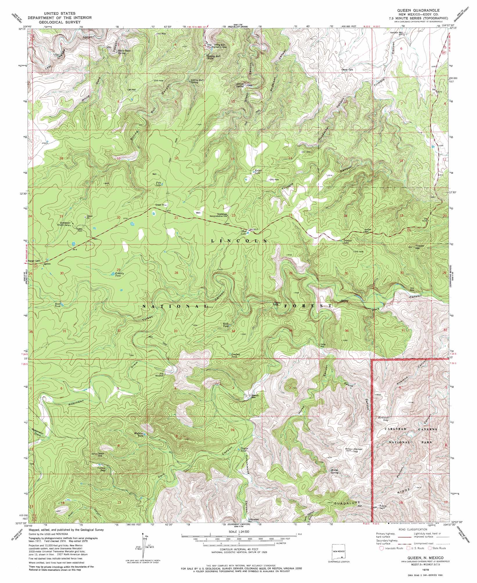
USGS Topo Quad 32104b6 - 1:24,000 scale
| Topo Map Name: | Queen |
| USGS Topo Quad ID: | 32104b6 |
| Print Size: | ca. 21 1/4" wide x 27" high |
| Southeast Coordinates: | 32.125° N latitude / 104.625° W longitude |
| Map Center Coordinates: | 32.1875° N latitude / 104.6875° W longitude |
| U.S. State: | NM |
| Filename: | o32104b6.jpg |
| Download Map JPG Image: | Queen topo map 1:24,000 scale |
| Map Type: | Topographic |
| Topo Series: | 7.5´ |
| Map Scale: | 1:24,000 |
| Source of Map Images: | United States Geological Survey (USGS) |
| Alternate Map Versions: |
Queen NM 1979, updated 1979 Download PDF Buy paper map Queen NM 1979, updated 1979 Download PDF Buy paper map Queen NM 2001, updated 2003 Download PDF Buy paper map Queen NM 2011 Download PDF Buy paper map Queen NM 2013 Download PDF Buy paper map Queen NM 2017 Download PDF Buy paper map |
| FStopo: | US Forest Service topo Queen is available: Download FStopo PDF Download FStopo TIF |
1:24,000 Topo Quads surrounding Queen
Packsaddle Canyon |
Texas Hill |
Cawley Draw |
Martha Creek |
Azotea Peak |
Algerita Canyon |
Ares Peak |
Red Bluff Draw |
Bandanna Point |
Carnero Peak |
La Paloma Canyon |
Pickett Hill |
Queen |
Serpentine Bends |
Carlsbad Caverns |
Panther Canyon |
El Paso Gap |
Gunsight Canyon |
Grapevine Draw |
Rattlesnake Spring |
P X Flat |
Guadalupe Peak |
Independence Spring |
South Rector Canyon |
Alligator Draw |
> Back to 32104a1 at 1:100,000 scale
> Back to 32104a1 at 1:250,000 scale
> Back to U.S. Topo Maps home
Queen topo map: Gazetteer
Queen: Areas
Sitting Bull Recreation Area elevation 1427m 4681′Queen: Falls
Sitting Bull Falls elevation 1437m 4714′Queen: Lakes
Juniper Lake elevation 1678m 5505′Kellar Lake elevation 1681m 5515′
Pats Lake elevation 1739m 5705′
Red Lake elevation 1713m 5620′
Queen: Parks
Sitting Bull Falls Point of Interest elevation 1445m 4740′Queen: Populated Places
Queen elevation 1781m 5843′Queen: Post Offices
Queen Post Office (historical) elevation 1781m 5843′Queen: Reservoirs
Cottonwood Storage Tank elevation 1759m 5770′Cowboy Tank elevation 1704m 5590′
Kite Windmill Storage Tank elevation 1718m 5636′
Priestly Tank elevation 1734m 5688′
Reed Tank elevation 1742m 5715′
Rock Tank elevation 1638m 5374′
Taylor Tank elevation 1694m 5557′
Watkins Tank elevation 1777m 5830′
Queen: Springs
Carson Seep elevation 1839m 6033′Gilson Spring elevation 1497m 4911′
Horse Spring elevation 1758m 5767′
Kirkland Seep elevation 1850m 6069′
Sitting Bull Spring elevation 1554m 5098′
White Oaks Spring elevation 1551m 5088′
Queen: Summits
Dinner Hill elevation 1952m 6404′Thayer Hill elevation 1687m 5534′
The Pinnacle elevation 1668m 5472′
Queen: Valleys
Cottonwood Canyon elevation 1686m 5531′Horse Canyon elevation 1590m 5216′
Huapache Canyon elevation 1353m 4438′
Kirkland Canyon elevation 1512m 4960′
Payne Canyon elevation 1605m 5265′
Robinson Draw elevation 1671m 5482′
Turkey Canyon elevation 1557m 5108′
Queen: Wells
Bearup Well elevation 1636m 5367′Cottonwood Well elevation 1759m 5770′
East Well elevation 1704m 5590′
Hamilton Well elevation 1331m 4366′
Horse Well elevation 1593m 5226′
Juniper Well elevation 1651m 5416′
Turkey Well elevation 1594m 5229′
Queen digital topo map on disk
Buy this Queen topo map showing relief, roads, GPS coordinates and other geographical features, as a high-resolution digital map file on DVD: